
| |||||
|
| Rwy | Rwy | |||||||
| 8000x200 | 8000' | 8000x200 | 8000' | |||||
| Runway ID | Single Wheel | Double Wheel | Double Tandem Wheel | Dual Double Wheel |
| 13/31 | N/A | N/A | N/A | N/A |
| These numbers are Advisory and are not limits. The Airport Manager should have more accurate Weight Limits | ||||
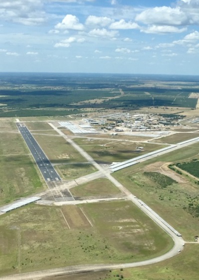
| Facility Name: | CHASE FLD INDUSTRIAL |
| City Name: | BEEVILLE |
| County: | BEE |
| State abbrev: | TX |
| State Name: | TEXAS |
| Ownership: | PUBLICLY OWNED |
| Use: | OPEN TO THE PUBLIC |
| Owner's Name: | BEEVILLE DEVELOPMENT AUTHORITY |
| Address: | 2745 PRIVATE BYRD ST |
| BEEVILLE, TX 78102 | |
| Owner's Phone: | 361-358-2023 |
| Manager's Name: | FRANK DOMINGUEZ |
| Address: | PO BOX 1448 |
| BEEVILLE, TX 78104 | |
| Phone: | 361-358-2023; 361-239-8899 MGR CELL. |
| FAA Region: | SOUTHWEST |
| FAA Field Office: | TEX |
| Date | Sunrise | Sunset |
|---|---|---|
| 04/24/24 Wednesday | 6:56 | 20:02 |
| 04/25/24 Thursday | 6:55 | 20:03 |
| 04/26/24 Friday | 6:54 | 20:03 |
| 04/27/24 Saturday | 6:53 | 20:04 |
| 04/28/24 Sunday | 6:52 | 20:04 |
| 04/29/24 Monday | 6:51 | 20:05 |
| 04/30/24 Tuesday | 6:50 | 20:06 |
| 05/01/24 Wednesday | 6:50 | 20:06 |
| 05/02/24 Thursday | 6:49 | 20:07 |
| 05/03/24 Friday | 6:48 | 20:07 |
| 05/04/24 Saturday | 6:47 | 20:08 |
| 05/05/24 Sunday | 6:46 | 20:08 |
| 05/06/24 Monday | 6:46 | 20:09 |
| 05/07/24 Tuesday | 6:45 | 20:10 |
| Airport Attendance Schedule | UNATTENDED |
| Airport Status | OPERATIONAL (This Status can change at any time - please check NOTAMS) |
| Airport Lighting Schedule | MIRL RWY 13/31 PRESET TO LOW INTST SS-SR; TO INCR INTST AND ACTVT - 122.8. |
| Airport Storage Available | NONE |
| Extra Services Available | NONE |
| Wind Indicator | YES - (unlit) |
| Control Tower | NO |
| CTAF Frequency | 122.800 |
| Unicom Frequency | 122.800 |
| Rotating Beacon Color | WG |
| Segmented Circle | NO |
| Landing Fee |
| Airport Inspected | 5010-1 PUBLIC USE MAILOUT PROGRAM - performed by PRIVATE CONTRACT PERSONNEL |
| Inspection Date | 05/25/2023 |
| Type of Fuel Available | JET A (freeze point -40C) |
| Airframe Repair Service | None |
| Power Plant Repair Service | None |
| Latitude | N2821.7 |
| Longitude | W09739.7 (ESTIMATED) |
| Arpt Elevation | 184ft (SURVEYED) |
| Magnetic Variation | 04E |
| 5 miles SE | of BEEVILLE |
| Traffic Pattern Altitude | |
| Sectional Chart | SAN ANTONIO |
| Operations (Reported) | Yearly | Avg. Daily |
|---|---|---|
| General Aviation Transient | 200 | 1 |
| General Aviation Local | 100 | 0 |
| Air Taxi | 0 | 0 |
| Commerical | 0 | 0 |
| Commuter | 0 | 0 |
| Military | 0 | 0 |
| Aircraft based on Field | |
|---|---|
| General Aviation Singles | 0 |
| General Aviation Multi | 1 |
| Jet Aircraft | 0 |
| General Aviation Helicopters | 0 |
| Military Aircraft | 0 |
| Gliders | 0 |
| Ultralights | 0 |
| FSS on field | NO |
| FSS tie-in | SAN ANGELO |
| FSS Phone | 1-800-WX-BRIEF |
| Who issues Notams | SJT |
| Notam D service at airport | YES |
| ARTCC Name | HOUSTON |
| Airport Certification | |
| Aircraft Rescue & Firefighting Index | None |
| Airport of Entry | No |
| Custom Landing Rights | No |
| Joint Civil/Military | No |
| Military Landing rights | No |
| FOR CD CTC HOUSTON ARTCC AT 281-230-5622. |
| RWY 13/31 CLSD TO TGLS. |
| ARPT FENCED, GATES LOCKED. FOR ACES CALL AMGR. |
| THE PREV PARL RWY 13R/31L CLSD. |
| RWY 13/3 1 RWY SFC ROUGH & UNEVEN, SPCLY BTN TXYS C2 & C5. LOOSE STONES THRUT. |
Airport Communications & Frequencies:
| |||||||||
| Runway: 13 | Runway: 31 | ||
| Mag heading: | 131° | Mag heading: | 311° |
| Rwy Slope: | -.11% Down | Rwy Slope: | .11% Up |
| Approach: | Approach: | ||
| Pattern: | Left Traffic | Pattern: | Left Traffic |
| Markings: | PRECISION INSTRUMENT | Markings: | PRECISION INSTRUMENT |
| Marking Condition: | FAIR | Marking Condition: | FAIR |
| Arresting Dev: | Arresting Dev: | ||
| Lat & Long: | N2822.2 W09740.2 | Lat. & Long.: | N2821.3 W09739.2 |
| Elev: | 181.7 ft. MSL | Elev: | 172.8 ft. MSL |
| TCH: | TCH: | ||
| Visual Glide Path: | Visual Glide Path: | ||
| Displaced Threshold: | No | Displaced Threshold: | No |
| Touchdown Zone: | YES | Touchdown Zone: | YES |
| Touchdown Elev.: | 184.2 feet | Touchdown Elev.: | 182.2 feet |
| Visual Glide Slope: | Visual Glide Slope: | ||
| RVR Equipment: | RVR Equipment: | ||
| RVV Equipment: | NO | RVV Equipment: | NO |
| Approach Lights: | Approach Lights: | ||
| REIL: | NO | REIL: | NO |
| Centerline Lights: | NO | Centerline Lights: | NO |
| Touchdown lights: | NO | Touchdown lights: | NO |
| Runway Category: | Runway with a Visual Approach | Runway Category: | Runway with a Visual Approach |
| Declared Distances: | Declared Distances: |