Current Weather/Notams (Metars, TAFs, Notams, NWS Forecast, PIREPS, and nearby weather)
Customs Information Send updates to Support@FltPlan.com
Customs Not Available
Database effective 05/16/2024
Airport Diagram might not be current.
|
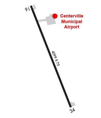
| Facility Name: | CENTERVILLE MUNI |
| City Name: | CENTERVILLE |
| County: | APPANOOSE |
| State abbrev: | IA |
| State Name: | IOWA |
| | |
| Ownership: | PUBLICLY OWNED |
| Use: | OPEN TO THE PUBLIC |
| Owner's Name: | CITY OF CENTERVILLE; CHMN ARPT COMM, DANNY GLENN |
| Address: | PO BOX 578 312 EAST MAPLE |
| | CENTERVILLE, IA 52544 |
| Owner's Phone: | 641-895-6844 |
| | |
| Manager's Name: | KEN MERCER; OR TONY KURY |
| Address: | 20320 545TH STREET |
| | CENTERVILLE, IA 52544 |
| Phone: | 641-437-4580 |
| | |
| FAA Region: | CENTRAL |
| FAA Field Office: | NONE |
Runway Identifications
Runway Identification: 16/34Length: 4099 ft
Width: 75 ft
Surface: CONCRETE-FAIR CONDITION
Edge lights: Medium IntensityTreatment: NONE
Weight: PCN 6 /R/C/W/U
| | Runway: 16 | | Runway: 34 |
| Mag heading: | 158° | Mag heading: | 338° |
| Rwy Slope: | -.01% Down | Rwy Slope: | .01% Up |
| Approach: | | Approach: | |
| Pattern: | Left Traffic | Pattern: | Left Traffic |
| Markings: | NONPRECISION INSTRUMENT | Markings: | NONPRECISION INSTRUMENT |
| Marking Condition: | FAIR | Marking Condition: | FAIR |
| Arresting Dev: | | Arresting Dev: | |
| Lat & Long: | N4041.4 W09254.2 | Lat. & Long.: | N4040.8 W09253.9 |
| Elev: | 1020.5 ft. MSL | Elev: | 1020.1 ft. MSL |
| TCH: | 43 ft. AGL | TCH: | 43 ft. AGL |
| Visual Glide Path: | 3.00 degrees | Visual Glide Path: | 3.00 degrees |
| Displaced Threshold: | No | Displaced Threshold: | No |
| Touchdown Zone: | YES | Touchdown Zone: | YES |
| Touchdown Elev.: | 1023.0 feet | Touchdown Elev.: | 1023.0 feet |
| Visual Glide Slope: | 4-Light PAPI on LEFT side of Runway | Visual Glide Slope: | 4-Light PAPI on LEFT side of Runway |
| RVR Equipment: | | RVR Equipment: | |
| RVV Equipment: | NO | RVV Equipment: | NO |
| Approach Lights: | | Approach Lights: | |
| REIL: | YES | REIL: | YES |
| Centerline Lights: | NO | Centerline Lights: | NO |
| Touchdown lights: | NO | Touchdown lights: | NO |
| Runway Category: | Runway with a Non-precision Approach having visibility minimums greater than 3/4 mile | Runway Category: | Runway with a Non-precision Approach having visibility minimums greater than 3/4 mile |
| Declared Distances: | | Declared Distances: | |
| Obstructions: | TREES | Obstructions: | |
| Marked: | NOT Marked/Lighted | Marked: | |
| Clearance slope: | 27:1 | Clearance slope: | 50:1 |
| Obstruction height: | 20 feet AGL | Obstruction height: | |
| Dist. from runway: | 744 feet | Dist. from runway: | |
| Centerline offset: | 131 right of centerline | Centerline offset: | |
| Comments: | | Comments: | |