Current Weather/Notams (Metars, TAFs, Notams, NWS Forecast, PIREPS, and nearby weather)
Customs Information Send updates to Support@FltPlan.com
Customs Not Available
Database effective 04/18/2024
Airport Diagram might not be current.
|
| Facility Name: | THOMASVILLE RGNL |
| City Name: | THOMASVILLE |
| County: | THOMAS |
| State abbrev: | GA |
| State Name: | GEORGIA |
| | |
| Ownership: | PUBLICLY OWNED |
| Use: | OPEN TO THE PUBLIC |
| Owner's Name: | CITY OF THOMASVILLE |
| Address: | PO BOX 1540 |
| | THOMASVILLE, GA 31799 |
| Owner's Phone: | 229-227-3262 |
| | |
| Manager's Name: | ROBERT PETTY |
| Address: | 882 AIRPORT RD |
| | THOMASVILLE, GA 31757 |
| Phone: | 229-225-4313 |
| | |
| FAA Region: | SOUTHERN |
| FAA Field Office: | ATL |
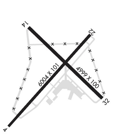
Runway Identifications
Runway Identification: 04/22Length: 6004 ft
Width: 101 ft
Surface: ASPHALT-GOOD CONDITION
Edge lights: High IntensityTreatment: NONE
| | Runway: 04 | | Runway: 22 |
| Mag heading: | 45° | Mag heading: | 225° |
| Rwy Slope: | -.14% Down | Rwy Slope: | .14% Up |
| Approach: | | Approach: | ILS/DME |
| Pattern: | Left Traffic | Pattern: | Left Traffic |
| Markings: | NONPRECISION INSTRUMENT | Markings: | PRECISION INSTRUMENT |
| Marking Condition: | GOOD | Marking Condition: | GOOD |
| Arresting Dev: | | Arresting Dev: | |
| Lat & Long: | N3053.6 W08353.3 | Lat. & Long.: | N3054.4 W08352.6 |
| Elev: | 238.2 ft. MSL | Elev: | 230.0 ft. MSL |
| TCH: | 54 ft. AGL | TCH: | 61 ft. AGL |
| Visual Glide Path: | 3.00 degrees | Visual Glide Path: | 3.00 degrees |
| Displaced Threshold: | 506 feet | Displaced Threshold: | No |
| Touchdown Zone: | YES | Touchdown Zone: | YES |
| Touchdown Elev.: | 241.7 feet | Touchdown Elev.: | 241.6 feet |
| Visual Glide Slope: | 2-Light PAPI on LEFT side of Runway | Visual Glide Slope: | 2-Light PAPI on LEFT side of Runway |
| RVR Equipment: | | RVR Equipment: | |
| RVV Equipment: | NO | RVV Equipment: | NO |
| Approach Lights: | | Approach Lights: | MALSF - 1,400 foot medium intensity approach lighting system with sequenced flashers |
| REIL: | NO | REIL: | NO |
| Centerline Lights: | NO | Centerline Lights: | NO |
| Touchdown lights: | NO | Touchdown lights: | NO |
| Runway Category: | Runway with a Non-precision Approach having visibility minimums greater than 3/4 mile | Runway Category: | Precision Instrument Runway |
| Declared Distances: | TORA:6004' TODA:6004' ASDA:6004' LDA:5498' | Declared Distances: | TORA:6004' TODA:6004' ASDA:5504' LDA:5504' |
| Obstructions: | | Obstructions: | TREES |
| Marked: | | Marked: | NOT Marked/Lighted |
| Clearance slope: | 34:1; OBST CLNC SLOPE 20:1 TO DTHR. | Clearance slope: | 19:1 |
| Obstruction height: | | Obstruction height: | 114 feet AGL |
| Dist. from runway: | | Dist. from runway: | 2366 feet |
| Centerline offset: | | Centerline offset: | 778 feet left of centerline |
| Comments: | | Comments: | |
Runway Identification: 14/32Length: 4999 ft
Width: 100 ft
Surface: ASPHALT-GOOD CONDITION
Edge lights: Low IntensityTreatment: NONE
| | Runway: 14 | | Runway: 32 |
| Mag heading: | 138° | Mag heading: | 318° |
| Rwy Slope: | -.28% Down | Rwy Slope: | .28% Up |
| Approach: | | Approach: | |
| Pattern: | Left Traffic | Pattern: | Left Traffic |
| Markings: | NONPRECISION INSTRUMENT | Markings: | NONPRECISION INSTRUMENT |
| Marking Condition: | GOOD | Marking Condition: | GOOD |
| Arresting Dev: | | Arresting Dev: | |
| Lat & Long: | N3054.4 W08353.2 | Lat. & Long.: | N3053.9 W08352.5 |
| Elev: | 263.6 ft. MSL | Elev: | 249.6 ft. MSL |
| TCH: | | TCH: | |
| Visual Glide Path: | | Visual Glide Path: | |
| Displaced Threshold: | No | Displaced Threshold: | No |
| Touchdown Zone: | YES | Touchdown Zone: | YES |
| Touchdown Elev.: | 263.6 feet | Touchdown Elev.: | 249.6 feet |
| Visual Glide Slope: | | Visual Glide Slope: | |
| RVR Equipment: | | RVR Equipment: | |
| RVV Equipment: | NO | RVV Equipment: | NO |
| Approach Lights: | | Approach Lights: | |
| REIL: | NO | REIL: | NO |
| Centerline Lights: | NO | Centerline Lights: | NO |
| Touchdown lights: | NO | Touchdown lights: | NO |
| Runway Category: | Runway with a Visual Approach | Runway Category: | Runway with a Visual Approach |
| Declared Distances: | | Declared Distances: | |
| Obstructions: | TREES | Obstructions: | |
| Marked: | NOT Marked/Lighted | Marked: | |
| Clearance slope: | 15:1 | Clearance slope: | 20:1 |
| Obstruction height: | 72 feet AGL | Obstruction height: | |
| Dist. from runway: | 1280 feet | Dist. from runway: | |
| Centerline offset: | 253 right of centerline | Centerline offset: | |
| Comments: | | Comments: | |