Current Weather/Notams (Metars, TAFs, Notams, NWS Forecast, PIREPS, and nearby weather)
Customs Information Send updates to Support@FltPlan.com
Customs Not Available
Database effective 04/18/2024
Airport Diagram might not be current.
|
| Facility Name: | CABOOL MEML |
| City Name: | CABOOL |
| County: | TEXAS |
| State abbrev: | MO |
| State Name: | MISSOURI |
| | |
| Ownership: | PUBLICLY OWNED |
| Use: | OPEN TO THE PUBLIC |
| Owner's Name: | CITY OF CABOOL |
| Address: | BOX 710, 618 MAIN ST. |
| | CABOOL, MO 65689 |
| Owner's Phone: | 417-962-3136 |
| | |
| Manager's Name: | RON SCHEETS |
| Address: | BOX 710, 618 MAIN ST |
| | CABOOL, MO 65689 |
| Phone: | 417-962-3136 |
| | |
| FAA Region: | CENTRAL |
| FAA Field Office: | NONE |
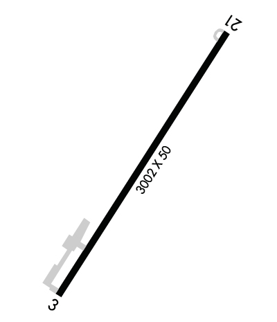
Runway Identifications
Runway Identification: 03/21Length: 3002 ft
Width: 60 ft
Surface: ASPHALT-GOOD CONDITION
Edge lights: Medium IntensityTreatment: AGGREGATE FRICTION SEAL COAT
| | Runway: 03 | | Runway: 21 |
| Mag heading: | 30° | Mag heading: | 210° |
| Rwy Slope: | -.37% Down | Rwy Slope: | .37% Up |
| Approach: | | Approach: | |
| Pattern: | Right Traffic | Pattern: | Left Traffic |
| Markings: | NONPRECISION INSTRUMENT | Markings: | NONPRECISION INSTRUMENT |
| Marking Condition: | GOOD | Marking Condition: | GOOD |
| Arresting Dev: | | Arresting Dev: | |
| Lat & Long: | N3707.7 W09205.2 | Lat. & Long.: | N3708.2 W09204.9 |
| Elev: | 1219.9 ft. MSL | Elev: | 1208.8 ft. MSL |
| TCH: | | TCH: | |
| Visual Glide Path: | | Visual Glide Path: | |
| Displaced Threshold: | 190 feet | Displaced Threshold: | No |
| Touchdown Zone: | YES | Touchdown Zone: | YES |
| Touchdown Elev.: | 1219.7 feet | Touchdown Elev.: | 1220.1 feet |
| Visual Glide Slope: | | Visual Glide Slope: | |
| RVR Equipment: | | RVR Equipment: | |
| RVV Equipment: | NO | RVV Equipment: | NO |
| Approach Lights: | | Approach Lights: | |
| REIL: | NO | REIL: | NO |
| Centerline Lights: | NO | Centerline Lights: | NO |
| Touchdown lights: | NO | Touchdown lights: | NO |
| Runway Category: | Runway with a Visual Approach | Runway Category: | Runway with a Non-precision Approach |
| Declared Distances: | | Declared Distances: | |
| Obstructions: | ROAD | Obstructions: | TREES |
| Marked: | NOT Marked/Lighted | Marked: | NOT Marked/Lighted |
| Clearance slope: | 6:1 | Clearance slope: | |
| Obstruction height: | 15 feet AGL | Obstruction height: | 30 feet AGL |
| Dist. from runway: | 300 feet | Dist. from runway: | 215 feet |
| Centerline offset: | 250 right of centerline | Centerline offset: | 210 feet left of centerline |
| Comments: | RY 03 +1-27 FT BRUSH & TREES, 120-200 FT FM RY END, 115-150 FT R; +35 FT TREES, 180-200 FT FM RY END 150-250 FT R. | Comments: | RWY 21 +28 FT TREES 120 FT FM RY END 200-250 FT L; +1-32 FT BRUSH & RR 0-200 FT FM RY END 200-250 FT R. |

