
| ||||||||||||||||||||||||||||||||||||||||||||
| ||||||||||||||||||||||||||||||||||||||||||||
| ||||||||||||||||||||||||||||||||||||||||||||
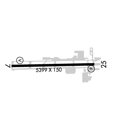
| Rwy | Rwy | |||||||
| 5399x150 | 5399' | 5399x150 | 5046' | |||||
| Runway ID | Single Wheel | Double Wheel | Double Tandem Wheel | Dual Double Wheel |
| 07/25 | 19,000 | 25,000 | N/A | N/A |
| These numbers are Advisory and are not limits. The Airport Manager should have more accurate Weight Limits | ||||
 Airport Diagram might not be current. | |
| Facility Name: | PORTLAND-TROUTDALE |
| City Name: | PORTLAND |
| County: | MULTNOMAH |
| State abbrev: | OR |
| State Name: | OREGON |
| Ownership: | PUBLICLY OWNED |
| Use: | OPEN TO THE PUBLIC |
| Owner's Name: | THE PORT OF PORTLAND |
| Address: | BOX 3529 |
| PORTLAND, OR 97208 | |
| Owner's Phone: | 503-944-7000 |
| Manager's Name: | KAMA SIMONDS |
| Address: | PORT OF PORTLAND BOX 3529 |
| PORTLAND, OR 97208 | |
| Phone: | 503-415-6119 |
| FAA Region: | NORTHWEST MOUNTAIN |
| FAA Field Office: | SEA |
| Date | Sunrise | Sunset |
|---|---|---|
| 04/23/24 Tuesday | 6:09 | 20:07 |
| 04/24/24 Wednesday | 6:07 | 20:09 |
| 04/25/24 Thursday | 6:06 | 20:10 |
| 04/26/24 Friday | 6:04 | 20:11 |
| 04/27/24 Saturday | 6:02 | 20:13 |
| 04/28/24 Sunday | 6:01 | 20:14 |
| 04/29/24 Monday | 5:59 | 20:15 |
| 04/30/24 Tuesday | 5:58 | 20:16 |
| 05/01/24 Wednesday | 5:56 | 20:18 |
| 05/02/24 Thursday | 5:55 | 20:19 |
| 05/03/24 Friday | 5:53 | 20:20 |
| 05/04/24 Saturday | 5:52 | 20:21 |
| 05/05/24 Sunday | 5:50 | 20:23 |
| 05/06/24 Monday | 5:49 | 20:24 |
| Airport Attendance Schedule | 7 Days A Week 0700-2200 |
| Airport Status | OPERATIONAL (This Status can change at any time - please check NOTAMS) |
| Airport Lighting Schedule | ACTVT MIRL RY 07/25 - CTAF. RY 07 VASI & RY 25 PAPI OPER CONT. |
| Airport Storage Available | Tie Downs, Hanger |
| Extra Services Available | Avionics, Charter, Flight Instruction, Aircraft Rental, Aircraft Sales |
| Wind Indicator | YES - (lighted) |
| Control Tower | YES |
| CTAF Frequency | 120.900 |
| Unicom Frequency | 122.950 |
| Rotating Beacon Color | WG |
| Segmented Circle | YES |
| Landing Fee | YES; COMMERCIAL ACFT & OPERATORS OF ACFT WITH AN FAA CERTIFIED MAX GROSS LANDING WEIGHT THAT EXCEEDS 10000 LBS ARE REQUIRED TO PAY A LANDING FEE. |
| Airport Inspected | STATE - performed by STATE AERONAUTICAL PERSONNEL |
| Inspection Date | 09/28/2023 |
| Type of Fuel Available | Grade 100LL, JET A (freeze point -40C) |
| Airframe Repair Service | MAJOR |
| Power Plant Repair Service | MAJOR |
| Latitude | N4533.0 |
| Longitude | W12224.1 (ESTIMATED) |
| Arpt Elevation | 38ft (SURVEYED) |
| Magnetic Variation | 16E |
| 10 miles E | of PORTLAND |
| Traffic Pattern Altitude | |
| Sectional Chart | SEATTLE |
| Operations (Reported) | Yearly | Avg. Daily |
|---|---|---|
| General Aviation Transient | 29520 | 81 |
| General Aviation Local | 70000 | 192 |
| Air Taxi | 4000 | 11 |
| Commerical | 0 | 0 |
| Commuter | 0 | 0 |
| Military | 1500 | 4 |
| Aircraft based on Field | |
|---|---|
| General Aviation Singles | 60 |
| General Aviation Multi | 2 |
| Jet Aircraft | 0 |
| General Aviation Helicopters | 11 |
| Military Aircraft | 0 |
| Gliders | 0 |
| Ultralights | 0 |
| FSS on field | NO |
| FSS tie-in | MC MINNVILLE |
| FSS Phone | 1-800-WX-BRIEF |
| Who issues Notams | TTD |
| Notam D service at airport | YES |
| ARTCC Name | SEATTLE |
| Airport Certification | |
| Aircraft Rescue & Firefighting Index | None |
| Airport of Entry | No |
| Custom Landing Rights | No |
| Joint Civil/Military | No |
| Military Landing rights | YES |
| NATIONAL PLAN OF INTEGRATED AIRPORT SYSTEMS (NPIAS) |
| GRANT AGREEMENTS UNDER FAAP/ADAP/AIP |
| ASSURANCES PURSUANT TO TITLE VI, CIVIL RIGHTS ACT OF 1964 |
| AGREEMENT UNDER DLAND OR DCLA HAS EXPIRED. |
| MIGRATORY FLOCKSOF WATERFOWL ON & INVOF ARPT. |
| FOR CD CTC PORTLAND APCH AT 503-493-7545. |
| PORTLAND INTL ARPT RY 10L/28R EXTNDD CENTERLINE CROSSES ARPT, ATCT MAY ISSUE RESTRICCTIONS DUE TO PDX TFC. |
| NOISE ABATEMENT PROCEDURES IN EFFECT. CALL 503-460-4100 OR 800-938-6647. |
| NOISE SENSITIVE AREAS BORDER THE ARPT WEST AND SOUTH. |
| AVOID LOW-LEVEL OVERFLIGHTS OF RESIDENTIAL AREAS. |
| RECOMMEND BETWEEN SS AND SR, RY 7 LEFT TFC AND RY 25 RIGHT TFC DUE TO BLUFF 5000 FT SOUTH OF ARPT. |
| EXTENSIVE HELICOPTER OPS ON AND ADJACENT TO WEST ENDS OF THE PARALLEL TWYS, NO EARLY TURNOUTS. |
| MULTIPLE CONST CRANES 110 FT AGL OR BLO LOCATED 2700 FT SW OF RY 25 THLD. |
Airport Communications & Frequencies:
| ||||||||||||||||||||||||||
| Runway: 07 | Runway: 25 | ||
| Mag heading: | 73° | Mag heading: | 253° |
| Rwy Slope: | .21% Up | Rwy Slope: | -.21% Down |
| Approach: | Approach: | ||
| Pattern: | Left Traffic | Pattern: | Left Traffic |
| Markings: | NONPRECISION INSTRUMENT | Markings: | NONPRECISION INSTRUMENT |
| Marking Condition: | GOOD | Marking Condition: | GOOD |
| Arresting Dev: | Arresting Dev: | ||
| Lat & Long: | N4533.0 W12224.7 | Lat. & Long.: | N4533.0 W12223.4 |
| Elev: | 27.8 ft. MSL | Elev: | 38.9 ft. MSL |
| TCH: | 50 ft. AGL | TCH: | 31 ft. AGL |
| Visual Glide Path: | 3.00 degrees | Visual Glide Path: | 3.10 degrees |
| Displaced Threshold: | No | Displaced Threshold: | 353 feet |
| Touchdown Zone: | YES | Touchdown Zone: | YES |
| Touchdown Elev.: | 32.4 feet | Touchdown Elev.: | 38.9 feet |
| Visual Glide Slope: | 4-BOX VASI ON LEFT SIDE OF RUNWAY | Visual Glide Slope: | 4-Light PAPI on LEFT side of Runway; RY 25 PAPI IS BAFFLED 08 DEG L AND R OF CNTRLN. |
| RVR Equipment: | RVR Equipment: | ||
| RVV Equipment: | NO | RVV Equipment: | NO |
| Approach Lights: | Approach Lights: | ||
| REIL: | YES | REIL: | YES |
| Centerline Lights: | NO | Centerline Lights: | NO |
| Touchdown lights: | NO | Touchdown lights: | NO |
| Runway Category: | Runway with a Visual Approach | Runway Category: | Runway with a Visual Approach |
| Declared Distances: | Declared Distances: | TORA:5399' TODA:5399' ASDA:5399' LDA:5046' | |
| Obstructions: | TREES | Obstructions: | TREES; APCH RATIO 27:1; DIKE AT 588' LGTD. |
| Marked: | NOT Marked/Lighted | Marked: | NOT Marked/Lighted |
| Clearance slope: | 18:1; APCH CLNC SLOPE FROM DTHR IS 45:1 BASED ON 21' ROAD AT 817'. | Clearance slope: | 23:1 |
| Obstruction height: | 105 feet AGL | Obstruction height: | 63 feet AGL |
| Dist. from runway: | 2100 feet | Dist. from runway: | 1653 feet |
| Centerline offset: | Centerline offset: | ||
| Comments: | Comments: |
