| |||||||||||||||||||||||||||||||||||||||||||||||||||||||||||||||||||||
| |||||||||||||||||||||||||||||||||||||||||||||||||||||||||||||||||||||
| |||||||||||||||||||||||||||||||||||||||||||||||||||||||||||||||||||||
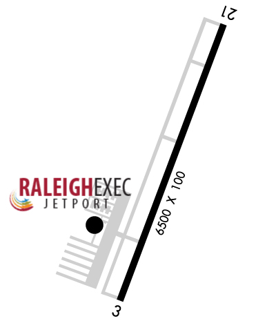
| Rwy | Rwy | |||||||
| 6501x100 | 6501' | 110.75 - 029° | 6501x100 | 6501' | ||||
| Runway ID | Single Wheel | Double Wheel | Double Tandem Wheel | Dual Double Wheel |
| 03/21 | 30,000 | 100,000 | N/A | N/A |
| These numbers are Advisory and are not limits. The Airport Manager should have more accurate Weight Limits | ||||
 Airport Diagram might not be current. | |
| Facility Name: | RALEIGH EXEC JETPORT AT SANFORD-LEE COUNTY |
| City Name: | SANFORD |
| County: | LEE |
| State abbrev: | NC |
| State Name: | NORTH CAROLINA |
| Ownership: | PUBLICLY OWNED |
| Use: | OPEN TO THE PUBLIC |
| Owner's Name: | SANFORD-LEE COUNTY RGNL ARPT AUTH |
| Address: | 700 ROD SULLIVAN RD |
| SANFORD, NC 27330 | |
| Owner's Phone: | 919-776-2939 |
| Manager's Name: | BOB HEUTS |
| Address: | 700 ROD SULLIVAN RD. |
| SANFORD, NC 27330 | |
| Phone: | 919-776-2939 |
| FAA Region: | SOUTHERN |
| FAA Field Office: | MEM |
| Date | Sunrise | Sunset |
|---|---|---|
| 04/24/24 Wednesday | 6:32 | 19:58 |
| 04/25/24 Thursday | 6:30 | 19:59 |
| 04/26/24 Friday | 6:29 | 19:59 |
| 04/27/24 Saturday | 6:28 | 20:00 |
| 04/28/24 Sunday | 6:27 | 20:01 |
| 04/29/24 Monday | 6:26 | 20:02 |
| 04/30/24 Tuesday | 6:25 | 20:03 |
| 05/01/24 Wednesday | 6:24 | 20:04 |
| 05/02/24 Thursday | 6:23 | 20:04 |
| 05/03/24 Friday | 6:22 | 20:05 |
| 05/04/24 Saturday | 6:21 | 20:06 |
| 05/05/24 Sunday | 6:20 | 20:07 |
| 05/06/24 Monday | 6:19 | 20:08 |
| 05/07/24 Tuesday | 6:18 | 20:09 |
| Airport Attendance Schedule | 7 Days A Week 0800-1800; FOR SVC AFTER HOURS CALL 919-708-3065. |
| Airport Status | OPERATIONAL (This Status can change at any time - please check NOTAMS) |
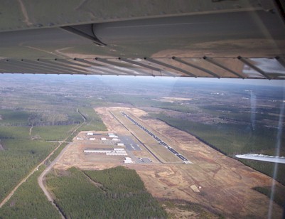
| Airport Lighting Schedule | DUSK-DAWN. ACTVT MALSR RWY 03; REIL RWY 21; HIRL RWY 03/21 - CTAF. PAPI RWYS 03 & 21 ON CONSLY. |
| Airport Storage Available | Tie Downs |
| Extra Services Available | Avionics, Cargo Handling, Charter, Flight Instruction, Aircraft Rental, Aircraft Sales |
| Wind Indicator | YES - (lighted) |
| Control Tower | NO |
| CTAF Frequency | 123.075 |
| Unicom Frequency | 123.075 |
| Rotating Beacon Color | WG |
| Segmented Circle | YES |
| Landing Fee |
| Airport Inspected | STATE - performed by STATE AERONAUTICAL PERSONNEL |
| Inspection Date | 08/17/2022 |
| Type of Fuel Available | Grade 100LL, JET A-1 (icing inhibitor, freeze point -50C); -10100LL 24 HR SELF-SERVICE WITH CREDIT CARD. |
| Airframe Repair Service | MAJOR |
| Power Plant Repair Service | MAJOR |
| Latitude | N3534.9 |
| Longitude | W07906.1 (ESTIMATED) |
| Arpt Elevation | 246ft (SURVEYED) |
| Magnetic Variation | 08W |
| 7 miles NE | of SANFORD |
| Traffic Pattern Altitude | |
| Sectional Chart | CHARLOTTE |
| Operations (Reported) | Yearly | Avg. Daily |
|---|---|---|
| General Aviation Transient | 12000 | 33 |
| General Aviation Local | 48000 | 132 |
| Air Taxi | 2000 | 5 |
| Commerical | 0 | 0 |
| Commuter | 0 | 0 |
| Military | 1000 | 3 |
| Aircraft based on Field | |
|---|---|
| General Aviation Singles | 186 |
| General Aviation Multi | 8 |
| Jet Aircraft | 11 |
| General Aviation Helicopters | 3 |
| Military Aircraft | 0 |
| Gliders | 1 |
| Ultralights | 0 |
| FSS on field | NO |
| FSS tie-in | RALEIGH |
| FSS Phone | 1-800-WX-BRIEF |
| Who issues Notams | TTA |
| Notam D service at airport | YES |
| ARTCC Name | WASHINGTON |
| Airport Certification | |
| Aircraft Rescue & Firefighting Index | None |
| Airport of Entry | No |
| Custom Landing Rights | No |
| Joint Civil/Military | No |
| Military Landing rights | No |
| NATIONAL PLAN OF INTEGRATED AIRPORT SYSTEMS (NPIAS) |
| GRANT AGREEMENTS UNDER FAAP/ADAP/AIP |
| COMPLIANCE WITH ACCESSIBILITY TO THE HANDICAPPED |
| ASSURANCES PURSUANT TO TITLE VI, CIVIL RIGHTS ACT OF 1964 |
| FOR CD CTC RALEIGH APCH AT 919-380-3144. |
| USE RWY 03 FOR CALM WIND RWY. |
| TWY A 15-30 FT DROP-OFF INVOF TWYS A3 AND A4. |
Airport Communications & Frequencies:
| ||||||||||||||
| Runway: 03 | Runway: 21 | ||
| Mag heading: | 29° | Mag heading: | 209° |
| Rwy Slope: | -.34% Down | Rwy Slope: | .34% Up |
| Approach: | ILS/DME | Approach: | |
| Pattern: | Left Traffic | Pattern: | Left Traffic |
| Markings: | PRECISION INSTRUMENT | Markings: | NONPRECISION INSTRUMENT |
| Marking Condition: | GOOD | Marking Condition: | GOOD |
| Arresting Dev: | Arresting Dev: | ||
| Lat & Long: | N3534.4 W07906.3 | Lat. & Long.: | N3535.4 W07905.8 |
| Elev: | 246.5 ft. MSL | Elev: | 224.2 ft. MSL |
| TCH: | 45 ft. AGL | TCH: | 40 ft. AGL |
| Visual Glide Path: | 3.00 degrees | Visual Glide Path: | 3.00 degrees |
| Displaced Threshold: | No | Displaced Threshold: | No |
| Touchdown Zone: | YES | Touchdown Zone: | YES |
| Touchdown Elev.: | 246.6 feet | Touchdown Elev.: | 229.8 feet |
| Visual Glide Slope: | 4-Light PAPI on LEFT side of Runway | Visual Glide Slope: | 4-Light PAPI on LEFT side of Runway |
| RVR Equipment: | RVR Equipment: | ||
| RVV Equipment: | NO | RVV Equipment: | NO |
| Approach Lights: | MALSR - 1,400 foot medium intensity approach lighting system with runway alignment indicator lights | Approach Lights: | |
| REIL: | NO | REIL: | YES |
| Centerline Lights: | NO | Centerline Lights: | NO |
| Touchdown lights: | NO | Touchdown lights: | NO |
| Runway Category: | Precision Instrument Runway | Runway Category: | Runway with a Non-precision Approach having visibility minimums greater than 3/4 mile |
| Declared Distances: | Declared Distances: | ||
| Obstructions: | TREES | Obstructions: | TREES |
| Marked: | NOT Marked/Lighted | Marked: | NOT Marked/Lighted |
| Clearance slope: | 39:1 | Clearance slope: | 28:1 |
| Obstruction height: | 58 feet AGL | Obstruction height: | 71 feet AGL |
| Dist. from runway: | 2493 feet | Dist. from runway: | 2194 feet |
| Centerline offset: | 174 right of centerline | Centerline offset: | 142 feet left of centerline |
| Comments: | Comments: |