Click here for more info on on SMS!

KTSP

TEHACHAPI MUNI
TEHACHAPI
CA
Time Zone: Pacific
Lat: N 3508.1
Long: W 11826.4
Elev: 4001
Var: -14
Longest Runway: 4040
AWOS: 120.02
CTAF: 123.0

FBO & Flight Services info for KTSP

FBOs: Update your Fuel Prices

TEHACHAPI MUNPh: 661-822-2220 Fax: 661-822-8559 Freq: 123.0
Service
Jet
100LL
SAF
MoGas
Fuel Avail: JETA INCLUDES PRIST. Visa, AmExpress, MasterCard, MULTI
Full        Last Update: 04/07/2024 08:50

Self4.315.41    
 Address: 115 SOUTH ROBINSON ST   TEHACHAPI, CA 93561-1722
AWOSPh: 661-823-0473
-
Freq: 120.02  
If you are an FBO, call 1-203-262-1700 to update your info or email: FltPlan.Advertising@garmin.com
Advertise your FBO on FltPlan.com

Runway & Approach Info for KTSP
Rwy
Length
Land Dist**
Approach*
  Rwy
Length
Land Dist**
Approach*
11
4040x75  3740'          
 
  
29
  4040x75  3673'          
 
 * only ILS, LOC, LDA, and SDF approaches to a specific runway are shown
** For any Declared Landing Distance Available, please see A/FD or Approach plates
Runway Weight Capability (lbs.) Help
Runway IDSingle WheelDouble WheelDouble Tandem WheelDual Double Wheel
11/29N/AN/AN/AN/A
These numbers are Advisory and are not limits.   The Airport Manager should have more accurate Weight Limits
Approach Charts
FltPlan does not have IFR approach charts available for KTSP.
Current Weather/Notams
Customs Information Send updates to Support@FltPlan.com
Customs Not Available
Database effective 05/16/2024
Airport Diagram of KTSP
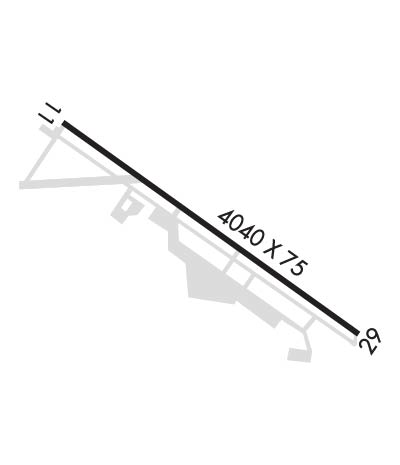
Airport Diagram might not be current.

Facility Name: TEHACHAPI MUNI
City Name: TEHACHAPI
County: KERN
State abbrev: CA
State Name: CALIFORNIA
   
Ownership: PUBLICLY OWNED
Use: OPEN TO THE PUBLIC
Owner's Name: CITY OF TEHACHAPI
Address: 115 SOUTH ROBINSON
 TEHACHAPI, CA 93581
Owner's Phone: 661-822-2200
  
Manager's Name: ASHLEY WHITMORE
Address: 115 SOUTH ROBINSON STREET
 TEHACHAPI, CA 93561
Phone: (661) 822-2200; OFFICE 661-822-2200 X133. MOBILE 661-619-1356.
   
FAA Region: WESTERN-PACIFIC
FAA Field Office: LAX


Sunrise / Sunset times for TEHACHAPI MUNI

DateSunriseSunset
04/24/24 Wednesday6:1019:34
04/25/24 Thursday6:0819:35
04/26/24 Friday6:0719:36
04/27/24 Saturday6:0619:37
04/28/24 Sunday6:0519:38
04/29/24 Monday6:0419:39
04/30/24 Tuesday6:0319:39
05/01/24 Wednesday6:0219:40
05/02/24 Thursday6:0119:41
05/03/24 Friday6:0019:42
05/04/24 Saturday5:5919:43
05/05/24 Sunday5:5819:43
05/06/24 Monday5:5719:44
05/07/24 Tuesday5:5619:45

Airport Facilities

Airport Attendance Schedule7 Days A Week 0700-1730; FOR AFTER HRS OR EMERG CALL 661-822-2222
Airport Status OPERATIONAL (This Status can change at any time - please check NOTAMS)
Airport Lighting ScheduleACTVT HIRL RY 11/29 - CTAF.
Airport Storage AvailableTie Downs
Extra Services AvailableFlight Instruction, Aircraft Rental
Wind IndicatorYES - (lighted)
Control TowerNO
CTAF Frequency123.000
Unicom Frequency123.000
Rotating Beacon ColorWG
Segmented CircleYES
Landing FeeNO

Airport Inspection Data

Airport InspectedSTATE - performed by STATE AERONAUTICAL PERSONNEL
Inspection Date05/24/2023

Airport Services

Type of Fuel AvailableGrade 100LL, JET A (freeze point -40C); -10FUEL 24 HRS CREDIT CARD.
Airframe Repair ServiceMAJOR
Power Plant Repair ServiceMAJOR

Geographic Data

LatitudeN3508.1
LongitudeW11826.4 (ESTIMATED)
Arpt Elevation4001ft (SURVEYED)
Magnetic Variation14E
0 miles NEof TEHACHAPI
Traffic Pattern Altitude
Sectional ChartLOS ANGELES

Aircraft Data

Operations (Reported)YearlyAvg. Daily
General Aviation Transient 650018
General Aviation Local 450012
Air Taxi 00
Commerical 00
Commuter 00
Military 00
Aircraft based on Field
General Aviation Singles 42
General Aviation Multi 2
Jet Aircraft 1
General Aviation Helicopters 2
Military Aircraft 0
Gliders 0
Ultralights 0

FAA Services

FSS on field NO
FSS tie-in RANCHO MURIETA
FSS Phone 1-800-WX-BRIEF
Who issues Notams RIU
Notam D service at airport YES
ARTCC Name LOS ANGELES

Federal Status

Airport Certification
Aircraft Rescue & Firefighting IndexNone
Airport of EntryNo
Custom Landing RightsNo
Joint Civil/MilitaryNo
Military Landing rightsYES

Federal Agreements

NATIONAL PLAN OF INTEGRATED AIRPORT SYSTEMS (NPIAS)
GRANT AGREEMENTS UNDER FAAP/ADAP/AIP
ASSURANCES PURSUANT TO TITLE VI, CIVIL RIGHTS ACT OF 1964

Remarks

LGTD OBSTN/MOUNTAIN/1 MI WEST OF ARPT (4279' MSL).
FOR CD CTC LOS ANGELES ARTCC AT 661-575-2079.
RWY 11/2 9 GWT PAVEMENT STRENGTH PRVDD BY ARPT MANAGER: 25000 LBS.
Runway Identifications
Runway Identification: 11/29
Length: 4040 ft
Width: 75 ft
Surface: ASPHALT-GOOD CONDITION
Edge lights: High Intensity

Treatment: NONE

 Runway: 11   Runway: 29
Mag heading: 110°Mag heading: 290°
Rwy Slope: 1.06% UpRwy Slope: -1.06% Down
Approach: Approach:
Pattern: Right TrafficPattern: Left Traffic
Markings: BASICMarkings: BASIC
Marking Condition: GOODMarking Condition: GOOD
Arresting Dev: Arresting Dev:
Lat & Long: N3508.3  W11826.7Lat. & Long.: N3507.9  W11826.0
Elev: 3958.1 ft. MSLElev: 4001.1 ft. MSL
TCH: 42 ft. AGLTCH: 15 ft. AGL
Visual Glide Path: 3.00 degreesVisual Glide Path: 3.50 degrees
Displaced Threshold: 300 feetDisplaced Threshold: 367 feet
Touchdown Zone: YESTouchdown Zone: YES
Touchdown Elev.: 3993.3 feetTouchdown Elev.: 3997.3 feet
Visual Glide Slope: 2-Light PAPI on LEFT side of RunwayVisual Glide Slope: 2-Light PAPI on LEFT side of Runway; UNUSBL BYD 4 NM DUE TO TRRN.
RVR Equipment: RVR Equipment:
RVV Equipment: NORVV Equipment: NO
Approach Lights: Approach Lights:
REIL: YESREIL: YES
Centerline Lights: NOCenterline Lights: NO
Touchdown lights: NOTouchdown lights: NO
Runway Category: Runway with a Visual ApproachRunway Category: Runway with a Visual Approach
Declared Distances: Declared Distances:
Obstructions: HILLObstructions: RR
Marked: NOT Marked/LightedMarked: NOT Marked/Lighted
Clearance slope: 16:1; APCH RATIO TO DSPLCD THR 18:1.Clearance slope: 13:1; APCH RATIO TO DSPLCD THR 31:1.
Obstruction height: 276 feet AGLObstruction height: 32 feet AGL
Dist. from runway: 4800 feetDist. from runway: 635 feet
Centerline offset: Centerline offset: 165 feet left of centerline
Comments: Comments:
C:1/P: