Current Weather/Notams (Metars, TAFs, Notams, NWS Forecast, PIREPS, and nearby weather)
Customs Information Send updates to Support@FltPlan.com
Customs Not Available
Database effective 05/16/2024
Airport Diagram might not be current.
|
| Facility Name: | CARROLL COUNTY-TOLSON |
| City Name: | CARROLLTON |
| County: | CARROLL |
| State abbrev: | OH |
| State Name: | OHIO |
| | |
| Ownership: | PUBLICLY OWNED |
| Use: | OPEN TO THE PUBLIC |
| Owner's Name: | CARROLL COUNTY ARPT AUTH |
| Address: | PO BOX 266 |
| | CARROLLTON, OH 44615-0266 |
| Owner's Phone: | 330-323-8626 |
| | |
| Manager's Name: | AL JESKE |
| Address: | 46 E MOHAWK DR |
| | MALVERN, OH 44644-9554 |
| Phone: | 330-323-8626; RESTAURANT/FUEL ASSISTANCE 330-627-5250; AFT HRS CTC NGT SHERIFF 330-627-2141. |
| | |
| FAA Region: | GREAT LAKES |
| FAA Field Office: | DET |
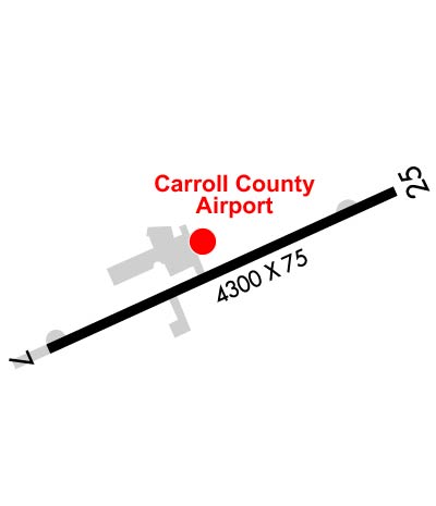
Runway Identifications
Runway Identification: 07/25Length: 4300 ft
Width: 75 ft
Surface: ASPHALT-FAIR CONDITION
Edge lights: Medium IntensityTreatment: NONE
| | Runway: 07 | | Runway: 25 |
| Mag heading: | 71° | Mag heading: | 251° |
| Rwy Slope: | .05% Up | Rwy Slope: | -.05% Down |
| Approach: | | Approach: | |
| Pattern: | Left Traffic | Pattern: | Left Traffic |
| Markings: | NONPRECISION INSTRUMENT | Markings: | NONPRECISION INSTRUMENT |
| Marking Condition: | GOOD | Marking Condition: | GOOD |
| Arresting Dev: | | Arresting Dev: | |
| Lat & Long: | N4033.5 W08105.1 | Lat. & Long.: | N4033.9 W08104.3 |
| Elev: | 1161.4 ft. MSL | Elev: | 1163.5 ft. MSL |
| TCH: | | TCH: | |
| Visual Glide Path: | | Visual Glide Path: | |
| Displaced Threshold: | No | Displaced Threshold: | No |
| Touchdown Zone: | YES | Touchdown Zone: | YES |
| Touchdown Elev.: | 1163.6 feet | Touchdown Elev.: | 1163.6 feet |
| Visual Glide Slope: | 2-Light PAPI on LEFT side of Runway | Visual Glide Slope: | 2-Light PAPI on LEFT side of Runway |
| RVR Equipment: | | RVR Equipment: | |
| RVV Equipment: | NO | RVV Equipment: | NO |
| Approach Lights: | | Approach Lights: | |
| REIL: | YES | REIL: | YES |
| Centerline Lights: | NO | Centerline Lights: | NO |
| Touchdown lights: | NO | Touchdown lights: | NO |
| Runway Category: | Runway with a Non-precision Approach | Runway Category: | Runway with a Non-precision Approach |
| Declared Distances: | | Declared Distances: | |
| Obstructions: | TREES | Obstructions: | TREES |
| Marked: | NOT Marked/Lighted | Marked: | NOT Marked/Lighted |
| Clearance slope: | 1:1 | Clearance slope: | 9:1 |
| Obstruction height: | 40 feet AGL | Obstruction height: | 47 feet AGL |
| Dist. from runway: | 220 feet | Dist. from runway: | 629 feet |
| Centerline offset: | 235 right of centerline | Centerline offset: | 107 feet left of centerline |
| Comments: | +12 FT FENCE, 0-200 FT DIST, 196 FT R. | Comments: | |