Approach Charts
| FltPlan does not have IFR approach charts available for KTSG. |
Current Weather/Notams (Metars, TAFs, Notams, NWS Forecast, PIREPS, and nearby weather)
Customs Information Send updates to Support@FltPlan.com
Customs Not Available
Database effective 06/20/2019
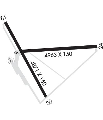
Airport Diagram might not be current.
|
| Facility Name: | TANACROSS |
| City Name: | TANACROSS |
| County: | SOUTHEAST FAIRBANKS |
| State abbrev: | AK |
| State Name: | ALASKA |
| | |
| Ownership: | PUBLICLY OWNED |
| Use: | OPEN TO THE PUBLIC |
| Owner's Name: | BUREAU OF LAND MANAGEMENT; STEESE/WHITE MOUNTAIN DISTRICT. |
| Address: | 1150 UNIVERSITY AVE |
| | FAIRBANKS, AK 99709-3844 |
| Owner's Phone: | 907-474-2200 |
| | |
| Manager's Name: | LANORE HEPPLER |
| Address: | 1150 UNIVERSITY AVE. |
| | FAIBANKS, AK 99709 |
| Phone: | (907) 474-2320 |
| | |
| FAA Region: | ALASKA |
| FAA Field Office: | NONE |
Runway Identifications
Runway Identification: 06/24Length: 4963 ft
Width: 150 ft
Surface: ASPHALT-POOR CONDITION
Edge lights:
| | Runway: 06 | | Runway: 24 |
| Mag heading: | N/A | Mag heading: | N/A |
| Rwy Slope: | .14% Up | Rwy Slope: | -.14% Down |
| Approach: | | Approach: | |
| Pattern: | Left Traffic | Pattern: | Left Traffic |
| Markings: | NONSTANDARD | Markings: | NONSTANDARD |
| Marking Condition: | POOR; MARKINGS FADED. | Marking Condition: | POOR; MARKINGS FADED. |
| Arresting Dev: | | Arresting Dev: | |
| Lat & Long: | N6322.5 W14320.2 | Lat. & Long.: | N6322.5 W14318.4 |
| Elev: | 1547.0 ft. MSL | Elev: | 1554.0 ft. MSL |
| TCH: | | TCH: | |
| Visual Glide Path: | | Visual Glide Path: | |
| Displaced Threshold: | No | Displaced Threshold: | No |
| Touchdown Zone: | YES | Touchdown Zone: | YES |
| Touchdown Elev.: | 1549.0 feet | Touchdown Elev.: | 1548.0 feet |
| Visual Glide Slope: | | Visual Glide Slope: | |
| RVR Equipment: | | RVR Equipment: | |
| RVV Equipment: | NO | RVV Equipment: | NO |
| Approach Lights: | | Approach Lights: | |
| REIL: | NO | REIL: | NO |
| Centerline Lights: | NO | Centerline Lights: | NO |
| Touchdown lights: | NO | Touchdown lights: | NO |
| Runway Category: | Runway with a Visual Approach | Runway Category: | Runway with a Visual Approach |
| Declared Distances: | | Declared Distances: | |
| Obstructions: | TREES | Obstructions: | TREES |
| Marked: | NOT Marked/Lighted | Marked: | NOT Marked/Lighted |
| Clearance slope: | 11:1 | Clearance slope: | |
| Obstruction height: | 50 feet AGL | Obstruction height: | 47 feet AGL |
| Dist. from runway: | 799 feet | Dist. from runway: | 200 feet |
| Centerline offset: | 325 right of centerline | Centerline offset: | 230 feet right of centerline |
| Comments: | | Comments: | |
Runway Identification: 12/30Length: 4871 ft
Width: 150 ft
Surface: ASPHALT-POOR CONDITION
Edge lights:
| | Runway: 12 | | Runway: 30 |
| Mag heading: | N/A | Mag heading: | N/A |
| Rwy Slope: | .31% Up | Rwy Slope: | -.31% Down |
| Approach: | | Approach: | |
| Pattern: | Left Traffic | Pattern: | Left Traffic |
| Markings: | NONSTANDARD | Markings: | NONSTANDARD |
| Marking Condition: | POOR; MARKINGS FADED. | Marking Condition: | POOR; MARKINGS FADED. |
| Arresting Dev: | | Arresting Dev: | |
| Lat & Long: | N6322.7 W14320.6 | Lat. & Long.: | N6322.1 W14319.7 |
| Elev: | 1544.0 ft. MSL | Elev: | 1559.0 ft. MSL |
| TCH: | | TCH: | |
| Visual Glide Path: | | Visual Glide Path: | |
| Displaced Threshold: | No | Displaced Threshold: | No |
| Touchdown Zone: | NO | Touchdown Zone: | NO |
| Touchdown Elev.: | | Touchdown Elev.: | |
| Visual Glide Slope: | | Visual Glide Slope: | |
| RVR Equipment: | | RVR Equipment: | |
| RVV Equipment: | NO | RVV Equipment: | NO |
| Approach Lights: | | Approach Lights: | |
| REIL: | NO | REIL: | NO |
| Centerline Lights: | NO | Centerline Lights: | NO |
| Touchdown lights: | NO | Touchdown lights: | NO |
| Runway Category: | Runway with a Visual Approach | Runway Category: | Runway with a Visual Approach |
| Declared Distances: | | Declared Distances: | |
| Obstructions: | TREES | Obstructions: | TREES |
| Marked: | NOT Marked/Lighted | Marked: | NOT Marked/Lighted |
| Clearance slope: | 9:1 | Clearance slope: | |
| Obstruction height: | 52 feet AGL | Obstruction height: | 31 feet AGL |
| Dist. from runway: | 690 feet | Dist. from runway: | 200 feet |
| Centerline offset: | | Centerline offset: | 120 feet right of centerline |
| Comments: | RY 12 ROAD CROSSES APCH 60 FT FM THR & RIVER CROSSES APCH 100 FT FM RY END. | Comments: | RWY 30 HAS 41 FT TREE 108 FT FROM RWY END & 169 FT LEFT AND RIGHT. |

