Click here for more info on on SMS!

KTRL

TERRELL MUNI
TERRELL
TX
Time Zone: Central
Lat: N 3242.5
Long: W 09616.0
Elev: 474
Var: -04
Longest Runway: 5006
AWOS: 119.27
CTAF: 123.07

FBO & Flight Services info for KTRL

FBOs: Update your Fuel Prices

TERRELL AVIATIONPh: 972-524-1601 Fax: 972-563-5304 Freq: 122.8
Service
Jet
100LL
SAF
MoGas
Fuel Avail: PRIST PREMIXED
Full4.504.90    Last Update: 03/27/2024 14:34

Self        
 Address: 3 SILENT WINGS BLVD.,   TERRELL, TX 75160
ASOSPh: 972-551-1334
-
Freq: 119.27  
If you are an FBO, call 1-203-262-1700 to update your info or email: FltPlan.Advertising@garmin.com
Advertise your FBO on FltPlan.com

Runway & Approach Info for KTRL
Rwy
Length
Land Dist**
Approach*
  Rwy
Length
Land Dist**
Approach*
18
5006x75  5006'          
 
  
36
  5006x75  5006'          
 
 * only ILS, LOC, LDA, and SDF approaches to a specific runway are shown
** For any Declared Landing Distance Available, please see A/FD or Approach plates
Runway Weight Capability (lbs.) Help
Runway IDSingle WheelDouble WheelDouble Tandem WheelDual Double Wheel
18/3630,000N/AN/AN/A
These numbers are Advisory and are not limits.   The Airport Manager should have more accurate Weight Limits
Approach Charts
Approaches    
Current Weather/Notams
Customs Information Send updates to Support@FltPlan.com
Customs Not Available
Database effective 04/18/2024
Airport Diagram of KTRL
Airport Diagram might not be current.

Facility Name: TERRELL MUNI
City Name: TERRELL
County: KAUFMAN
State abbrev: TX
State Name: TEXAS
   
Ownership: PUBLICLY OWNED
Use: OPEN TO THE PUBLIC
Owner's Name: CITY OF TERRELL
Address: 201 EAST NASH
 TERRELL, TX 75160
Owner's Phone: (972) 551-6600
  
Manager's Name: GLENN CALDWELL
Address: 400 INDUSTRIAL BLVD.
 TERRELL, TX 75160
Phone: (972) 551-6614
   
FAA Region: SOUTHWEST
FAA Field Office: TEX


Sunrise / Sunset times for TERRELL MUNI

DateSunriseSunset
04/16/24 Tuesday6:5319:56
04/17/24 Wednesday6:5219:57
04/18/24 Thursday6:5119:58
04/19/24 Friday6:5019:59
04/20/24 Saturday6:4919:59
04/21/24 Sunday6:4820:00
04/22/24 Monday6:4720:01
04/23/24 Tuesday6:4520:01
04/24/24 Wednesday6:4420:02
04/25/24 Thursday6:4320:03
04/26/24 Friday6:4220:04
04/27/24 Saturday6:4120:04
04/28/24 Sunday6:4020:05
04/29/24 Monday6:3920:06

Airport Facilities

Airport Attendance Schedule7 Days A Week 0800-2000; FOR ATTENDANT AFT HRS CALL 972-835-5395/5408.
Airport Status OPERATIONAL (This Status can change at any time - please check NOTAMS)
Airport Lighting ScheduleMIRL RWY 18/36 PRESET LOW INTST; TO INCR INTST & ACTVT RLLS RWY 18; PAPI RWYS 18 & 36 - CTAF.
Airport Storage AvailableTie Downs, Hanger
Extra Services AvailableFlight Instruction, Aircraft Rental, Aircraft Sales, Annual Surveying
Wind IndicatorYES - (lighted)
Control TowerNO
CTAF Frequency123.075
Unicom Frequency123.075
Rotating Beacon ColorWG
Segmented CircleYES
Landing FeeNO

Airport Inspection Data

Airport InspectedSTATE - performed by PRIVATE CONTRACT PERSONNEL
Inspection Date09/23/2022

Airport Services

Type of Fuel AvailableGrade 100LL, JET A (freeze point -40C)
Airframe Repair ServiceMAJOR
Power Plant Repair ServiceMAJOR

Geographic Data

LatitudeN3242.5
LongitudeW09616.0 (ESTIMATED)
Arpt Elevation474ft (SURVEYED)
Magnetic Variation04E
1 miles SEof TERRELL
Traffic Pattern Altitude
Sectional ChartDALLAS-FT WORTH

Aircraft Data

Operations (Reported)YearlyAvg. Daily
General Aviation Transient 840023
General Aviation Local 2520069
Air Taxi 500
Commerical 00
Commuter 00
Military 00
Aircraft based on Field
General Aviation Singles 74
General Aviation Multi 9
Jet Aircraft 0
General Aviation Helicopters 0
Military Aircraft 0
Gliders 0
Ultralights 0

FAA Services

FSS on field NO
FSS tie-in FORT WORTH
FSS Phone 1-800-WX-BRIEF
Who issues Notams TRL
Notam D service at airport YES
ARTCC Name FORT WORTH

Federal Status

Airport Certification
Aircraft Rescue & Firefighting IndexNone
Airport of EntryNo
Custom Landing RightsNo
Joint Civil/MilitaryNo
Military Landing rightsYES

Federal Agreements

NATIONAL PLAN OF INTEGRATED AIRPORT SYSTEMS (NPIAS)
GRANT AGREEMENTS UNDER FAAP/ADAP/AIP
SURPLUS PROPERTY AGREEMENT UNDER REGULATION 16-WAA
ASSURANCES PURSUANT TO TITLE VI, CIVIL RIGHTS ACT OF 1964

Remarks

BIRDS ON AND INVOF ARPT.
FOR CD CTC FORT WORTH ARTCC AT 817-858-7584.
Airport Communications & Frequencies:
CTAF Frequency:
123.075
Unicom Frequency:
123.075
Remarks
  • APCH/DEP CTL SVC PRVDD BY FORT WORTH ARTCC (ZFW) ON FREQS 132.025/360.75 (CUMBY RCAG).
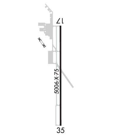
  • Runway Identifications
    Runway Identification: 18/36
    Length: 5006 ft
    Width: 75 ft
    Surface: ASPHALT-GOOD CONDITION
    Edge lights: Medium Intensity

    Treatment: NONE

     Runway: 18   Runway: 36
    Mag heading: 176°Mag heading: 356°
    Rwy Slope: -.36% DownRwy Slope: .36% Up
    Approach: Approach:
    Pattern: Left TrafficPattern: Left Traffic
    Markings: NONPRECISION INSTRUMENTMarkings: NONPRECISION INSTRUMENT
    Marking Condition: GOODMarking Condition: GOOD
    Arresting Dev: Arresting Dev:
    Lat & Long: N3242.9  W09616.0Lat. & Long.: N3242.1  W09616.0
    Elev: 474.1 ft. MSLElev: 456.1 ft. MSL
    TCH: 32 ft. AGLTCH: 31 ft. AGL
    Visual Glide Path: 3.00 degreesVisual Glide Path: 3.00 degrees
    Displaced Threshold: NoDisplaced Threshold: No
    Touchdown Zone: YESTouchdown Zone: YES
    Touchdown Elev.: 474.1 feetTouchdown Elev.: 472.0 feet
    Visual Glide Slope: 4-Light PAPI on LEFT side of RunwayVisual Glide Slope: 4-Light PAPI on RIGHT side of Runway
    RVR Equipment: RVR Equipment:
    RVV Equipment: NORVV Equipment: NO
    Approach Lights: RLLSApproach Lights:
    REIL: YESREIL: YES
    Centerline Lights: NOCenterline Lights: NO
    Touchdown lights: NOTouchdown lights: NO
    Runway Category: Runway with a Non-precision Approach having visibility minimums greater than 3/4 mileRunway Category: Runway with a Non-precision Approach having visibility minimums greater than 3/4 mile
    Declared Distances: Declared Distances:
    Obstructions: TREESObstructions: TREES
    Marked: NOT Marked/LightedMarked: NOT Marked/Lighted
    Clearance slope: 16:1Clearance slope: 25:1
    Obstruction height: 60 feet AGLObstruction height: 40 feet AGL
    Dist. from runway: 1175 feetDist. from runway: 1225 feet
    Centerline offset: 327 right of centerlineCenterline offset: 445 feet right of centerline
    Comments: Comments:
    C:4/P: