Click here for more info on on SMS!

KTQH

TAHLEQUAH MUNI
TAHLEQUAH
OK
Time Zone: Central
Lat: N 3555.8
Long: W 09500.3
Elev: 874
Var: -05
Longest Runway: 5001
AWOS: 118.42
CTAF: 122.8

FBO & Flight Services info for KTQH

FBOs: Update your Fuel Prices
Providing high quality fuel and services to you and your customers, from Phillips 66 Aviation.
Ph: 918-431-4139 Fax: 918-431-4139 Freq: 122.8WebsiteE-Mail
Service
Jet
100LL
SAF
MoGas
Fuel Avail: PRIST PREMIXED
Full5.155.35    Last Update: 05/04/2024 13:11

Self        
Misc. Info: Address: 2100 AIRPORT PARKWAY,   TAHLEQUAH, OK 74464

AWOSPh: 918-453-2729
-
Freq: 118.42  
If you are an FBO, call 1-203-262-1700 to update your info or email: FltPlan.Advertising@garmin.com
Advertise your FBO on FltPlan.com

Runway & Approach Info for KTQH
Rwy
Length
Land Dist**
Approach*
  Rwy
Length
Land Dist**
Approach*
17
5001x75  5001'          
 
  
35
  5001x75  5001'          
 
 * only ILS, LOC, LDA, and SDF approaches to a specific runway are shown
** For any Declared Landing Distance Available, please see A/FD or Approach plates
Runway Weight Capability (lbs.) Help
Runway IDSingle WheelDouble WheelDouble Tandem WheelDual Double Wheel
17/3526,000N/AN/AN/A
These numbers are Advisory and are not limits.   The Airport Manager should have more accurate Weight Limits
Approach Charts
Approaches    
Current Weather/Notams
Customs Information Send updates to Support@FltPlan.com
Customs Not Available
Database effective 05/16/2024
Airport Diagram of KTQH
Airport Diagram might not be current.

Facility Name: TAHLEQUAH MUNI
City Name: TAHLEQUAH
County: CHEROKEE
State abbrev: OK
State Name: OKLAHOMA
   
Ownership: PUBLICLY OWNED
Use: OPEN TO THE PUBLIC
Owner's Name: CITY OF TAHLEQUAH
Address: CITY HALL, 111 S. CHEROKEE
 TAHLEQUAH, OK 74464
Owner's Phone: 918-456-0561
  
Manager's Name: BRIAN LAMBERT
Address: 2100 AIRPORT PARKWAY
 TAHLEQUAH, OK 74464
Phone: (918) 708-5600
   
FAA Region: SOUTHWEST
FAA Field Office: AOK


Sunrise / Sunset times for TAHLEQUAH MUNI

DateSunriseSunset
05/07/24 Tuesday6:2120:13
05/08/24 Wednesday6:2020:14
05/09/24 Thursday6:1920:15
05/10/24 Friday6:1820:15
05/11/24 Saturday6:1720:16
05/12/24 Sunday6:1620:17
05/13/24 Monday6:1520:18
05/14/24 Tuesday6:1520:19
05/15/24 Wednesday6:1420:19
05/16/24 Thursday6:1320:20
05/17/24 Friday6:1220:21
05/18/24 Saturday6:1220:22
05/19/24 Sunday6:1120:23
05/20/24 Monday6:1020:23

Airport Facilities

Airport Attendance ScheduleMON-FRI 0800-1700
Airport Status OPERATIONAL (This Status can change at any time - please check NOTAMS)
Airport Lighting ScheduleACTVT REIL RWY 17 & 35; MIRL RWY 17/35 - CTAF. PAPI RWY 17 & 35 ON CONSLY.
Airport Storage AvailableTie Downs, Hanger
Extra Services AvailableAircraft Rental
Wind IndicatorYES - (unlit)
Control TowerNO
CTAF Frequency122.800
Unicom Frequency122.800
Rotating Beacon ColorWG
Segmented CircleYES
Landing FeeNO

Airport Inspection Data

Airport InspectedSTATE - performed by STATE AERONAUTICAL PERSONNEL
Inspection Date09/30/2021

Airport Services

Type of Fuel AvailableGrade 100LL, JET A (freeze point -40C)
Airframe Repair ServiceMINOR
Power Plant Repair ServiceMINOR

Geographic Data

LatitudeN3555.8
LongitudeW09500.3 (ESTIMATED)
Arpt Elevation874ft (SURVEYED)
Magnetic Variation05E
2 miles NWof TAHLEQUAH
Traffic Pattern Altitude
Sectional ChartDALLAS-FT WORTH

Aircraft Data

Operations (Reported)YearlyAvg. Daily
General Aviation Transient 670018
General Aviation Local 870024
Air Taxi 00
Commerical 00
Commuter 00
Military 00
Aircraft based on Field
General Aviation Singles 34
General Aviation Multi 2
Jet Aircraft 1
General Aviation Helicopters 0
Military Aircraft 0
Gliders 0
Ultralights 0

FAA Services

FSS on field NO
FSS tie-in MC ALESTER
FSS Phone 1-800-WX-BRIEF
Who issues Notams TQH
Notam D service at airport YES
ARTCC Name MEMPHIS

Federal Status

Airport Certification
Aircraft Rescue & Firefighting IndexNone
Airport of EntryNo
Custom Landing RightsNo
Joint Civil/MilitaryNo
Military Landing rightsYES

Federal Agreements

NATIONAL PLAN OF INTEGRATED AIRPORT SYSTEMS (NPIAS)
GRANT AGREEMENTS UNDER FAAP/ADAP/AIP
ASSURANCES PURSUANT TO TITLE VI, CIVIL RIGHTS ACT OF 1964

Remarks

FOR CD CTC MEMPHIS ARTCC AT 901-368-8453/8449.
Airport Communications & Frequencies:
CTAF Frequency:
122.800
Unicom Frequency:
122.800
Remarks
  • APCH/DEP SVC PRVDD BY MEMPHIS ARTCC ON FREQS 126.1/269.0 (FAYETTEVILLE RCAG).
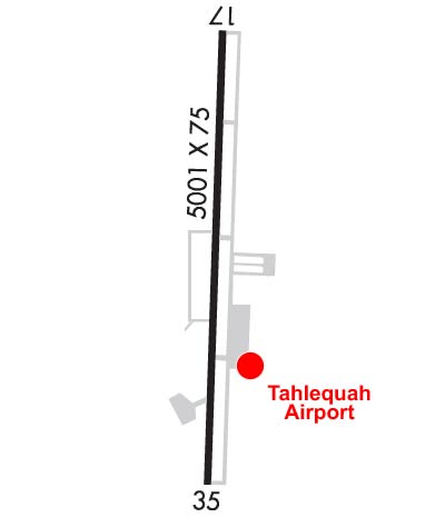
  • Runway Identifications
    Runway Identification: 17/35
    Length: 5001 ft
    Width: 75 ft
    Surface: ASPHALT-GOOD CONDITION
    Edge lights: Medium Intensity

    Treatment: NONE

     Runway: 17   Runway: 35
    Mag heading: 177°Mag heading: 357°
    Rwy Slope: -.36% DownRwy Slope: .36% Up
    Approach: Approach:
    Pattern: Left TrafficPattern: Left Traffic
    Markings: NONPRECISION INSTRUMENTMarkings: NONPRECISION INSTRUMENT
    Marking Condition: GOODMarking Condition: GOOD
    Arresting Dev: Arresting Dev:
    Lat & Long: N3556.2  W09500.3Lat. & Long.: N3555.4  W09500.3
    Elev: 869.4 ft. MSLElev: 851.2 ft. MSL
    TCH: 39 ft. AGLTCH: 39 ft. AGL
    Visual Glide Path: 3.50 degreesVisual Glide Path: 3.00 degrees
    Displaced Threshold: NoDisplaced Threshold: No
    Touchdown Zone: YESTouchdown Zone: YES
    Touchdown Elev.: 874.1 feetTouchdown Elev.: 874.0 feet
    Visual Glide Slope: 4-Light PAPI on LEFT side of RunwayVisual Glide Slope: 4-Light PAPI on LEFT side of Runway; PAPI UNUSBL BYD 8 DEGS RIGHT OF CNTRLN.
    RVR Equipment: RVR Equipment:
    RVV Equipment: NORVV Equipment: NO
    Approach Lights: Approach Lights:
    REIL: YESREIL: YES
    Centerline Lights: NOCenterline Lights: NO
    Touchdown lights: NOTouchdown lights: NO
    Runway Category: Runway with a Non-precision Approach having visibility minimums greater than 3/4 mileRunway Category: Runway with a Non-precision Approach having visibility minimums greater than 3/4 mile
    Declared Distances: Declared Distances:
    Obstructions: TREESObstructions: TREES
    Marked: NOT Marked/LightedMarked: NOT Marked/Lighted
    Clearance slope: 15:1Clearance slope: 2:1
    Obstruction height: 34 feet AGLObstruction height: 19 feet AGL
    Dist. from runway: 719 feetDist. from runway: 240 feet
    Centerline offset: 150 right of centerlineCenterline offset: 112 feet left of centerline
    Comments: Comments: 18 FT TREE 185 FT FM RWY END 120 FT L OF CNTRLN.
    C:2/P: