KTPF

PETER O KNIGHT
TAMPA
FL
Time Zone: Eastern
Lat: N 2754.9
Long: W 08227.0
Elev: 7
Var: +05
Longest Runway: 3583
Clr Del: 119.8
AWOS: 118.92
CTAF: 122.72

FBO & Flight Services info for KTPF

FBOs: Update your Fuel Prices

  click here  
Professional Avionics Installation, Service and Repair. Our Tampa facility is located on Davis Island at the beautiful Peter O. Knight Airport. This facility offers full-service aircraft maintenance in addition to avionics service, installation and repair. Sarasota Avionics is the exclusive Cirrus Service Center for the Tampa area.
Ph: 941-484-9410 Fax: 941-360-6878
-
WebsiteE-Mail
                          
Service
Jet
100LL
SAF
MoGas
Fuel Avail: ~~
Full        Last Update: 04/24/2024 06:02:16

Self        
Misc. Info: Toll-free: 1-888-289-0997 Ext. 139Address: 845 SEVERN AVENUE   TAMPA, FL 33606

ATLAS AVIATIONPh: 813-251-1752 Fax: 813-251-0731 Freq: 122.72
Service
Jet
100LL
SAF
MoGas
Full7.307.34    Caution: Fuel prices have not been updated in 31 days.   Last Update: 03/24/2024 11:19  
Self        
 Address: 825 SEVERN AVENUE   TAMPA, FL 33606
AWOSPh: 813-251-6824
-
Freq: 118.92  
If you are an FBO, call 1-203-262-1700 to update your info or email: FltPlan.Advertising@garmin.com
Advertise your FBO on FltPlan.com

Runway & Approach Info for KTPF
Rwy
Length
Land Dist**
Approach*
  Rwy
Length
Land Dist**
Approach*
04
3583x100  3404'          
 
  
22
  3583x100  3403'          
 
18
2687x75  2484'          
 
  
36
  2687x75  2486'          
 
 * only ILS, LOC, LDA, and SDF approaches to a specific runway are shown
** For any Declared Landing Distance Available, please see A/FD or Approach plates
Runway Weight Capability (lbs.) Help
Runway IDSingle WheelDouble WheelDouble Tandem WheelDual Double Wheel
04/2275,000108,000N/AN/A
18/3627,00042,000N/AN/A
These numbers are Advisory and are not limits.   The Airport Manager should have more accurate Weight Limits
Approach Charts
Approaches    
Current Weather/Notams
Customs Information Send updates to Support@FltPlan.com
Customs Not Available
Database effective 05/16/2024
Airport Diagram of KTPF
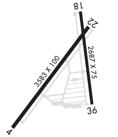
Airport Diagram might not be current.

Facility Name: PETER O KNIGHT
City Name: TAMPA
County: HILLSBOROUGH
State abbrev: FL
State Name: FLORIDA
   
Ownership: PUBLICLY OWNED
Use: OPEN TO THE PUBLIC
Owner's Name: HILLSBOROUGH COUNTY AVIATION AUTH; JOHN TILIACOS
Address: PO BOX 22287
 TAMPA, FL 33622
Owner's Phone: (813) 870-8776; 813-251-1752
  
Manager's Name: BRETT FAY
Address: PO BOX 22287
 TAMPA, FL 33606
Phone: (813) 870-8735
   
FAA Region: SOUTHERN
FAA Field Office: ORL


Sunrise / Sunset times for PETER O KNIGHT

DateSunriseSunset
04/23/24 Tuesday6:5620:00
04/24/24 Wednesday6:5520:01
04/25/24 Thursday6:5520:01
04/26/24 Friday6:5420:02
04/27/24 Saturday6:5320:02
04/28/24 Sunday6:5220:03
04/29/24 Monday6:5120:03
04/30/24 Tuesday6:5020:04
05/01/24 Wednesday6:4920:05
05/02/24 Thursday6:4920:05
05/03/24 Friday6:4820:06
05/04/24 Saturday6:4720:06
05/05/24 Sunday6:4620:07
05/06/24 Monday6:4620:07

Airport Facilities

Airport Attendance Schedule7 Days A Week 0700-1900
Airport Status OPERATIONAL (This Status can change at any time - please check NOTAMS)
Airport Lighting ScheduleACTVT REIL RWY 22; PAPI RWY 04 & 36; MIRL RWY 04/22 & 18/36 - CTAF.
Airport Storage AvailableTie Downs, Hanger
Extra Services AvailableAvionics, Charter, Flight Instruction, Aircraft Rental
Wind IndicatorYES - (lighted)
Control TowerNO
CTAF Frequency122.725
Unicom Frequency122.725
Rotating Beacon ColorWG
Segmented CircleY-L
Landing FeeNO

Airport Inspection Data

Airport InspectedSTATE - performed by STATE AERONAUTICAL PERSONNEL
Inspection Date11/15/2023

Airport Services

Type of Fuel AvailableGrade 100LL, JET A (freeze point -40C)
Airframe Repair ServiceMAJOR
Power Plant Repair ServiceMAJOR

Geographic Data

LatitudeN2754.9
LongitudeW08227.0 (ESTIMATED)
Arpt Elevation7ft (SURVEYED)
Magnetic Variation05W
3 miles Sof TAMPA
Traffic Pattern Altitude900
Sectional ChartMIAMI

Aircraft Data

Operations (Reported)YearlyAvg. Daily
General Aviation Transient 2900079
General Aviation Local 2100058
Air Taxi 380010
Commerical 00
Commuter 00
Military 00
Aircraft based on Field
General Aviation Singles 87
General Aviation Multi 8
Jet Aircraft 0
General Aviation Helicopters 5
Military Aircraft 0
Gliders 0
Ultralights 0

FAA Services

FSS on field NO
FSS tie-in SAINT PETERSBURG
FSS Phone 1-800-WX-BRIEF
Who issues Notams TPF
Notam D service at airport YES
ARTCC Name MIAMI

Federal Status

Airport Certification
Aircraft Rescue & Firefighting IndexNone
Airport of EntryNo
Custom Landing RightsNo
Joint Civil/MilitaryNo
Military Landing rightsYES

Federal Agreements

NATIONAL PLAN OF INTEGRATED AIRPORT SYSTEMS (NPIAS)
GRANT AGREEMENTS UNDER FAAP/ADAP/AIP
ASSURANCES PURSUANT TO TITLE VI, CIVIL RIGHTS ACT OF 1964

Remarks

OCEAN VESSEL SHIP CHANNEL EAST.
GULLS ON AND INVOF ARPT.
TWY E CLSD TO ACFT WITH WING SPANS IN EXCESS OF 40 FT.
ALERT: MACDILL AFB LCTD 4 MILES SW & HOSP HEL TFC 1 NM NORTH USING UNICOM 122.825.
FOR CD CTC TAMPA APCH AT 813-878-2528
RWY 18 SHIP CHANNEL APCH END.
RWY 22 SHIP CHANNEL APCH END.
Airport Communications & Frequencies:
Clearance Delivery Frequencies:
119.8 IFR
CTAF Frequency:
122.725
Unicom Frequency:
122.725
TAMPA Primary Approach Frequencies:  
119.9
290.3
TAMPA Primary Departure Frequencies:  
119.9
290.3
Runway Identifications
Runway Identification: 04/22
Length: 3583 ft
Width: 100 ft
Surface: ASPHALT-GOOD CONDITION
Edge lights: Medium Intensity

Treatment: NONE
Weight: PCN 26 /F/A/X/T

 Runway: 04   Runway: 22
Mag heading: 42°Mag heading: 222°
Rwy Slope: -.03% DownRwy Slope: .03% Up
Approach: Approach:
Pattern: Right TrafficPattern: Left Traffic
Markings: NONPRECISION INSTRUMENTMarkings: NONPRECISION INSTRUMENT
Marking Condition: GOODMarking Condition: GOOD
Arresting Dev: Arresting Dev:
Lat & Long: N2754.7  W08227.2Lat. & Long.: N2755.1  W08226.8
Elev: 6.9 ft. MSLElev: 6.0 ft. MSL
TCH: 45 ft. AGLTCH:
Visual Glide Path: 3.50 degreesVisual Glide Path:
Displaced Threshold: 179 feetDisplaced Threshold: 180 feet
Touchdown Zone: YESTouchdown Zone: YES
Touchdown Elev.: 7.0 feetTouchdown Elev.: 6.8 feet
Visual Glide Slope: 4-Light PAPI on LEFT side of RunwayVisual Glide Slope:
RVR Equipment: RVR Equipment:
RVV Equipment: NORVV Equipment: NO
Approach Lights: Approach Lights:
REIL: NOREIL: YES
Centerline Lights: NOCenterline Lights: NO
Touchdown lights: NOTouchdown lights: NO
Runway Category: Runway with a Visual ApproachRunway Category: Runway with a Non-precision Approach
Declared Distances: TORA:3403' TODA:3403' ASDA:3403' LDA:3224'Declared Distances: TORA:3404' TODA:3404' ASDA:3404' LDA:3403'
Obstructions: FENCEObstructions: BOAT
Marked: LIGHTEDMarked: NOT Marked/Lighted
Clearance slope: 1:1; APCH RATIO 28:1 TO DTHR.Clearance slope: 7:1; RWY 22 APCH RATIO 26:1 TO THE DTHR.
Obstruction height: 6 feet AGLObstruction height: 30 feet AGL
Dist. from runway: 200 feetDist. from runway: 415 feet
Centerline offset: 222 right of centerlineCenterline offset: 170 feet right of centerline
Comments: 6 FT FENCE 200 FT FM RWY END 222 FT R.Comments:
Runway Identification: 18/36
Length: 2687 ft
Width: 75 ft
Surface: ASPHALT-FAIR CONDITION
Edge lights: Medium Intensity

Treatment: NONE
Weight: PCN 8 /F/B/X/T

 Runway: 18   Runway: 36
Mag heading: 178°Mag heading: 358°
Rwy Slope: .01% UpRwy Slope: -.01% Down
Approach: Approach:
Pattern: Left TrafficPattern: Right Traffic
Markings: NONPRECISION INSTRUMENTMarkings: NONPRECISION INSTRUMENT
Marking Condition: GOODMarking Condition: GOOD
Arresting Dev: Arresting Dev:
Lat & Long: N2755.2  W08226.9Lat. & Long.: N2754.8  W08226.8
Elev: 5.9 ft. MSLElev: 6.3 ft. MSL
TCH: TCH: 34 ft. AGL
Visual Glide Path: Visual Glide Path: 3.00 degrees
Displaced Threshold: 203 feetDisplaced Threshold: 201 feet
Touchdown Zone: YESTouchdown Zone: YES
Touchdown Elev.: 7.4 feetTouchdown Elev.: 7.4 feet
Visual Glide Slope: Visual Glide Slope: 2-Light PAPI on RIGHT side of Runway
RVR Equipment: RVR Equipment:
RVV Equipment: NORVV Equipment: NO
Approach Lights: Approach Lights:
REIL: NOREIL: NO
Centerline Lights: NOCenterline Lights: NO
Touchdown lights: NOTouchdown lights: NO
Runway Category: Runway with a Visual ApproachRunway Category: Runway with a Non-precision Approach
Declared Distances: TORA:2687' TODA:2687' ASDA:2574' LDA:2371'Declared Distances: TORA:2487' TODA:2487' ASDA:2512' LDA:2311'
Obstructions: FENCEObstructions: FENCE
Marked: LIGHTEDMarked: LIGHTED
Clearance slope: 1:1; APCH RATIO 20:1 TO DTHR.Clearance slope: 1:1; APCH RATIO 25:1 TO DTHR.
Obstruction height: 6 feet AGLObstruction height: 5 feet AGL
Dist. from runway: 200 feetDist. from runway: 200 feet
Centerline offset: 93 right of centerlineCenterline offset: 150 feet left of centerline
Comments: RWY 18 HAS 6 FT FENCE AND 15 FT ROAD 200 FT FM RWY END 93 FT RIGHT.Comments: RWY 36 HAS 5 FT FENCE AND 15 FT ROAD 200 FT FM RWY END 150 FT L.
C:21/P: