Click here for more info on on SMS!

KTPA

Whisper PlateWhisper Track
TAMPA INTL
TAMPA
FL
Time Zone: Eastern
Lat: N 2758.5
Long: W 08232.0
Elev: 26
Var: +05
Longest Runway: 11002
Clr Del: 133.6
Dept. ATIS: 128.47
Arr. ATIS: 126.45
Ground: 121.35/121.7
Tower: 119.05/119.5

FBO & Flight Services info for KTPA

FBOs: Update your Fuel Prices
Uniting exceptional customer service and uncompromising safety standards, we want to be your first choice for business aviation services. For an unsurpassed customer experience, fly with Signature Flight Support.
Ph: 813-870-3813 Fax: 813-877-5739 Freq: 130.00WebsiteE-Mail
                                       
Service
Jet
100LL
SAF
MoGas
Fuel Avail: Prist + $0.08/gal
Full7.407.66    Last Update: 04/24/2024 09:41

Self        
Misc. Info: Address: 2450 N. WESTSHORE BLVD.,   TAMPA, FLORIDA 33607

  click here  
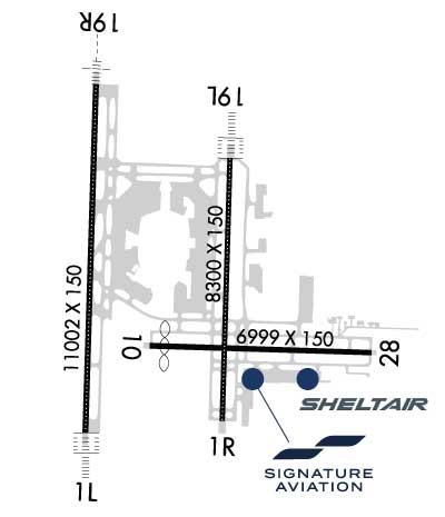
Fly in to experience the renowned care and individualized attention you can only get at Sheltair TPA. Services include: U.S. Customs, large canopy, ramp access for passenger vehicles, superior groundsupport/concierge services, complimentary interior cleaning, catering, crew cars, canteen market/complimentary refreshments, executive conference rooms, passenger lounges, & crew lounge with showers.
Ph: 813-319-8000 Fax: 813-319-8080 Freq: 130.6WebsiteE-Mail
                     
Service
Jet
100LL
SAF
MoGas
Fuel Avail: Open 24/7. Prist+ $0.12/gal
Full7.778.27    Last Update: 04/22/2024 12:50

Self        
Misc. Info: Please call us for volume discount schedule.Address: 4751 JIM WALTER BLVD.,   TAMPA, FL 33607

NOISE RESTRICTPh: 813-870-8700
-
-
 
ASOSPh: 813-873-7228
-
-
 
If you are an FBO, call 1-203-262-1700 to update your info or email: FltPlan.Advertising@garmin.com
Advertise your FBO on FltPlan.com

Runway & Approach Info for KTPA
Rwy
Length
Land Dist**
Approach*
  Rwy
Length
Land Dist**
Approach*
01L
11002x150  11002'          
ILS/DME
 108.90 - 006°  
  
19R
  11002x150  11002'          
ILS/DME
 108.50 - 186°  
01R
8300x150  8300'          
LOC/DME
 111.95 - 006°  
  
19L
  8300x150  8300'          
ILS/DME
 110.30 - 186°  
10
6999x150  6501'          
 
  
28
  6999x150  6999'          
 
 * only ILS, LOC, LDA, and SDF approaches to a specific runway are shown
** For any Declared Landing Distance Available, please see A/FD or Approach plates
Runway Weight Capability (lbs.) Help
Runway IDSingle WheelDouble WheelDouble Tandem WheelDual Double Wheel
01L/19R60,000210,000358,000850,000
01R/19L60,000210,000358,000850,000
10/2875,000200,000280,000380,000
These numbers are Advisory and are not limits.   The Airport Manager should have more accurate Weight Limits
Approach Charts
Approaches    
Current Weather/Notams
Customs Information Send updates to Support@FltPlan.com
Phone 813-676-4590
Fax 813-676-4575

Comments Mon-Fri 0830-1700 *2 hr advance notice required before entering US airspace *Maximum passengers per flight: 18 *Prior notification required. *Call prior to 1700 on preceding weekday. Weekend arrivals and after hours Phone 813-348-1700 ext 2400
Database effective 05/16/2024
Airport Diagram of KTPA
Airport Diagram might not be current.

Facility Name: TAMPA INTL
City Name: TAMPA
County: HILLSBOROUGH
State abbrev: FL
State Name: FLORIDA
   
Ownership: PUBLICLY OWNED
Use: OPEN TO THE PUBLIC
Owner's Name: HILLSBOROUGH CO AVN AUTHORITY
Address: PO BOX 22287
 TAMPA, FL 33622
Owner's Phone: 813-870-8700
  
Manager's Name: JOHN TILIACOS
Address: PO BOX 22287
 TAMPA, FL 33622
Phone: 813-870-8700; 813-870-8752
   
FAA Region: SOUTHERN
FAA Field Office: ORL


Sunrise / Sunset times for TAMPA INTL

DateSunriseSunset
04/23/24 Tuesday6:5720:00
04/24/24 Wednesday6:5620:01
04/25/24 Thursday6:5520:02
04/26/24 Friday6:5420:02
04/27/24 Saturday6:5320:03
04/28/24 Sunday6:5220:03
04/29/24 Monday6:5120:04
04/30/24 Tuesday6:5020:04
05/01/24 Wednesday6:5020:05
05/02/24 Thursday6:4920:06
05/03/24 Friday6:4820:06
05/04/24 Saturday6:4720:07
05/05/24 Sunday6:4720:07
05/06/24 Monday6:4620:08

Airport Facilities

Airport Attendance ScheduleCONTINUOUS
Airport Status OPERATIONAL (This Status can change at any time - please check NOTAMS)
Airport Lighting ScheduleSS-SR
Airport Storage AvailableTie Downs, Hanger
Extra Services AvailableAvionics, Cargo Handling, Charter
Wind IndicatorYES - (lighted)
Control TowerYES
CTAF Frequency
Unicom Frequency122.950
Rotating Beacon ColorWG
Segmented CircleYES
Landing FeeNO

Airport Inspection Data

Airport InspectedFEDERAL - performed by FAA AIRPORTS FIELD PERSONNEL
Inspection Date05/24/2023

Airport Services

Type of Fuel AvailableGrade 100LL, JET A (freeze point -40C)
Airframe Repair ServiceMAJOR
Power Plant Repair ServiceMAJOR

Geographic Data

LatitudeN2758.5
LongitudeW08232.0 (ESTIMATED)
Arpt Elevation26ft (SURVEYED)
Magnetic Variation05W
6 miles Wof TAMPA
Traffic Pattern Altitude
Sectional ChartMIAMI

Aircraft Data

Operations (Reported)YearlyAvg. Daily
General Aviation Transient 2816377
General Aviation Local 00
Air Taxi 2113758
Commerical 166433456
Commuter 00
Military 7712
Aircraft based on Field
General Aviation Singles 13
General Aviation Multi 5
Jet Aircraft 52
General Aviation Helicopters 6
Military Aircraft 0
Gliders 0
Ultralights 0

FAA Services

FSS on field NO
FSS tie-in SAINT PETERSBURG
FSS Phone 1-800-WX-BRIEF
Who issues Notams TPA
Notam D service at airport YES
ARTCC Name JACKSONVILLE

Federal Status

Airport CertificationAIRPORT RECEIVING SCHEDULED AIR CARRIER SERVICE FROM CARRIERS CERTIFICATED BY THE CIVIL AERONAUTICS BOARD
Aircraft Rescue & Firefighting IndexAIRPORT HAS A CERTIFICATE UNDER CFR PART 139
Airport of EntryYES
Custom Landing RightsNo
Joint Civil/MilitaryNo
Military Landing rightsYES

Federal Agreements

NATIONAL PLAN OF INTEGRATED AIRPORT SYSTEMS (NPIAS)
GRANT AGREEMENTS UNDER FAAP/ADAP/AIP
SURPLUS PROPERTY AGREEMENT UNDER PUBLIC LAW 289
SURPLUS PROPERTY AGREEMENT UNDER REGULATION 16-WAA
ASSURANCES PURSUANT TO TITLE VI, CIVIL RIGHTS ACT OF 1964

Remarks

RSTRS TO ADG IV OR LGR: TWY E1.
TXL K1 AND TXL K2 CLSD TO WINGSPANS GTR THAN 171 FT, TXL K1 AND TXL K2 CLSD WHILE WIDE BODY TXL K1W IS IN USE.
RWY 19L IS NOISE SENSITIVE TO TBJT DEPARTURES. RWY 01R IS NOISE SENSITIVE TO TBJT ARRIVALS. PUBLD NOISE ABATEMENT PROCS IN EFCT.
ONLY ACFT WITH PRIOR PMSN MAY USE TRML APN; ALL OTRS USE GA APN.
BIRD ACT ON AND INVOF ARPT.
RSTRS TO DESIGN GROUP V OR LGR; TWY J BTN TWY J1 AND TWY J2; TWY N WEST OF TWY L AND TWY E NORTH OF TWY J UNAVBL; TAXILANE Z CLSD TO WINGSPAN GTR THAN 171 FT - PPR ARPT OPS.
TWY F AND TWY R ARE NON-MOVEMENT AREAS. BOTH LOCATONS ARE UNAVBL FOR GROUP IV ACFT WITH A WINGSPAN GTR THAN 117 FT WO PPR FM ARPT OPS. TWY T PPR FROM ARPT OPS RQRD FOR ACFT WITH A WINGSPAN GTR THAN 90 FT.
TAXILANE G WEST OF TWY B1 CLSD TO WINGSPAN GTR THAN 118 FT - PPR APT OPS.
RWY 10/2 8 NOT NMLY AVBL TO OPNS OVER 75,000 LBS GWT.
RWY 10/2 8 RWY 10 FIRST 2600 FT CONC; RWY 28 FIRST 4400 FT ASPH.
Airport Communications & Frequencies:
ATIS Frequencies:   Hours(local) of Operation: CONTINUOUS
126.45 ;ARR
128.475 ;DEP
TAMPA Tower Frequencies:   Hours(local) of operation: CONTINUOUS   
119.05
119.5
269.4
TAMPA Ground Frequencies:
121.35
121.7
269.4
Clearance Delivery Frequencies:
133.6
Emergency Frequencies:
121.5
243.0
Unicom Frequency:
122.950
Remarks
  • TA31 ASR-6 REMOTED AT SARASOTA-BRADENTON ARPT.
  • TAMPA Primary Approach Frequencies:   Hours(local) of operation: CONTINUOUS   
    118.15 ;001-150
    118.5
    239.3 ;220-360
    279.6 ;001-150
    307.175
    353.575 ;151-219
    Part-time Approach Frequencies:  
    353.75
    TAMPA Primary Departure Frequencies:   Hours(local) of operation: CONTINUOUS   
    118.15 ;001-150
    118.8 ;220-360
    134.25 ;151-219
    239.3 ;220-360
    279.6 ;001-150
    307.175
    353.575 ;151-219
    Part-time Departure Frequencies:  
    353.75
    Class B Frequencies:
    119.65 ;151-219
    119.9 ;001-150
    125.3 ;220-360
    290.3 ;001-150
    316.05 ;220-360
    353.575 ;151-219
    Runway Identifications
    Runway Identification: 01L/19R
    Length: 11002 ft
    Width: 150 ft
    Surface: CONCRETE-GOOD CONDITION
    Edge lights: High Intensity

    Treatment: GROOVED
    Weight: PCN 85 /R/B/W/T

     Runway: 01L   Runway: 19R
    Mag heading: Mag heading: 187°
    Rwy Slope: .09% UpRwy Slope: -.09% Down
    Approach: ILS/DMEApproach: ILS/DME
    Pattern: Left TrafficPattern: Left Traffic
    Markings: PRECISION INSTRUMENTMarkings: PRECISION INSTRUMENT
    Marking Condition: GOODMarking Condition: GOOD
    Arresting Dev: Arresting Dev:
    Lat & Long: N2757.8  W08232.5Lat. & Long.: N2759.6  W08232.5
    Elev: 10.7 ft. MSLElev: 21.0 ft. MSL
    TCH: 71 ft. AGLTCH: 71 ft. AGL
    Visual Glide Path: 3.00 degreesVisual Glide Path: 3.00 degrees
    Displaced Threshold: NoDisplaced Threshold: No
    Touchdown Zone: YESTouchdown Zone: YES
    Touchdown Elev.: 10.8 feetTouchdown Elev.: 21.0 feet
    Visual Glide Slope: 4-Light PAPI on LEFT side of RunwayVisual Glide Slope: 4-Light PAPI on LEFT side of Runway
    RVR Equipment: TOUCHDOWN-MIDFIELD-ROLLOUTRVR Equipment: TOUCHDOWN-MIDFIELD-ROLLOUT
    RVV Equipment: NORVV Equipment: NO
    Approach Lights: ALSF2 - standard 2,400 foot high intensity approach lighting system with sequenced flashers, Category II or IIIApproach Lights: MALSR - 1,400 foot medium intensity approach lighting system with runway alignment indicator lights
    REIL: NOREIL: NO
    Centerline Lights: YESCenterline Lights: YES
    Touchdown lights: YESTouchdown lights: NO
    Runway Category: Precision Instrument RunwayRunway Category: Precision Instrument Runway
    Declared Distances: TORA:11002' TODA:11002' ASDA:10800' LDA:10800'Declared Distances: TORA:11002' TODA:11002' ASDA:11002' LDA:11002'
    Obstructions: Obstructions: ROAD
    Marked: Marked: NOT Marked/Lighted
    Clearance slope: 50:1Clearance slope: 50:1
    Obstruction height: Obstruction height: 15 feet AGL
    Dist. from runway: Dist. from runway: 955 feet
    Centerline offset: Centerline offset: 500 feet right of centerline
    Comments: Comments:
    Runway Identification: 01R/19L
    Length: 8300 ft
    Width: 150 ft
    Surface: CONCRETE ASPHALT-GOOD CONDITION
    Edge lights: High Intensity

    Treatment: GROOVED
    Weight: PCN 76 /R/B/W/T

     Runway: 01R   Runway: 19L
    Mag heading: Mag heading: 187°
    Rwy Slope: .10% UpRwy Slope: -.10% Down
    Approach: LOC/DMEApproach: ILS/DME
    Pattern: Left TrafficPattern: Left Traffic
    Markings: PRECISION INSTRUMENTMarkings: PRECISION INSTRUMENT
    Marking Condition: GOODMarking Condition: GOOD
    Arresting Dev: Arresting Dev:
    Lat & Long: N2757.9  W08231.7Lat. & Long.: N2759.2  W08231.7
    Elev: 17.7 ft. MSLElev: 26.0 ft. MSL
    TCH: 71 ft. AGLTCH: 61 ft. AGL
    Visual Glide Path: 3.00 degreesVisual Glide Path: 3.00 degrees
    Displaced Threshold: NoDisplaced Threshold: No
    Touchdown Zone: YESTouchdown Zone: YES
    Touchdown Elev.: 20.5 feetTouchdown Elev.: 26.1 feet
    Visual Glide Slope: 4-Light PAPI on LEFT side of RunwayVisual Glide Slope: 4-Light PAPI on LEFT side of Runway
    RVR Equipment: TOUCHDOWN-MIDFIELD-ROLLOUTRVR Equipment: TOUCHDOWN-MIDFIELD-ROLLOUT
    RVV Equipment: NORVV Equipment: NO
    Approach Lights: Approach Lights: ALSF2 - standard 2,400 foot high intensity approach lighting system with sequenced flashers, Category II or III
    REIL: YESREIL: NO
    Centerline Lights: YESCenterline Lights: YES
    Touchdown lights: NOTouchdown lights: YES
    Runway Category: Runway with a Non-precision Approach having visibility minimums greater than 3/4 mileRunway Category: Precision Instrument Runway
    Declared Distances: TORA:8300' TODA:8300' ASDA:8300' LDA:8300'Declared Distances: TORA:8300' TODA:8300' ASDA:8300' LDA:8300'
    Runway Identification: 10/28
    Length: 6999 ft
    Width: 150 ft
    Surface: CONCRETE ASPHALT-FAIR CONDITION
    Edge lights: High Intensity

    Treatment: GROOVED
    Weight: PCN 61 /F/A/W/T

     Runway: 10   Runway: 28
    Mag heading: 97°Mag heading: 277°
    Rwy Slope: .17% UpRwy Slope: -.17% Down
    Approach: Approach:
    Pattern: Left TrafficPattern: Left Traffic
    Markings: NONPRECISION INSTRUMENTMarkings: NONPRECISION INSTRUMENT
    Marking Condition: GOODMarking Condition: GOOD
    Arresting Dev: Arresting Dev:
    Lat & Long: N2758.2  W08232.2Lat. & Long.: N2758.2  W08230.9
    Elev: 14.5 ft. MSLElev: 26.4 ft. MSL
    TCH: 42 ft. AGLTCH: 50 ft. AGL
    Visual Glide Path: 3.00 degreesVisual Glide Path: 3.00 degrees
    Displaced Threshold: 498 feetDisplaced Threshold: No
    Touchdown Zone: YESTouchdown Zone: YES
    Touchdown Elev.: 21.8 feetTouchdown Elev.: 26.4 feet
    Visual Glide Slope: 4-Light PAPI on LEFT side of Runway; RWY 10 PAPI UNUSBL 8 DEG LEFT AND RIGHT OF RCL.Visual Glide Slope: 4-Light PAPI on LEFT side of Runway
    RVR Equipment: RVR Equipment:
    RVV Equipment: NORVV Equipment: NO
    Approach Lights: Approach Lights:
    REIL: NOREIL: NO
    Centerline Lights: NOCenterline Lights: NO
    Touchdown lights: NOTouchdown lights: NO
    Runway Category: Runway with a Non-precision Approach having visibility minimums greater than 3/4 mileRunway Category: Runway with a Non-precision Approach having visibility minimums greater than 3/4 mile
    Declared Distances: TORA:6999' TODA:6999' ASDA:6999' LDA:6501'Declared Distances: TORA:6999' TODA:6999' ASDA:6501' LDA:6501'
    Obstructions: RRObstructions: TREES
    Marked: NOT Marked/LightedMarked: NOT Marked/Lighted
    Clearance slope: 30:1; RWY 10 APCH SFC IS 50:1 TO MKD DSPLCD THR.Clearance slope: 35:1
    Obstruction height: 18 feet AGLObstruction height: 41 feet AGL
    Dist. from runway: 755 feetDist. from runway: 1660 feet
    Centerline offset: 300 left of centerlineCenterline offset: 190 feet left of centerline
    Comments: Comments:
    C:350/P: