Current Weather/Notams (Metars, TAFs, Notams, NWS Forecast, PIREPS, and nearby weather)
Customs Information Send updates to Support@FltPlan.com
Customs Not Available
Database effective 04/18/2024
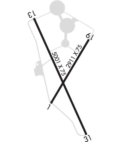
Airport Diagram might not be current. Facility Name: TILLAMOOK City Name: TILLAMOOK County: TILLAMOOK State abbrev: OR State Name: OREGON Ownership: PUBLICLY OWNED Use: OPEN TO THE PUBLIC Owner's Name: PORT OF TILLAMOOK BAY Address: 4000 BLIMP BLVD TILLAMOOK, OR 97141 Owner's Phone: (503) 842-7152 Manager's Name: JAMES PEAK Address: 4000 BLIMP BLVD TILLAMOOK, OR 97141 Phone: 503-842-2413; ALTERNATE NUMBER: 503-812-6192 FAA Region: NORTHWEST MOUNTAIN FAA Field Office: SEA
Runway Identifications Help
Runway Identification: 01/19 Length: 2911 ftWidth: 75 ftSurface: ASPHALT-GOOD CONDITIONEdge lights: Medium Intensity Treatment: NONE Runway: 01 Runway: 19 Mag heading: 10° Mag heading: 190° Rwy Slope: .24% Up Rwy Slope: -.24% Down Approach: Approach: Pattern: Left Traffic Pattern: Right Traffic Markings: BASIC Markings: BASIC Marking Condition: FAIR; MARKINGS FADING AND CHIPPING. Marking Condition: FAIR; MARKINGS FADING AND CHIPPING. Arresting Dev: Arresting Dev: Lat & Long: N4524.9 W12349.0 Lat. & Long.: N4525.3 W12348.6 Elev: 28.7 ft. MSL Elev: 35.6 ft. MSL TCH: 45 ft. AGL TCH: 40 ft. AGL Visual Glide Path: 4.00 degrees Visual Glide Path: 3.00 degrees Displaced Threshold: No Displaced Threshold: No Touchdown Zone: YES Touchdown Zone: YES Touchdown Elev.: 35.6 feet Touchdown Elev.: 35.6 feet Visual Glide Slope: 2-Light PAPI on LEFT side of Runway Visual Glide Slope: 2-Light PAPI on LEFT side of Runway RVR Equipment: RVR Equipment: RVV Equipment: NO RVV Equipment: NO Approach Lights: Approach Lights: REIL: NO REIL: NO Centerline Lights: NO Centerline Lights: NO Touchdown lights: NO Touchdown lights: NO Runway Category: Runway with a Visual Approach Runway Category: Runway with a Visual Approach Declared Distances: Declared Distances:
Runway Identification: 13/31 Length: 5001 ftWidth: 75 ftSurface: ASPHALT-GOOD CONDITIONEdge lights: Medium Intensity Treatment: NONE Runway: 13 Runway: 31 Mag heading: 135° Mag heading: 315° Rwy Slope: .38% Up Rwy Slope: -.38% Down Approach: Approach: Pattern: Left Traffic Pattern: Left Traffic Markings: NONPRECISION INSTRUMENT Markings: NONPRECISION INSTRUMENT Marking Condition: FAIR; NRS FADED. Marking Condition: FAIR Arresting Dev: Arresting Dev: Lat & Long: N4525.5 W12349.1 Lat. & Long.: N4524.7 W12348.7 Elev: 20.5 ft. MSL Elev: 39.4 ft. MSL TCH: 42 ft. AGL TCH: 40 ft. AGL Visual Glide Path: 3.00 degrees Visual Glide Path: 3.50 degrees Displaced Threshold: No Displaced Threshold: No Touchdown Zone: YES Touchdown Zone: YES Touchdown Elev.: 31.4 feet Touchdown Elev.: 39.4 feet Visual Glide Slope: 2-Light PAPI on LEFT side of Runway Visual Glide Slope: 2-Light PAPI on LEFT side of Runway RVR Equipment: RVR Equipment: RVV Equipment: NO RVV Equipment: NO Approach Lights: Approach Lights: REIL: YES REIL: NO Centerline Lights: NO Centerline Lights: NO Touchdown lights: NO Touchdown lights: NO Runway Category: Runway with a Non-precision Approach having visibility minimums greater than 3/4 mile Runway Category: Runway with a Visual Approach Declared Distances: Declared Distances: Obstructions: TREES Obstructions: TREE Marked: NOT Marked/Lighted Marked: NOT Marked/Lighted Clearance slope: 17:1 Clearance slope: 18:1 Obstruction height: 110 feet AGL Obstruction height: 123 feet AGL Dist. from runway: 2126 feet Dist. from runway: 2471 feet Centerline offset: 500 right of centerline Centerline offset: 350 feet right of centerline Comments: Comments: