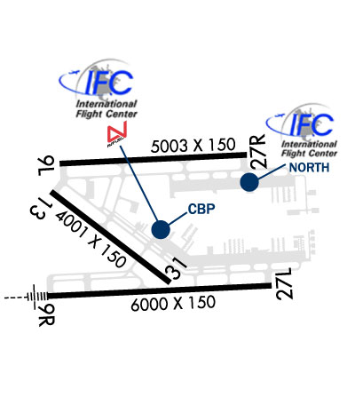
KTMB

MIAMI EXECUTIVE
MIAMI
FL
Time Zone: Eastern
Lat: N 2538.9
Long: W 08026.0
Elev: 10
Var: +06
Longest Runway: 6000
Clr Del: 133.0
Dept. ATIS: 124.0
Arr. ATIS: 124.0
Ground: 121.7
Tower: 118.9/134.6

FBO & Flight Services info for KTMB

FBOs: Update your Fuel Prices

  click here  
IFC is a full service FBO at KTMB providing industry-leading, boutique aviation experience. Everyone who passes through our doors is treated like a VIP & can be assured of 5 star service along with the utmost discretion, security & safety. Located on the SW side of KTMB, directly next to customs facility, we're well equipped to handle all aspects of intl travel. Can cater all your aviation needs.
Ph: 305-238-8122 Fax: 305-238-0464 Freq: 122.82WebsiteE-Mail
                     
Service
Jet
100LL
SAF
MoGas
Fuel Avail: PRIST +$0.10/gal. 24 HOURS ON CALL AFTER 9PM
Full6.507.90    Last Update: 03/26/2024 10:19

We offer discounts/Please Call
Self        
Misc. Info: always fuel discountAddress: 14592 SW 129TH ST   MIAMI FL 33186
IFC is a full service FBO at KTMB providing industry-leading, boutique aviation experience. Everyone who passes through our doors is treated like a VIP & can be assured of 5 star service along with the utmost discretion, security & safety.
Ph: 305-251-1982 Fax: 305-238-1966 Freq: 122.82WebsiteE-Mail
                     
Service
Jet
100LL
SAF
MoGas
Fuel Avail: PRIST +$0.10/gal. 7 days a week
Full6.507.90    Last Update: 03/26/2024 10:17

Self  6.95    
Misc. Info: We offer discounts on fuel. Feel free to contact us.Address: 14005 SW 127TH ST   MIAMI FL 33186

RELIANCE AVIATIONPh: 305-233-0310 Fax: 305-233-7504 Freq: 122.95
Service
Jet
100LL
SAF
MoGas
Fuel Avail: Discount w/volume. PRIST + $0.15/gal. 6:A - 9P, 24 Call out fee avail
Full6.558.05    Last Update: 03/26/2024 10:19  
Self        
 Address: 14532 SW 129TH ST   MIAMI, FL 33186
SIGNATUREPh: 305-871-3105 Fax: 305-871-3152 Freq: 130.45
Service
Jet
100LL
SAF
MoGas
Fuel Avail: Prist+ $0.10/gal
Full6.659.66    Last Update: 04/19/2024 07:53  
Self        
 Address: 14150 S.W. 129TH STREET   MIAMI, FL 33186
ADVANCED A/C CNTRPh: 305-259-8291 Fax: 305-259-8302 Freq: 123.3

ASOSPh: 305-235-1332
-
-
 
If you are an FBO, call 1-203-262-1700 to update your info or email: FltPlan.Advertising@garmin.com
Advertise your FBO on FltPlan.com

Runway & Approach Info for KTMB
Rwy
Length
Land Dist**
Approach*
  Rwy
Length
Land Dist**
Approach*
09L
5003x150  5003'          
 
  
27R
  5003x150  5003'          
 
09R
6000x150  6000'          
ILS
 108.70 - 093°  
  
27L
  6000x150  6000'          
 
13
4001x150  4001'          
 
  
31
  4001x150  4001'          
 
 * only ILS, LOC, LDA, and SDF approaches to a specific runway are shown
** For any Declared Landing Distance Available, please see A/FD or Approach plates
Runway Weight Capability (lbs.) Help
Runway IDSingle WheelDouble WheelDouble Tandem WheelDual Double Wheel
09L/27R87,000135,000195,000N/A
09R/27L87,000135,000195,000N/A
13/3187,000135,000195,000N/A
H1N/AN/AN/AN/A
These numbers are Advisory and are not limits.   The Airport Manager should have more accurate Weight Limits
Approach Charts
Approaches    
Current Weather/Notams
Customs Information Send updates to Support@FltPlan.com
Phone 305-969-1576
Fax 305-971-5741

Comments Sun-Sat 1100-1900 *1 hr advance notice *Maximum passengers per flight: 20 *Call within 24 hours of arrival*
Database effective 04/18/2024
Airport Diagram of KTMB
Airport Diagram might not be current.

Facility Name: MIAMI EXEC
City Name: MIAMI
County: DADE
State abbrev: FL
State Name: FLORIDA
   
Ownership: PUBLICLY OWNED
Use: OPEN TO THE PUBLIC
Owner's Name: MIAMI-DADE COUNTY; CTC PERSON: LIONEL BECKLES, 305-876-7038.
Address: MIAMI -DADE AVIATION DEPT., P.O. BOX 025504
 MIAMI, FL 33102-5504
Owner's Phone: 305-876-0464
  
Manager's Name: JONATHAN SPICER
Address: 12800 SW 145TH AVE
 MIAMI, FL 33186
Phone: 305-869-1702
   
FAA Region: SOUTHERN
FAA Field Office: ORL


Sunrise / Sunset times for MIAMI EXEC

DateSunriseSunset
04/18/24 Thursday6:5519:47
04/19/24 Friday6:5519:47
04/20/24 Saturday6:5419:48
04/21/24 Sunday6:5319:48
04/22/24 Monday6:5219:49
04/23/24 Tuesday6:5119:49
04/24/24 Wednesday6:5019:50
04/25/24 Thursday6:4919:50
04/26/24 Friday6:4919:51
04/27/24 Saturday6:4819:51
04/28/24 Sunday6:4719:52
04/29/24 Monday6:4619:52
04/30/24 Tuesday6:4519:53
05/01/24 Wednesday6:4519:53

Airport Facilities

Airport Attendance ScheduleCONTINUOUS
Airport Status OPERATIONAL (This Status can change at any time - please check NOTAMS)
Airport Lighting ScheduleWHEN ATCT CLSD ACTVT MALSR RWY 09R; HIRL RWY 09R/27L; MIRL RWY 13/31; TWY - CTAF.
Airport Storage AvailableTie Downs, Hanger
Extra Services AvailableAir Ambulance, Avionics, Charter, Flight Instruction, Aircraft Rental, Aircraft Sales, Annual Surveying
Wind IndicatorYES - (lighted)
Control TowerYES
CTAF Frequency118.900
Unicom Frequency
Rotating Beacon ColorWG
Segmented CircleY-L
Landing FeeNO

Airport Inspection Data

Airport InspectedSTATE - performed by STATE AERONAUTICAL PERSONNEL
Inspection Date05/03/2018

Airport Services

Type of Fuel AvailableGrade 100LL, JET A (freeze point -40C)
Airframe Repair ServiceMAJOR
Power Plant Repair ServiceMAJOR

Geographic Data

LatitudeN2538.9
LongitudeW08026.0 (ESTIMATED)
Arpt Elevation10ft (SURVEYED)
Magnetic Variation06W
13 miles SWof MIAMI
Traffic Pattern AltitudeHEL TFC PAT RWY 09R WI FIXED WING PAT AT OR BLW 500 FT AGL.
Sectional ChartMIAMI

Aircraft Data

Operations (Reported)YearlyAvg. Daily
General Aviation Transient 116394319
General Aviation Local 75866208
Air Taxi 17855
Commerical 00
Commuter 00
Military 660
Aircraft based on Field
General Aviation Singles 104
General Aviation Multi 17
Jet Aircraft 5
General Aviation Helicopters 6
Military Aircraft 0
Gliders 3
Ultralights 0

FAA Services

FSS on field NO
FSS tie-in MIAMI
FSS Phone 1-800-WX-BRIEF
Who issues Notams TMB
Notam D service at airport YES
ARTCC Name MIAMI

Federal Status

Airport Certification
Aircraft Rescue & Firefighting IndexNone
Airport of EntryNo
Custom Landing RightsYES; US CBP 0900-2400 - 305-969-7511.
Joint Civil/MilitaryNo
Military Landing rightsYES

Federal Agreements

NATIONAL PLAN OF INTEGRATED AIRPORT SYSTEMS (NPIAS)
GRANT AGREEMENTS UNDER FAAP/ADAP/AIP
ASSURANCES PURSUANT TO TITLE VI, CIVIL RIGHTS ACT OF 1964

Remarks

ARPT CLSD TO NON-ENG ACFT.
NOISE SENSITIVE ARPT; FLT TRNG LTD WKDAY 1200-0400Z ; WKEND & OBSERVED HOL 1400-0200Z.
FOR CD IF UNA TO CTC ON FSS FREQ, CTC MIAMI APCH AT 305-869-5432.
US CBP AND EAPIS AVBL. 1500-0100Z++-305-969-7511. OPS. MNT FREQ 118.9 DURING CTAF OPS.
RWY 9L-27R AND RWY 13-31 CLSD DLY 0400-1200Z++
US CBP EXTD HRS AVBL UPON REQ, EMAIL KTMB-ARRIVALS@CBP.DHS.GOV PRIOR TO 2300Z++.
BIRDS & AGRICULTURAL OPS BLW 200 FT AGL SR TO SS ON AND INVOF ARPT.
PTNS OF TWY A BTN SPOTS 1 & 2 & PTNS OF TWY D BTN SPOTS 14 & 17 & PTNS OF TWY C BTN SPOTS 13 &14 NOT VSB FM ATCT. SIMUL MOV OF ACFT WITH WINGSPANS IN EXCESS OF 95 FT ARE PRECLUDED FM USING PARL TWY C AND TWY D.
NOISE ABATEMENT PROC IN EFCT; NO TURNS BLW 1000 FT - 305-869-1700.
Airport Communications & Frequencies:
ATIS Frequencies:   Hours(local) of Operation: CONTINUOUS
124.0
TAMIAMI Tower Frequencies:   Hours(local) of operation: 0700-2300   
118.9
124.9 ;270-090
TAMIAMI Ground Frequencies:
121.7
Clearance Delivery Frequencies:
133.0
CTAF Frequency:
118.900
MIAMI Primary Approach Frequencies:  
125.5
354.1
MIAMI Primary Departure Frequencies:  
125.5
354.1
VFR Advisory Frequencies:
118.9
Runway Identifications
Runway Identification: 09L/27R
Length: 5003 ft
Width: 150 ft
Surface: ASPHALT-FAIR CONDITION
Edge lights: Medium Intensity

Treatment: GROOVED
Weight: PCN 32 /F/A/Y/T

 Runway: 09L   Runway: 27R
Mag heading: 93°Mag heading: 273°
Rwy Slope: .00%Rwy Slope: .00%
Approach: Approach:
Pattern: Left TrafficPattern: Right Traffic
Markings: NONPRECISION INSTRUMENTMarkings: NONPRECISION INSTRUMENT
Marking Condition: FAIRMarking Condition: FAIR
Arresting Dev: Arresting Dev:
Lat & Long: N2539.2  W08026.4Lat. & Long.: N2539.2  W08025.5
Elev: 7.8 ft. MSLElev: 7.8 ft. MSL
TCH: 53 ft. AGLTCH: 40 ft. AGL
Visual Glide Path: 3.00 degreesVisual Glide Path: 3.00 degrees
Displaced Threshold: NoDisplaced Threshold: No
Touchdown Zone: YESTouchdown Zone: YES
Touchdown Elev.: 8.2 feetTouchdown Elev.: 8.1 feet
Visual Glide Slope: 4-Light PAPI on LEFT side of RunwayVisual Glide Slope: 2-Light PAPI on LEFT side of Runway; PAPI UNUSBL BYD 9 DEGS LEFT & 7 DEGS RIGHT OF CNTRLN.
RVR Equipment: RVR Equipment:
RVV Equipment: NORVV Equipment: NO
Approach Lights: Approach Lights:
REIL: NOREIL: NO
Centerline Lights: NOCenterline Lights: NO
Touchdown lights: NOTouchdown lights: NO
Runway Category: DRunway Category: D
Declared Distances: Declared Distances:
Obstructions: Obstructions: TOWER
Marked: Marked: MARKED and LIGHTED
Clearance slope: 50:1; APCH SLOPE 34:1 FM DSPLCD THR.Clearance slope: 50:1
Obstruction height: Obstruction height: 85 feet AGL
Dist. from runway: Dist. from runway: 4453 feet
Centerline offset: Centerline offset: 100 feet right of centerline
Comments: Comments:
Runway Identification: 09R/27L
Length: 6000 ft
Width: 150 ft
Surface: ASPHALT-FAIR CONDITION
Edge lights: High Intensity

Treatment: GROOVED
Weight: PCN 32 /F/A/Y/T

 Runway: 09R   Runway: 27L
Mag heading: 93°Mag heading: 273°
Rwy Slope: -.04% DownRwy Slope: .04% Up
Approach: ILSApproach:
Pattern: Right TrafficPattern: Left Traffic
Markings: PRECISION INSTRUMENTMarkings: PRECISION INSTRUMENT
Marking Condition: GOODMarking Condition: GOOD
Arresting Dev: Arresting Dev:
Lat & Long: N2538.6  W08026.5Lat. & Long.: N2538.6  W08025.4
Elev: 10.0 ft. MSLElev: 7.9 ft. MSL
TCH: 55 ft. AGLTCH: 53 ft. AGL
Visual Glide Path: 3.00 degreesVisual Glide Path: 3.00 degrees
Displaced Threshold: NoDisplaced Threshold: No
Touchdown Zone: YESTouchdown Zone: YES
Touchdown Elev.: 10.0 feetTouchdown Elev.: 8.1 feet
Visual Glide Slope: 4-Light PAPI on RIGHT side of RunwayVisual Glide Slope: 4-Light PAPI on LEFT side of Runway
RVR Equipment: RVR Equipment:
RVV Equipment: NORVV Equipment: NO
Approach Lights: MALSR - 1,400 foot medium intensity approach lighting system with runway alignment indicator lightsApproach Lights:
REIL: NOREIL: NO
Centerline Lights: NOCenterline Lights: NO
Touchdown lights: NOTouchdown lights: NO
Runway Category: Precision Instrument RunwayRunway Category: D
Declared Distances: Declared Distances:
Runway Identification: 13/31
Length: 4001 ft
Width: 150 ft
Surface: ASPHALT-FAIR CONDITION
Edge lights: Medium Intensity

Treatment: GROOVED
Weight: PCN 32 /F/A/Y/T

 Runway: 13   Runway: 31
Mag heading: 133°Mag heading: 313°
Rwy Slope: .00% DownRwy Slope: .00% Up
Approach: Approach:
Pattern: Left TrafficPattern: Left Traffic
Markings: BASICMarkings: BASIC
Marking Condition: FAIRMarking Condition: FAIR
Arresting Dev: Arresting Dev:
Lat & Long: N2539.0  W08026.4Lat. & Long.: N2538.6  W08025.9
Elev: 8.0 ft. MSLElev: 7.8 ft. MSL
TCH: 40 ft. AGLTCH:
Visual Glide Path: 3.00 degreesVisual Glide Path:
Displaced Threshold: NoDisplaced Threshold: No
Touchdown Zone: YESTouchdown Zone: YES
Touchdown Elev.: 8.1 feetTouchdown Elev.: 8.1 feet
Visual Glide Slope: 4-Light PAPI on LEFT side of RunwayVisual Glide Slope:
RVR Equipment: RVR Equipment:
RVV Equipment: NORVV Equipment: NO
Approach Lights: Approach Lights:
REIL: YESREIL: NO
Centerline Lights: NOCenterline Lights: NO
Touchdown lights: NOTouchdown lights: NO
Runway Category: Runway with a Visual ApproachRunway Category: Runway with a Visual Approach
Declared Distances: Declared Distances:
Obstructions: Obstructions: POLE
Marked: Marked: NOT Marked/Lighted
Clearance slope: 50:1Clearance slope: 36:1
Obstruction height: Obstruction height: 29 feet AGL
Dist. from runway: Dist. from runway: 1215 feet
Centerline offset: Centerline offset: 250 feet left of centerline
Comments: Comments:
Runway Identification: H1 HELIPAD
Length: 75 ft
Width: 75 ft
Surface: CONCRETE-FAIR CONDITION
Edge lights:

Treatment: NONE

C:171/P: