Click here for more info on on SMS!

KTIX

SPACE COAST RGNL
TITUSVILLE
FL
Time Zone: Eastern
Lat: N 2830.9
Long: W 08048.0
Elev: 34
Var: +05
Longest Runway: 7319
Dept. ATIS: 120.62
Arr. ATIS: 120.62
Ground: 121.85
Tower: 118.9

FBO & Flight Services info for KTIX

FBOs: Update your Fuel Prices
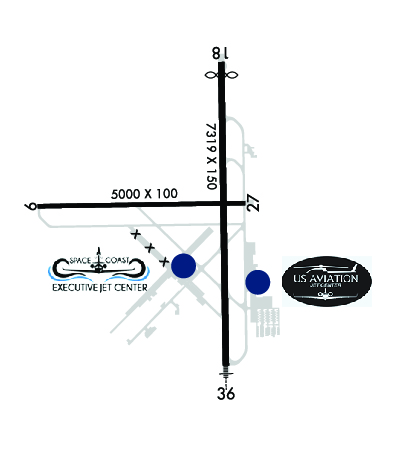
All our guests get the VIP treatment including pets. We're a family run, full service FBO with the only lit ramp on the field, measuring 128k + sq ft. We offer a quick turn with our two Jet-A trucks, GPU, Oxygen & Lav Service. 24 hr self-serve 100LL avail. Avis & Enterprise rental cars onsite. Complimentary snacks & coffee. Conference room avail. Gladly accept AirCard & most major contract fuel.
Ph: 321-267-8355 Fax: 321-267-0129 Freq: 122.95WebsiteE-Mail
                     
Service
Jet
100LL
SAF
MoGas
Fuel Avail: After hours, by appointment, call 321-267-8355
Full5.506.35    Last Update: 03/26/2024 10:05
PRICES GUARANTEED by FBO.
Self  5.25    
Misc. Info: GPU,Lav,Oxygen, AVIS/Enterprise ON-Site. Call for bulk discounts - Open 7 days 0800-1800Address: 7003 CHALLENGER AVENUE   TITUSVILLE, FL 32780

  click here  
The US Aviation Jet Center team is dedicated to providing each guest with a warm, sunny welcome to Florida's Space Coast. We strive to consistently provide guests with exceptional customer service, ucompromised safety, competitive fuel prices and pristine facilities.
Ph: 321-567-6000
-
Freq: 122.95WebsiteE-Mail
                          
Service
Jet
100LL
SAF
MoGas
Fuel Avail: M-F 0700-1900, S-S 0800-1800 *After hours call - (321)427-7727
Full5.326.31    Last Update: 04/20/2024 14:31

Self        
Misc. Info: Please call for fuel discounts, overnight fees, and reservation assistance.Address: 355 GOLDEN KNIGHTS BLVD,   TITUSVILLE, FL 32780

If you are an FBO, call 1-203-262-1700 to update your info or email: FltPlan.Advertising@garmin.com
Advertise your FBO on FltPlan.com

Runway & Approach Info for KTIX
Rwy
Length
Land Dist**
Approach*
  Rwy
Length
Land Dist**
Approach*
09
5000x100  5000'          
 
  
27
  5000x100  5000'          
 
18
7319x150  6997'          
 
  
36
  7319x150  7319'          
ILS
 108.70 - 004°  
 * only ILS, LOC, LDA, and SDF approaches to a specific runway are shown
** For any Declared Landing Distance Available, please see A/FD or Approach plates
Runway Weight Capability (lbs.) Help
Runway IDSingle WheelDouble WheelDouble Tandem WheelDual Double Wheel
09/2750,00080,000N/AN/A
18/3680,000110,000190,000N/A
These numbers are Advisory and are not limits.   The Airport Manager should have more accurate Weight Limits
Approach Charts
Approaches    
Current Weather/Notams
Customs Information Send updates to Support@FltPlan.com
Customs Not Available
Database effective 05/16/2024
Airport Diagram of KTIX
Airport Diagram might not be current.

Facility Name: SPACE COAST RGNL
City Name: TITUSVILLE
County: BREVARD
State abbrev: FL
State Name: FLORIDA
   
Ownership: PUBLICLY OWNED
Use: OPEN TO THE PUBLIC
Owner's Name: TITUSVILLE COCOA ARPT AUTH
Address: 51 BRISTOW WAY
 TITUSVILLE, FL 32780
Owner's Phone: 321-267-8780
  
Manager's Name: KEVIN DAUGHERTY, AAE
Address: 355 GOLDEN KNIGHTS BLVD
 TITUSVILLE, FL 32780
Phone: 321-267-8780
   
FAA Region: SOUTHERN
FAA Field Office: ORL


Sunrise / Sunset times for SPACE COAST RGNL

DateSunriseSunset
04/24/24 Wednesday6:4819:55
04/25/24 Thursday6:4719:55
04/26/24 Friday6:4619:56
04/27/24 Saturday6:4519:56
04/28/24 Sunday6:4419:57
04/29/24 Monday6:4419:58
04/30/24 Tuesday6:4319:58
05/01/24 Wednesday6:4219:59
05/02/24 Thursday6:4119:59
05/03/24 Friday6:4020:00
05/04/24 Saturday6:4020:01
05/05/24 Sunday6:3920:01
05/06/24 Monday6:3820:02
05/07/24 Tuesday6:3720:02

Airport Facilities

Airport Attendance Schedule7 Days A Week 0700-2100
Airport Status OPERATIONAL (This Status can change at any time - please check NOTAMS)
Airport Lighting ScheduleWHEN ATCT CLSD ACTVT MALSR RWY 36; REIL RWYS 9, 18, & 27; PAPI RWYS 09, 27, 18, & 36; MIRL RWY 09/27; HIRL RWY 18/36 - CTAF.
Airport Storage AvailableTie Downs, Hanger
Extra Services AvailableAvionics, Charter, Flight Instruction, Aircraft Rental, Aircraft Sales
Wind IndicatorYES - (lighted)
Control TowerYES
CTAF Frequency118.900
Unicom Frequency122.950
Rotating Beacon ColorWG
Segmented CircleNO
Landing FeeNO

Airport Inspection Data

Airport InspectedFEDERAL - performed by FAA AIRPORTS FIELD PERSONNEL
Inspection Date01/24/2024

Airport Services

Type of Fuel AvailableGrade 100LL, JET A (freeze point -40C); -10FOR FUEL AFT HRS CALL 321-267-8355 OR 321-603-6380.
Airframe Repair ServiceMAJOR
Power Plant Repair ServiceMAJOR

Geographic Data

LatitudeN2830.9
LongitudeW08048.0 (ESTIMATED)
Arpt Elevation33ft (SURVEYED)
Magnetic Variation05W
5 miles Sof TITUSVILLE
Traffic Pattern Altitude
Sectional ChartJACKSONVILLE

Aircraft Data

Operations (Reported)YearlyAvg. Daily
General Aviation Transient 37845104
General Aviation Local 63493174
Air Taxi 4481
Commerical 00
Commuter 00
Military 730
Aircraft based on Field
General Aviation Singles 82
General Aviation Multi 11
Jet Aircraft 1
General Aviation Helicopters 16
Military Aircraft 0
Gliders 0
Ultralights 0

FAA Services

FSS on field NO
FSS tie-in SAINT PETERSBURG
FSS Phone 1-800-WX-BRIEF
Who issues Notams TIX
Notam D service at airport YES
ARTCC Name MIAMI

Federal Status

Airport CertificationCLSD TO ACR OPNS WITH MORE THAN 30 PAX SEATS EXC PPR CALL AMGR 321-267-8780. INDEX A ARFF EQUIPMENT AVAILABLE MONDAY-FRIDAY 0700-1600 L OR UPON REQ. CONTACT ARPT FIRE CHIEF TO COORD 321-289-5393.
Aircraft Rescue & Firefighting IndexAIRPORT HAS A CERTIFICATE UNDER CFR PART 139
Airport of EntryNo
Custom Landing RightsNo
Joint Civil/MilitaryNo
Military Landing rightsYES

Federal Agreements

NATIONAL PLAN OF INTEGRATED AIRPORT SYSTEMS (NPIAS)
GRANT AGREEMENTS UNDER FAAP/ADAP/AIP
SURPLUS PROPERTY AGREEMENT UNDER REGULATION 16-WAA
ASSURANCES PURSUANT TO TITLE VI, CIVIL RIGHTS ACT OF 1964
AGREEMENT UNDER DLAND OR DCLA HAS EXPIRED.

Remarks

IN MINIMUM VIS CONDS BRIGHT LGTS IN PARKING LOT 1/4 MILE E OF RY 18 MAY BE MISTAKEN FOR RY LGTS.
ATCT UNABLE AIR TRAFFIC SVCS ON THESE AREAS OF NON-VISIBILITY: SOUTHWEST PORTIONS OF TAXILANES 'D' AND 'E'.
FOR CD OR TO CNL IFR IF UNA TO CTC ON FSS FREQ, CTC ORLANDO APCH AT 407-852-7500.
RWY 18/3 6 RWY 18/36 CLSD TO UNSKED AIR CARRIER OPS MORE THAN 30 PAX SEATS.
Airport Communications & Frequencies:
ATIS Frequencies:   Hours(local) of Operation: 24 HRS.
120.625
SPACE COAST Tower Frequencies:   Hours(local) of operation: 0700-2100   
118.9
SPACE COAST Ground Frequencies:
121.85
Emergency Frequencies:
121.5
243.0
CTAF Frequency:
118.900
Unicom Frequency:
122.950
ORLANDO Primary Approach Frequencies:  
134.95
281.425
ORLANDO Primary Departure Frequencies:  
134.95
281.425
Runway Identifications
Runway Identification: 09/27
Length: 5000 ft
Width: 100 ft
Surface: ASPHALT
Edge lights: Medium Intensity

Treatment: NONE
Weight: PCN 41 /F/B/W/T

 Runway: 09   Runway: 27
Mag heading: 94°Mag heading: 274°
Rwy Slope: -.02% DownRwy Slope: .02% Up
Approach: Approach:
Pattern: Left TrafficPattern: Left Traffic
Markings: NONPRECISION INSTRUMENTMarkings: NONPRECISION INSTRUMENT
Marking Condition: FAIRMarking Condition: FAIR
Arresting Dev: Arresting Dev:
Lat & Long: N2830.9  W08048.6Lat. & Long.: N2830.9  W08047.7
Elev: 32.3 ft. MSLElev: 31.2 ft. MSL
TCH: 42 ft. AGLTCH: 45 ft. AGL
Visual Glide Path: 3.00 degreesVisual Glide Path: 3.00 degrees
Displaced Threshold: NoDisplaced Threshold: No
Touchdown Zone: YESTouchdown Zone: YES
Touchdown Elev.: 32.4 feetTouchdown Elev.: 31.9 feet
Visual Glide Slope: 4-Light PAPI on LEFT side of RunwayVisual Glide Slope: 4-Light PAPI on LEFT side of Runway
RVR Equipment: RVR Equipment:
RVV Equipment: NORVV Equipment: NO
Approach Lights: Approach Lights:
REIL: YESREIL: YES
Centerline Lights: NOCenterline Lights: NO
Touchdown lights: NOTouchdown lights: NO
Runway Category: Runway with a Non-precision Approach having visibility minimums greater than 3/4 mileRunway Category: Runway with a Visual Approach
Declared Distances: TORA:5000' TODA:5000' ASDA:5000' LDA:5000'Declared Distances: TORA:5000' TODA:5000' ASDA:5000' LDA:5000'
Obstructions: TREESObstructions: TREES
Marked: NOT Marked/LightedMarked: NOT Marked/Lighted
Clearance slope: 34:1Clearance slope: 20:1
Obstruction height: 29 feet AGLObstruction height: 53 feet AGL
Dist. from runway: 1215 feetDist. from runway: 1260 feet
Centerline offset: 240 left of centerlineCenterline offset: 265 feet left of centerline
Comments: Comments:
Runway Identification: 18/36
Length: 7319 ft
Width: 150 ft
Surface: ASPHALT-FAIR CONDITION
Edge lights: High Intensity

Treatment: GROOVED
Weight: PCN 41 /F/A/W/T

 Runway: 18   Runway: 36
Mag heading: 184°Mag heading:
Rwy Slope: .05% UpRwy Slope: -.05% Down
Approach: Approach: ILS
Pattern: Left TrafficPattern: Left Traffic
Markings: NONPRECISION INSTRUMENTMarkings: PRECISION INSTRUMENT
Marking Condition: FAIRMarking Condition: FAIR
Arresting Dev: Arresting Dev:
Lat & Long: N2831.5  W08047.8Lat. & Long.: N2830.3  W08047.8
Elev: 29.6 ft. MSLElev: 33.6 ft. MSL
TCH: 44 ft. AGLTCH: 56 ft. AGL
Visual Glide Path: 3.00 degreesVisual Glide Path: 3.00 degrees
Displaced Threshold: 322 feetDisplaced Threshold: No
Touchdown Zone: YESTouchdown Zone: YES
Touchdown Elev.: 31.7 feetTouchdown Elev.: 33.8 feet
Visual Glide Slope: 4-Light PAPI on LEFT side of RunwayVisual Glide Slope: 4-Light PAPI on LEFT side of Runway
RVR Equipment: RVR Equipment:
RVV Equipment: NORVV Equipment: NO
Approach Lights: Approach Lights: MALSR - 1,400 foot medium intensity approach lighting system with runway alignment indicator lights
REIL: YESREIL: NO
Centerline Lights: NOCenterline Lights: NO
Touchdown lights: NOTouchdown lights: NO
Runway Category: Runway with a Non-precision Approach having visibility minimums greater than 3/4 mileRunway Category: Precision Instrument Runway
Declared Distances: TORA:7319' TODA:7319' ASDA:7249' LDA:6930'Declared Distances: TORA:7319' TODA:7319' ASDA:7244' LDA:7244'
Obstructions: TREESObstructions: TREES
Marked: NOT Marked/LightedMarked: NOT Marked/Lighted
Clearance slope: 24:1Clearance slope: 39:1
Obstruction height: 52 feet AGLObstruction height: 24 feet AGL
Dist. from runway: 1465 feetDist. from runway: 1155 feet
Centerline offset: 45 left of centerlineCenterline offset: 365 feet left of centerline
Comments: TREES 425 FT LEFT & RIGHT OF CNTRLN FIRST 1500 FT OF RWY 18.Comments:
C:19/P: