
| |||||||||||||||||||||||||||||||||||||||||||||||||||||||||||||||||||||
| |||||||||||||||||||||||||||||||||||||||||||||||||||||||||||||||||||||
| |||||||||||||||||||||||||||||||||||||||||||||||||||||||||||||||||||||
| |||||||||||||||||||||||||||||||||||||||||||||||||||||||||||||||||||||
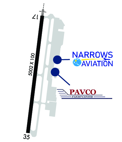
| Rwy | Rwy | |||||||
| 5002x100 | 5002' | 109.10 - 167° | 5002x100 | 5002' | ||||
| Runway ID | Single Wheel | Double Wheel | Double Tandem Wheel | Dual Double Wheel |
| 17/35 | 50,000 | 80,000 | 80,000 | 150,000 |
| These numbers are Advisory and are not limits. The Airport Manager should have more accurate Weight Limits | ||||
 Airport Diagram might not be current. | |
| Facility Name: | TACOMA NARROWS |
| City Name: | TACOMA |
| County: | PIERCE |
| State abbrev: | WA |
| State Name: | WASHINGTON |
| Ownership: | PUBLICLY OWNED |
| Use: | OPEN TO THE PUBLIC |
| Owner's Name: | PIERCE COUNTY PUB WORKS & UTILITIES |
| Address: | 9850 - 64TH ST. W. |
| UNIVERSITY PLACE, WA 98467-7322 | |
| Owner's Phone: | 253-798-2421 |
| Manager's Name: | ROD PROPST |
| Address: | 1202 - 26TH AVE. N.W. |
| GIG HARBOR, WA 98335-7322 | |
| Phone: | 253-798-8550 |
| FAA Region: | NORTHWEST MOUNTAIN |
| FAA Field Office: | SEA |
| Date | Sunrise | Sunset |
|---|---|---|
| 04/15/24 Monday | 6:20 | 20:01 |
| 04/16/24 Tuesday | 6:19 | 20:02 |
| 04/17/24 Wednesday | 6:17 | 20:03 |
| 04/18/24 Thursday | 6:15 | 20:05 |
| 04/19/24 Friday | 6:13 | 20:06 |
| 04/20/24 Saturday | 6:11 | 20:08 |
| 04/21/24 Sunday | 6:10 | 20:09 |
| 04/22/24 Monday | 6:08 | 20:10 |
| 04/23/24 Tuesday | 6:06 | 20:12 |
| 04/24/24 Wednesday | 6:04 | 20:13 |
| 04/25/24 Thursday | 6:03 | 20:15 |
| 04/26/24 Friday | 6:01 | 20:16 |
| 04/27/24 Saturday | 5:59 | 20:17 |
| 04/28/24 Sunday | 5:57 | 20:19 |
| Airport Attendance Schedule | 7 Days A Week 0700-1600 |
| Airport Status | OPERATIONAL (This Status can change at any time - please check NOTAMS) |
| Airport Lighting Schedule | WHEN ATCT CLSD, ACTVT MALSR RWY 17; REIL RWY 35; PAPI RWY 17 & 35; MIRL 17/35 - CTAF. |
| Airport Storage Available | Tie Downs, Hanger |
| Extra Services Available | Avionics, Charter, Flight Instruction, Aircraft Rental, Aircraft Sales |
| Wind Indicator | YES - (lighted) |
| Control Tower | YES |
| CTAF Frequency | 118.500 |
| Unicom Frequency | 122.950 |
| Rotating Beacon Color | WG |
| Segmented Circle | YES |
| Landing Fee | NO |
| Airport Inspected | STATE - performed by STATE AERONAUTICAL PERSONNEL |
| Inspection Date | 09/20/2023 |
| Type of Fuel Available | Grade 100LL, JET A (freeze point -40C) |
| Airframe Repair Service | MAJOR |
| Power Plant Repair Service | MAJOR |
| Latitude | N4716.1 |
| Longitude | W12234.7 (ESTIMATED) |
| Arpt Elevation | 294ft (SURVEYED) |
| Magnetic Variation | 20E |
| 4 miles W | of TACOMA |
| Traffic Pattern Altitude | 1000 |
| Sectional Chart | SEATTLE |
| Operations (Reported) | Yearly | Avg. Daily |
|---|---|---|
| General Aviation Transient | 30274 | 83 |
| General Aviation Local | 21531 | 59 |
| Air Taxi | 805 | 2 |
| Commerical | 0 | 0 |
| Commuter | 0 | 0 |
| Military | 666 | 2 |
| Aircraft based on Field | |
|---|---|
| General Aviation Singles | 86 |
| General Aviation Multi | 9 |
| Jet Aircraft | 5 |
| General Aviation Helicopters | 3 |
| Military Aircraft | 0 |
| Gliders | 0 |
| Ultralights | 0 |
| FSS on field | NO |
| FSS tie-in | SEATTLE |
| FSS Phone | 1-800-WX-BRIEF |
| Who issues Notams | TIW |
| Notam D service at airport | YES |
| ARTCC Name | SEATTLE |
| Airport Certification | |
| Aircraft Rescue & Firefighting Index | None |
| Airport of Entry | No |
| Custom Landing Rights | YES; FOR CUSTOMS CALL 253-593-6338 EXT #2. |
| Joint Civil/Military | No |
| Military Landing rights | YES |
| NATIONAL PLAN OF INTEGRATED AIRPORT SYSTEMS (NPIAS) |
| GRANT AGREEMENTS UNDER FAAP/ADAP/AIP |
| ASSURANCES PURSUANT TO TITLE VI, CIVIL RIGHTS ACT OF 1964 |
| NOISE SENSITIVE ARPT; FOR NOISE ABATEMENT & TFC PROCEDURES CALL AIRPORT OFFICE 253-798-8550. |
| DEER ON & INVOF ARPT. |
| (E94) LAWRS OPERS DURING TWR OPNS ONLY. |
| EMERG FREQ 121.5 NOT MNT AT TWR. |
| FOR CD WHEN ATCT IS CLSD CTC SEATTLE APCH AT 206-214-4723. |
Airport Communications & Frequencies:
| |||||||||||||||||||||||||
| Runway: 17 | Runway: 35 | ||
| Mag heading: | 167° | Mag heading: | 347° |
| Rwy Slope: | .06% Up | Rwy Slope: | -.06% Down |
| Approach: | ILS | Approach: | |
| Pattern: | Left Traffic | Pattern: | Right Traffic |
| Markings: | PRECISION INSTRUMENT | Markings: | NONPRECISION INSTRUMENT |
| Marking Condition: | GOOD | Marking Condition: | GOOD |
| Arresting Dev: | Arresting Dev: | ||
| Lat & Long: | N4716.5 W12234.6 | Lat. & Long.: | N4715.7 W12234.8 |
| Elev: | 291.8 ft. MSL | Elev: | 294.7 ft. MSL |
| TCH: | 52 ft. AGL | TCH: | 45 ft. AGL |
| Visual Glide Path: | 3.00 degrees | Visual Glide Path: | 3.00 degrees |
| Displaced Threshold: | No | Displaced Threshold: | No |
| Touchdown Zone: | YES | Touchdown Zone: | YES |
| Touchdown Elev.: | 294.7 feet | Touchdown Elev.: | 294.8 feet |
| Visual Glide Slope: | 4-Light PAPI on RIGHT side of Runway | Visual Glide Slope: | 4-Light PAPI on LEFT side of Runway; PAPI UNUSBL BYD 5.0 DEGREES LEFT OF CNTRLN. |
| RVR Equipment: | RVR Equipment: | ||
| RVV Equipment: | NO | RVV Equipment: | NO |
| Approach Lights: | MALSR - 1,400 foot medium intensity approach lighting system with runway alignment indicator lights | Approach Lights: | |
| REIL: | NO | REIL: | YES |
| Centerline Lights: | NO | Centerline Lights: | NO |
| Touchdown lights: | NO | Touchdown lights: | NO |
| Runway Category: | Precision Instrument Runway | Runway Category: | Runway with a Non-precision Approach having visibility minimums greater than 3/4 mile |
| Declared Distances: | Declared Distances: |


