Current Weather/Notams (Metars, TAFs, Notams, NWS Forecast, PIREPS, and nearby weather)
Customs Information Send updates to Support@FltPlan.com
Customs Not Available
Database effective 05/16/2024
Airport Diagram might not be current.
|
| Facility Name: | YORK |
| City Name: | YORK |
| County: | YORK |
| State abbrev: | PA |
| State Name: | PENNSYLVANIA |
| | |
| Ownership: | PRIVATELY OWNED |
| Use: | OPEN TO THE PUBLIC |
| Owner's Name: | YORK BLDG PRODUCTS INC |
| Address: | PO BOX 2587 |
| | YORK, PA 17405 |
| Owner's Phone: | 717-792-5566 |
| | |
| Manager's Name: | MARK TOMLINSON |
| Address: | 6054 LINCOLN HIGHWAY WEST |
| | THOMASVILLE, PA 17364 |
| Phone: | 717-792-5566 |
| | |
| FAA Region: | EASTERN |
| FAA Field Office: | HAR |
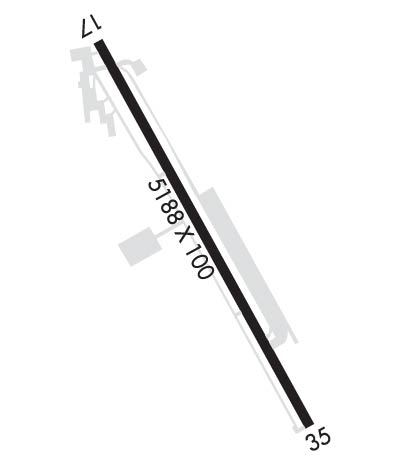
Runway Identifications
Runway Identification: 17/35Length: 5188 ft
Width: 100 ft
Surface: ASPHALT-GOOD CONDITION
Edge lights: Medium IntensityTreatment: GROOVED
| | Runway: 17 | | Runway: 35 |
| Mag heading: | 166° | Mag heading: | 346° |
| Rwy Slope: | .36% Up | Rwy Slope: | -.36% Down |
| Approach: | | Approach: | |
| Pattern: | Left Traffic | Pattern: | Left Traffic |
| Markings: | NONPRECISION INSTRUMENT | Markings: | NONPRECISION INSTRUMENT |
| Marking Condition: | GOOD | Marking Condition: | GOOD |
| Arresting Dev: | | Arresting Dev: | |
| Lat & Long: | N3955.4 W07652.6 | Lat. & Long.: | N3954.6 W07652.2 |
| Elev: | 475.8 ft. MSL | Elev: | 494.7 ft. MSL |
| TCH: | 20 ft. AGL | TCH: | 28 ft. AGL |
| Visual Glide Path: | 4.50 degrees | Visual Glide Path: | 3.67 degrees |
| Displaced Threshold: | 794 feet | Displaced Threshold: | 739 feet |
| Touchdown Zone: | YES | Touchdown Zone: | YES |
| Touchdown Elev.: | 477.5 feet | Touchdown Elev.: | 484.7 feet |
| Visual Glide Slope: | 4-Light PAPI on LEFT side of Runway | Visual Glide Slope: | 4-Light PAPI on LEFT side of Runway |
| RVR Equipment: | | RVR Equipment: | |
| RVV Equipment: | NO | RVV Equipment: | NO |
| Approach Lights: | | Approach Lights: | |
| REIL: | YES | REIL: | YES |
| Centerline Lights: | NO | Centerline Lights: | NO |
| Touchdown lights: | NO | Touchdown lights: | NO |
| Runway Category: | Runway with a Non-precision Approach having visibility minimums greater than 3/4 mile | Runway Category: | Runway with a Non-precision Approach having visibility minimums greater than 3/4 mile |
| Declared Distances: | | Declared Distances: | |
| Obstructions: | POLE | Obstructions: | TREES |
| Marked: | LIGHTED | Marked: | LIGHTED |
| Clearance slope: | 1:1; 20:1 TO DTHR. | Clearance slope: | 4:1; RWY 35 APCH SLP 23:1 TO DTHR. |
| Obstruction height: | 40 feet AGL | Obstruction height: | 43 feet AGL |
| Dist. from runway: | 226 feet | Dist. from runway: | 404 feet |
| Centerline offset: | 183 right of centerline | Centerline offset: | 223 feet left of centerline |
| Comments: | RWY 17 HAS +15 FT ROAD 10-200 FT FROM RWY END 250 FT LEFT & RIGHT; +15 BLAST FENCE 50-85 FT FROM RWY END MARKED AND LIGHTED. | Comments: | |

