Current Weather/Notams (Metars, TAFs, Notams, NWS Forecast, PIREPS, and nearby weather)
Customs Information Send updates to Support@FltPlan.com
Phone 419-259-6424
Fax 419-259-3703
Comments Mon-Sat 0830-1630 * 2hr prior notice * 15 max. passengers * Call prior to 1630 on preceding weekday.
Database effective 04/18/2024
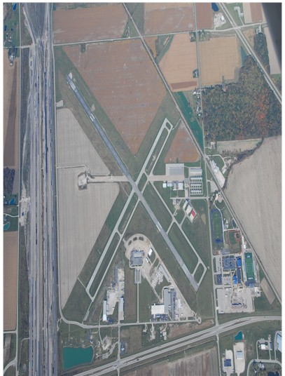
Airport Diagram might not be current.
|
| Facility Name: | TOLEDO EXEC |
| City Name: | TOLEDO |
| County: | WOOD |
| State abbrev: | OH |
| State Name: | OHIO |
| | |
| Ownership: | PUBLICLY OWNED |
| Use: | OPEN TO THE PUBLIC |
| Owner's Name: | TOLEDO LUCAS COUNTY PORT AUTHORITY |
| Address: | 1 MARITIME PLZ |
| | TOLEDO, OH 43604-1893 |
| Owner's Phone: | 419-243-8251 |
| | |
| Manager's Name: | STEVE ARNOLD |
| Address: | 11013 AIRPORT HWY STE 11; ARPT PHYS ADS: 28331 LEMOYNE RD, MILLBURY, OH 43447. |
| | SWANTON, OH 43558-9403 |
| Phone: | 419-838-6921 |
| | |
| FAA Region: | GREAT LAKES |
| FAA Field Office: | DET |
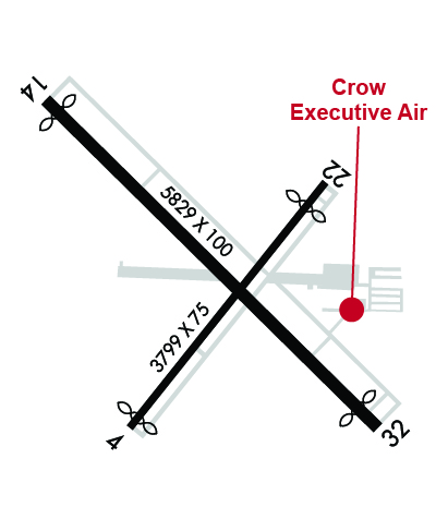
Runway Identifications
Runway Identification: 04/22Length: 3799 ft
Width: 75 ft
Surface: ASPHALT-FAIR CONDITION
Edge lights: Medium IntensityTreatment: NONE
| | Runway: 04 | | Runway: 22 |
| Mag heading: | 46° | Mag heading: | 226° |
| Rwy Slope: | -.06% Down | Rwy Slope: | .06% Up |
| Approach: | | Approach: | |
| Pattern: | Left Traffic | Pattern: | Left Traffic |
| Markings: | NONPRECISION INSTRUMENT | Markings: | NONPRECISION INSTRUMENT |
| Marking Condition: | FAIR | Marking Condition: | FAIR |
| Arresting Dev: | | Arresting Dev: | |
| Lat & Long: | N4133.6 W08329.2 | Lat. & Long.: | N4134.1 W08328.7 |
| Elev: | 622.7 ft. MSL | Elev: | 620.5 ft. MSL |
| TCH: | 35 ft. AGL | TCH: | 25 ft. AGL |
| Visual Glide Path: | 3.50 degrees | Visual Glide Path: | 3.00 degrees |
| Displaced Threshold: | 100 feet | Displaced Threshold: | 380 feet |
| Touchdown Zone: | YES | Touchdown Zone: | YES |
| Touchdown Elev.: | 622.7 feet | Touchdown Elev.: | 622.5 feet |
| Visual Glide Slope: | 4-Light PAPI on LEFT side of Runway | Visual Glide Slope: | 4-Light PAPI on LEFT side of Runway |
| RVR Equipment: | | RVR Equipment: | |
| RVV Equipment: | NO | RVV Equipment: | NO |
| Approach Lights: | | Approach Lights: | |
| REIL: | YES | REIL: | YES |
| Centerline Lights: | NO | Centerline Lights: | NO |
| Touchdown lights: | NO | Touchdown lights: | NO |
| Runway Category: | Runway with a Non-precision Approach | Runway Category: | Runway with a Visual Approach |
| Declared Distances: | | Declared Distances: | |
| Obstructions: | ROAD; ALSO 29 FT RR, 361 FT DIST, 262 FT L, 5:1. | Obstructions: | TREE |
| Marked: | NOT Marked/Lighted | Marked: | NOT Marked/Lighted |
| Clearance slope: | 14:1; APCH RATIO 34:1 TO DTHR. | Clearance slope: | 3:1; APCH RATIO 25:1 TO DTHR OVR 29 FT RR, 737 FT DIST, 308 FT L. |
| Obstruction height: | 15 feet AGL | Obstruction height: | 37 feet AGL |
| Dist. from runway: | 412 feet | Dist. from runway: | 333 feet |
| Centerline offset: | 280 right of centerline | Centerline offset: | 250 feet left of centerline |
| Comments: | | Comments: | |
Runway Identification: 14/32Length: 5829 ft
Width: 100 ft
Surface: ASPHALT-FAIR CONDITION
Edge lights: Medium IntensityTreatment: GROOVED
| | Runway: 14 | | Runway: 32 |
| Mag heading: | 141° | Mag heading: | 321° |
| Rwy Slope: | -.01% Down | Rwy Slope: | .01% Up |
| Approach: | | Approach: | |
| Pattern: | Left Traffic | Pattern: | Left Traffic |
| Markings: | NONPRECISION INSTRUMENT | Markings: | NONPRECISION INSTRUMENT |
| Marking Condition: | FAIR | Marking Condition: | FAIR |
| Arresting Dev: | | Arresting Dev: | |
| Lat & Long: | N4134.3 W08329.4 | Lat. & Long.: | N4133.6 W08328.5 |
| Elev: | 621.8 ft. MSL | Elev: | 621.0 ft. MSL |
| TCH: | 45 ft. AGL | TCH: | 45 ft. AGL |
| Visual Glide Path: | 3.00 degrees | Visual Glide Path: | 3.00 degrees |
| Displaced Threshold: | 225 feet | Displaced Threshold: | 351 feet |
| Touchdown Zone: | YES | Touchdown Zone: | YES |
| Touchdown Elev.: | 621.6 feet | Touchdown Elev.: | 621.4 feet |
| Visual Glide Slope: | 4-Light PAPI on LEFT side of Runway | Visual Glide Slope: | 4-Light PAPI on LEFT side of Runway |
| RVR Equipment: | | RVR Equipment: | |
| RVV Equipment: | NO | RVV Equipment: | NO |
| Approach Lights: | | Approach Lights: | |
| REIL: | YES | REIL: | NO |
| Centerline Lights: | NO | Centerline Lights: | NO |
| Touchdown lights: | NO | Touchdown lights: | NO |
| Runway Category: | Runway with a Visual Approach | Runway Category: | Runway with a Non-precision Approach |
| Declared Distances: | TORA:5829' TODA:5829' ASDA:5182' LDA:4957' | Declared Distances: | TORA:5829' TODA:5829' ASDA:5278' LDA:4927' |
| Obstructions: | TOWER | Obstructions: | ROAD |
| Marked: | NOT Marked/Lighted | Marked: | NOT Marked/Lighted |
| Clearance slope: | 11:1; APCH RATIO 21:1 TO DTHR. | Clearance slope: | 8:1; APCH RATIO 34:1 TO DTHR OVR 60 FT TREES, 2052 DSTC. |
| Obstruction height: | 45 feet AGL | Obstruction height: | 17 feet AGL |
| Dist. from runway: | 735 feet | Dist. from runway: | 348 feet |
| Centerline offset: | 159 right of centerline | Centerline offset: | 252 feet right of centerline |
| Comments: | | Comments: | |