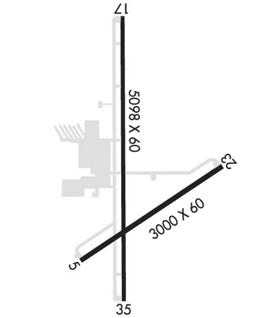
KTDW

TRADEWIND
AMARILLO
TX
Time Zone: Central
Lat: N 3510.2
Long: W 10149.6
Elev: 3649
Var: -08
Longest Runway: 5098
Clr Del: 125.4
CTAF: 122.8

FBO & Flight Services info for KTDW

FBOs: Update your Fuel Prices

TRADEWIND AIRPORTPh: 806-376-1008 Fax: 806-376-1009 Freq: 122.8
Service
Jet
100LL
SAF
MoGas
Fuel Avail: JET A INCLUDES PRIST. 7am-10pm daily,
Full5.376.06    Last Update: 04/10/2024 12:23

Self5.175.21    
 Address: 4105 TRADEWIND RD-AIRPORT,   AMARILLO, TX 79118
If you are an FBO, call 1-203-262-1700 to update your info or email: FltPlan.Advertising@garmin.com
Advertise your FBO on FltPlan.com

Runway & Approach Info for KTDW
Rwy
Length
Land Dist**
Approach*
  Rwy
Length
Land Dist**
Approach*
05
3000x60  3000'          
 
  
23
  3000x60  3000'          
 
17
5098x60  4808'          
 
  
35
  5098x60  4809'          
 
 * only ILS, LOC, LDA, and SDF approaches to a specific runway are shown
** For any Declared Landing Distance Available, please see A/FD or Approach plates
Runway Weight Capability (lbs.) Help
Runway IDSingle WheelDouble WheelDouble Tandem WheelDual Double Wheel
05/2320,000N/AN/AN/A
17/3516,000N/AN/AN/A
H1N/AN/AN/AN/A
These numbers are Advisory and are not limits.   The Airport Manager should have more accurate Weight Limits
Approach Charts
Approaches    
Current Weather/Notams
Customs Information Send updates to Support@FltPlan.com
Customs Not Available
Database effective 04/18/2024
Airport Diagram of KTDW
Airport Diagram might not be current.

Facility Name: TRADEWIND
City Name: AMARILLO
County: RANDALL
State abbrev: TX
State Name: TEXAS
   
Ownership: PRIVATELY OWNED
Use: OPEN TO THE PUBLIC
Owner's Name: TRADEWIND FBO DBA TRADEWIND ARPT
Address: 4105 TRADEWIND ST
 AMARILLO, TX 79118
Owner's Phone: 806-376-1008
  
Manager's Name: JON KUEHLER; JON.KUEHLER@GMAIL.COM; ALSO BJ@TRADEWINDAIRPORT.COM.
Address: 4105 TRADEWIND ST
 AMARILLO, TX 79118
Phone: 806-376-1008
   
FAA Region: SOUTHWEST
FAA Field Office: TEX


Sunrise / Sunset times for TRADEWIND

DateSunriseSunset
04/15/24 Monday7:1420:21
04/16/24 Tuesday7:1320:22
04/17/24 Wednesday7:1220:22
04/18/24 Thursday7:1020:23
04/19/24 Friday7:0920:24
04/20/24 Saturday7:0820:25
04/21/24 Sunday7:0720:26
04/22/24 Monday7:0520:26
04/23/24 Tuesday7:0420:27
04/24/24 Wednesday7:0320:28
04/25/24 Thursday7:0220:29
04/26/24 Friday7:0120:30
04/27/24 Saturday7:0020:30
04/28/24 Sunday6:5920:31

Airport Facilities

Airport Attendance Schedule7 Days A Week 0700-2200; AFT HRS SVC 806-376-1008.
Airport Status OPERATIONAL (This Status can change at any time - please check NOTAMS)
Airport Lighting ScheduleACTVT MIRL RWYS 05/23 & 17/35 - CTAF.
Airport Storage AvailableTie Downs, Hanger
Extra Services AvailableAir Freight, Air Ambulance, Charter, Flight Instruction, Aircraft Rental
Wind IndicatorYES - (lighted)
Control TowerNO
CTAF Frequency122.800
Unicom Frequency122.800
Rotating Beacon ColorWG
Segmented CircleYES
Landing FeeNO

Airport Inspection Data

Airport InspectedSTATE - performed by PRIVATE CONTRACT PERSONNEL
Inspection Date09/10/2021

Airport Services

Type of Fuel AvailableGrade 100LL, JET A-1 (icing inhibitor, freeze point -50C)
Airframe Repair ServiceMAJOR
Power Plant Repair ServiceMAJOR

Geographic Data

LatitudeN3510.2
LongitudeW10149.6 (ESTIMATED)
Arpt Elevation3648ft (SURVEYED)
Magnetic Variation08E
3 miles SEof AMARILLO
Traffic Pattern Altitude
Sectional ChartDALLAS-FT WORTH

Aircraft Data

Operations (Reported)YearlyAvg. Daily
General Aviation Transient 950026
General Aviation Local 2000055
Air Taxi 00
Commerical 00
Commuter 00
Military 250
Aircraft based on Field
General Aviation Singles 90
General Aviation Multi 10
Jet Aircraft 10
General Aviation Helicopters 5
Military Aircraft 0
Gliders 0
Ultralights 0

FAA Services

FSS on field NO
FSS tie-in FORT WORTH
FSS Phone 1-800-WX-BRIEF
Who issues Notams FTW
Notam D service at airport YES
ARTCC Name ALBUQUERQUE

Federal Status

Airport Certification
Aircraft Rescue & Firefighting IndexNone
Airport of EntryNo
Custom Landing RightsNo
Joint Civil/MilitaryNo
Military Landing rightsNo

Federal Agreements

GRANT AGREEMENT HAS EXPIRED; HOWEVER, AGREEMENT REMAINS IN EFFECT FOR THIS FACILITY AS LONG AS IT IS PUBLIC USE.
ASSURANCES PURSUANT TO TITLE VI, CIVIL RIGHTS ACT OF 1964

Remarks

THIS AIRPORT HAS BEEN SURVEYED BY THE NATIONAL GEODETIC SURVEY.
RWY 05/23 PERIMETER FENCE OBSTRUCTS PRIM SFC.
RWY 17/35 PERIMETER FENCE OBSTRUCTS PRIM SFC.
HOUSING AND SCHOOL SURROUNDS RWY 23 END.
FOR CD CTC ALBUQUERQUE ARTCC AT 505-856-4861.
Airport Communications & Frequencies:
Clearance Delivery Frequencies:
125.4
CTAF Frequency:
122.800
Unicom Frequency:
122.800
Remarks
  • APCH/DEP SVC PRVDD BY ALBUQUERQUE ARTCC (ZAB) ON FREQS 127.85/285.475 (AMARILLO RCAG) WHEN AMARILLO APCH CTL (AMA) CLSD.
  • AMARILLO Primary Approach Frequencies:  
    119.5
    307.0
    ALBUQUERQUE ARTCC Part-time Approach Frequencies:  
    121.15
    307.9
    AMARILLO Primary Departure Frequencies:  
    119.5
    307.0
    ALBUQUERQUE ARTCC Part-time Departure Frequencies:  
    121.15
    Runway Identifications
    Runway Identification: 05/23
    Length: 3000 ft
    Width: 60 ft
    Surface: ASPHALT-GOOD CONDITION
    Edge lights: Medium Intensity

    Treatment: NONE

     Runway: 05   Runway: 23
    Mag heading: 48°Mag heading: 228°
    Rwy Slope: -.52% DownRwy Slope: .52% Up
    Approach: Approach:
    Pattern: Left TrafficPattern: Right Traffic; RIGHT TFC PATS ESTABD TO AVOID AMARILLO INTL ILS FINAL APCH COURSE.
    Markings: NONEMarkings: NONE
    Marking Condition: POORMarking Condition: POOR
    Arresting Dev: Arresting Dev:
    Lat & Long: N3509.9  W10149.7Lat. & Long.: N3510.2  W10149.2
    Elev: 3642.6 ft. MSLElev: 3626.9 ft. MSL
    TCH: TCH:
    Visual Glide Path: Visual Glide Path:
    Displaced Threshold: NoDisplaced Threshold: No
    Touchdown Zone: YESTouchdown Zone: YES
    Touchdown Elev.: 3642.6 feetTouchdown Elev.: 3642.6 feet
    Visual Glide Slope: Visual Glide Slope:
    RVR Equipment: RVR Equipment:
    RVV Equipment: NORVV Equipment: NO
    Approach Lights: Approach Lights:
    REIL: NOREIL: NO
    Centerline Lights: NOCenterline Lights: NO
    Touchdown lights: NOTouchdown lights: NO
    Runway Category: Runway with a Visual ApproachRunway Category: Runway with a Visual Approach
    Declared Distances: Declared Distances:
    Obstructions: FENCEObstructions: POLE
    Marked: NOT Marked/LightedMarked: NOT Marked/Lighted
    Clearance slope: Clearance slope: 29:1
    Obstruction height: 4 feet AGLObstruction height: 23 feet AGL
    Dist. from runway: 200 feetDist. from runway: 854 feet
    Centerline offset: 99 right of centerlineCenterline offset: 29 feet left of centerline
    Comments: 4 FT FENCE 99 FT R AT THR.Comments: 6 FT FENCE 94 FT DSTC, 60 FT LEFT.
    Runway Identification: 17/35
    Length: 5098 ft
    Width: 60 ft
    Surface: ASPHALT-GOOD CONDITION
    Edge lights: Medium Intensity

    Treatment: NONE

     Runway: 17   Runway: 35
    Mag heading: 172°Mag heading: 352°
    Rwy Slope: -.18% DownRwy Slope: .18% Up
    Approach: Approach:
    Pattern: Right Traffic; RIGHT TFC PATS ESTABD TO AVOID AMARILLO INTL ILS FINAL APCH COURSE.Pattern: Left Traffic
    Markings: BASICMarkings: BASIC
    Marking Condition: GOODMarking Condition: GOOD
    Arresting Dev: Arresting Dev:
    Lat & Long: N3510.7  W10149.6Lat. & Long.: N3509.8  W10149.6
    Elev: 3648.5 ft. MSLElev: 3639.2 ft. MSL
    TCH: 25 ft. AGL; HEIGHT MEASURED AT DSPLCD THR.TCH:
    Visual Glide Path: 3.00 degreesVisual Glide Path:
    Displaced Threshold: 290 feetDisplaced Threshold: 289 feet
    Touchdown Zone: YESTouchdown Zone: YES
    Touchdown Elev.: 3647.2 feetTouchdown Elev.: 3640.9 feet
    Visual Glide Slope: PULSATING/STEADY BURNING VASI ON LEFT SIDE OF RUNWAYVisual Glide Slope:
    RVR Equipment: RVR Equipment:
    RVV Equipment: NORVV Equipment: NO
    Approach Lights: Approach Lights:
    REIL: YESREIL: YES
    Centerline Lights: NOCenterline Lights: NO
    Touchdown lights: NOTouchdown lights: NO
    Runway Category: Runway with a Visual ApproachRunway Category: Runway with a Non-precision Approach
    Declared Distances: Declared Distances:
    Obstructions: FENCEObstructions: TREES
    Marked: NOT Marked/LightedMarked: NOT Marked/Lighted
    Clearance slope: APCH SLOPE 24:1 24:1 AT DSPLCD THR OVR 14 FT RD, 14:1 OVR 37 FT TREES, 550 FT DSTC, 200 FT R.Clearance slope: 15:1; APCH SLOPE 0:1 AT DSPLCD THR OVR 4 FT FENCE 189 LEFT.
    Obstruction height: 6 feet AGLObstruction height: 5 feet AGL
    Dist. from runway: 200 feetDist. from runway: 200 feet
    Centerline offset: 136 right of centerlineCenterline offset:
    Comments: 4 FT FENCE 28 FT DSTC OB; 14 FT RD 56 FT DSTC.Comments: 4 FT FENCE AT RWY END; 15 FT RD, 50 FT DSTC, 28 FT TREE 189 FT DSTC, 200 FT R.
    Runway Identification: H1 HELIPAD
    Length: 50 ft
    Width: 50 ft
    Surface: ASPHALT-FAIR CONDITION
    Edge lights:

    Treatment: NONE

    C:45/P: