Click here for more info on on SMS!

KTDF

RALEIGH RGNL AT PERSON COUNTY
ROXBORO
NC
Time Zone: Eastern
Lat: N 3617.1
Long: W 07859.1
Elev: 609
Var: +08
Longest Runway: 6005
AWOS: 126.72
CTAF: 122.7

FBO & Flight Services info for KTDF

FBOs: Update your Fuel Prices

RED MOUNTAIN AVPh: 336-364-1111 Fax: 336-364-2224 Freq: 122.7
Service
Jet
100LL
SAF
MoGas
Fuel Avail: PRIST PREMIXED
Full5.996.49    Last Update: 04/05/2024 08:11

Self        
 Address: 385 MONTGOMERY DR   TIMBERLAKE, NC 27583-0009
AWOSPh: 336-364-1651
-
Freq: 126.72  
If you are an FBO, call 1-203-262-1700 to update your info or email: FltPlan.Advertising@garmin.com
Advertise your FBO on FltPlan.com

Runway & Approach Info for KTDF
Rwy
Length
Land Dist**
Approach*
  Rwy
Length
Land Dist**
Approach*
06
6005x100  5702'          
ILS/DME
 108.70 - 060°  
  
24
  6005x100  6005'          
 
 * only ILS, LOC, LDA, and SDF approaches to a specific runway are shown
** For any Declared Landing Distance Available, please see A/FD or Approach plates
Runway Weight Capability (lbs.) Help
Runway IDSingle WheelDouble WheelDouble Tandem WheelDual Double Wheel
06/2445,00068,000N/AN/A
These numbers are Advisory and are not limits.   The Airport Manager should have more accurate Weight Limits
Approach Charts
Approaches    
Current Weather/Notams
Customs Information Send updates to Support@FltPlan.com
Customs Not Available
Database effective 04/18/2024
Airport Diagram of KTDF
Airport Diagram might not be current.

Facility Name: RALEIGH RGNL AT PERSON COUNTY
City Name: ROXBORO
County: PERSON
State abbrev: NC
State Name: NORTH CAROLINA
   
Ownership: PUBLICLY OWNED
Use: OPEN TO THE PUBLIC
Owner's Name: PERSON COUNTY
Address: COUNTY BLDG, 304 S MORGAN ST
 ROXBORO, NC 27573-5245
Owner's Phone: 336-597-1735
  
Manager's Name: BILL TOUGAS
Address: 385 MONTGOMERY DRIVE
 TIMBERLAKE, NC 27583-5245
Phone: 336-364-1111
   
FAA Region: SOUTHERN
FAA Field Office: MEM


Sunrise / Sunset times for RALEIGH RGNL AT PERSON COUNTY

DateSunriseSunset
04/18/24 Thursday6:3819:53
04/19/24 Friday6:3619:54
04/20/24 Saturday6:3519:55
04/21/24 Sunday6:3419:56
04/22/24 Monday6:3319:57
04/23/24 Tuesday6:3119:57
04/24/24 Wednesday6:3019:58
04/25/24 Thursday6:2919:59
04/26/24 Friday6:2820:00
04/27/24 Saturday6:2720:01
04/28/24 Sunday6:2520:02
04/29/24 Monday6:2420:03
04/30/24 Tuesday6:2320:03
05/01/24 Wednesday6:2220:04

Airport Facilities

Airport Attendance Schedule7 Days A Week 0900-1700; ARPT UNATTENDED THANKSGIVING & CHRISTMAS.
Airport Status OPERATIONAL (This Status can change at any time - please check NOTAMS)
Airport Lighting ScheduleREIL RWY 24; MIRL RWY 06/24 OPR SS-SR; TO ACTVT OTR TIMES AND ACTVT MALSR RWY 06; PAPI RWY 06 & 24 - CTAF.
Airport Storage AvailableTie Downs
Extra Services AvailableCargo Handling, Flight Instruction, Aircraft Rental
Wind IndicatorYES - (lighted)
Control TowerNO
CTAF Frequency122.700
Unicom Frequency122.700
Rotating Beacon ColorWG
Segmented CircleYES
Landing Fee

Airport Inspection Data

Airport InspectedSTATE - performed by STATE AERONAUTICAL PERSONNEL
Inspection Date07/30/2022

Airport Services

Type of Fuel AvailableGrade 100LL, JET A-1 (icing inhibitor, freeze point -50C)
Airframe Repair ServiceNone
Power Plant Repair ServiceNone

Geographic Data

LatitudeN3617.1
LongitudeW07859.1 (ESTIMATED)
Arpt Elevation608ft (SURVEYED)
Magnetic Variation08W
6 miles Sof ROXBORO
Traffic Pattern Altitude
Sectional ChartWASHINGTON

Aircraft Data

Operations (Reported)YearlyAvg. Daily
General Aviation Transient 1800049
General Aviation Local 1500041
Air Taxi 5502
Commerical 00
Commuter 00
Military 12003
Aircraft based on Field
General Aviation Singles 29
General Aviation Multi 4
Jet Aircraft 0
General Aviation Helicopters 0
Military Aircraft 0
Gliders 0
Ultralights 0

FAA Services

FSS on field NO
FSS tie-in RALEIGH
FSS Phone 1-800-WX-BRIEF
Who issues Notams TDF
Notam D service at airport YES
ARTCC Name WASHINGTON

Federal Status

Airport Certification
Aircraft Rescue & Firefighting IndexNone
Airport of EntryNo
Custom Landing RightsNo
Joint Civil/MilitaryNo
Military Landing rightsNo

Federal Agreements

NATIONAL PLAN OF INTEGRATED AIRPORT SYSTEMS (NPIAS)
GRANT AGREEMENTS UNDER FAAP/ADAP/AIP
ASSURANCES PURSUANT TO TITLE VI, CIVIL RIGHTS ACT OF 1964

Remarks

DEER & BIRDS ON & INVOF ARPT.
GCO AVBL ON FREQ 119.700 THRU RALEIGH APCH.
CONCRETE HELIPAD, ADJACENT AND NE OF MAIN APRON, UNLGTD, VFR ONLY.
NO LINE OF SIGHT BTN RWY ENDS.
FOR CD IF UNA VIA GCO CTC RALEIGH APCH AT 919-380-3144.
(CONTACT TITLE) FAX: 336-364-2224.
Airport Communications & Frequencies:
CTAF Frequency:
122.700
Unicom Frequency:
122.700
RALEIGH Primary Approach Frequencies:  
132.35
256.9
RALEIGH Primary Departure Frequencies:  
132.35
256.9
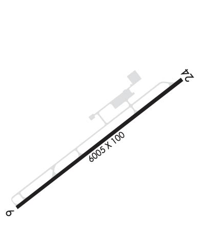
Runway Identifications
Runway Identification: 06/24
Length: 6005 ft
Width: 100 ft
Surface: ASPHALT
Edge lights: Medium Intensity

Treatment: NONE

 Runway: 06   Runway: 24
Mag heading: 60°Mag heading: 240°
Rwy Slope: .23% UpRwy Slope: -.23% Down
Approach: ILS/DMEApproach:
Pattern: Left TrafficPattern: Left Traffic
Markings: PRECISION INSTRUMENTMarkings: NONPRECISION INSTRUMENT
Marking Condition: GOODMarking Condition: GOOD
Arresting Dev: Arresting Dev:
Lat & Long: N3616.8  W07859.6Lat. & Long.: N3617.4  W07858.6
Elev: 590.4 ft. MSLElev: 604.4 ft. MSL
TCH: 41 ft. AGLTCH: 44 ft. AGL
Visual Glide Path: 3.00 degreesVisual Glide Path: 3.00 degrees
Displaced Threshold: 303 feetDisplaced Threshold: No
Touchdown Zone: YESTouchdown Zone: YES
Touchdown Elev.: 603.5 feetTouchdown Elev.: 608.9 feet
Visual Glide Slope: 4-Light PAPI on LEFT side of RunwayVisual Glide Slope: 2-Light PAPI on LEFT side of Runway
RVR Equipment: RVR Equipment:
RVV Equipment: NORVV Equipment: NO
Approach Lights: MALSR - 1,400 foot medium intensity approach lighting system with runway alignment indicator lightsApproach Lights:
REIL: NOREIL: YES
Centerline Lights: NOCenterline Lights: NO
Touchdown lights: NOTouchdown lights: NO
Runway Category: Precision Instrument RunwayRunway Category: Runway with a Non-precision Approach having visibility minimums greater than 3/4 mile
Declared Distances: Declared Distances:
Obstructions: TREESObstructions: TREES
Marked: NOT Marked/LightedMarked: NOT Marked/Lighted
Clearance slope: 37:1; 45:1 AT DSPLCD THR.Clearance slope: 29:1
Obstruction height: 58 feet AGLObstruction height: 68 feet AGL
Dist. from runway: 2360 feetDist. from runway: 2198 feet
Centerline offset: 822 left of centerlineCenterline offset: 77 feet right of centerline
Comments: Comments: DUE TO 4 FT BRUSH LCTD 0-100 FT FM END OF RWY OFFSET 175 FT RIGHT OF CNTRLN AND 3 FT BRUSH LCTD 73 FT FM END OF RWY OFFSET 164 FT LEFT OF CNTRLN.
C:6/P: