Click here for more info on on SMS!

KTCY

TRACY MUNI
TRACY
CA
Time Zone: Pacific
Lat: N 3741.3
Long: W 12126.5
Elev: 194
Var: -15
Longest Runway: 4001
AWOS: 118.37
CTAF: 123.07

FBO & Flight Services info for KTCY

FBOs: Update your Fuel Prices

SKYVIEW AVIATIONPh: 209-830-7666 Fax: 209-835-7667 Freq: 123.07
Service
Jet
100LL
SAF
MoGas
Fuel Avail: no prist available
Full        Last Update: 04/14/2024 15:00

Self5.396.60    
 Address: 5749 S TRACY BLVD,   TRACY, CA 95377
AWOSPh: 209-831-4335
-
Freq: 118.37  
If you are an FBO, call 1-203-262-1700 to update your info or email: FltPlan.Advertising@garmin.com
Advertise your FBO on FltPlan.com

Runway & Approach Info for KTCY
Rwy
Length
Land Dist**
Approach*
  Rwy
Length
Land Dist**
Approach*
08
3438x75  3438'          
 
  
26
  3438x75  3438'          
 
12
4001x75  4001'          
 
  
30
  4001x75  3740'          
 
 * only ILS, LOC, LDA, and SDF approaches to a specific runway are shown
** For any Declared Landing Distance Available, please see A/FD or Approach plates
Runway Weight Capability (lbs.) Help
Runway IDSingle WheelDouble WheelDouble Tandem WheelDual Double Wheel
08/2650,00070,000120,000N/A
12/3050,00070,000120,000N/A
These numbers are Advisory and are not limits.   The Airport Manager should have more accurate Weight Limits
Approach Charts
Approaches    
Current Weather/Notams
Customs Information Send updates to Support@FltPlan.com
Customs Not Available
Database effective 05/16/2024
Airport Diagram of KTCY
Airport Diagram might not be current.

Facility Name: TRACY MUNI
City Name: TRACY
County: SAN JOAQUIN
State abbrev: CA
State Name: CALIFORNIA
   
Ownership: PUBLICLY OWNED
Use: OPEN TO THE PUBLIC
Owner's Name: CITY OF TRACY
Address: 333 CIVIC CENTER PLAZA
 TRACY, CA 95376-4917
Owner's Phone: (209) 831-6200
  
Manager's Name: PAULA JESSUP
Address: 5749 SOUTH TRACY BLVD
 TRACY, CA 95376-4917
Phone: (209) 831-6215
   
FAA Region: WESTERN-PACIFIC
FAA Field Office: SFO


Sunrise / Sunset times for TRACY MUNI

DateSunriseSunset
04/25/24 Thursday6:1619:51
04/26/24 Friday6:1519:52
04/27/24 Saturday6:1419:53
04/28/24 Sunday6:1319:54
04/29/24 Monday6:1219:55
04/30/24 Tuesday6:1019:56
05/01/24 Wednesday6:0919:57
05/02/24 Thursday6:0819:58
05/03/24 Friday6:0719:59
05/04/24 Saturday6:0620:00
05/05/24 Sunday6:0520:00
05/06/24 Monday6:0420:01
05/07/24 Tuesday6:0320:02
05/08/24 Wednesday6:0220:03

Airport Facilities

Airport Attendance Schedule7 Days A Week 0800-1800
Airport Status OPERATIONAL (This Status can change at any time - please check NOTAMS)
Airport Lighting Schedule
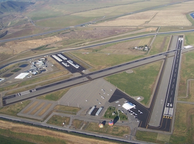
ACTVT REIL RWY 08, 26, 12, & 30; PAPI RWY 08, 12 & 26; MIRL RWY 08/26 & 12/30 - CTAF. PAPI RWY 30 IS OPRD AT NGT BY CTAF FROM SS TO SR AND IS ON DRG DALGT HRS.
Airport Storage AvailableTie Downs
Extra Services AvailableFlight Instruction, Aircraft Rental
Wind IndicatorYES - (lighted)
Control TowerNO
CTAF Frequency123.075
Unicom Frequency123.075
Rotating Beacon ColorWG
Segmented CircleYES
Landing FeeNO

Airport Inspection Data

Airport InspectedSTATE - performed by STATE AERONAUTICAL PERSONNEL
Inspection Date10/17/2023

Airport Services

Type of Fuel AvailableGrade 100LL, JET A (freeze point -40C)
Airframe Repair ServiceMAJOR
Power Plant Repair ServiceMAJOR

Geographic Data

LatitudeN3741.3
LongitudeW12126.5 (ESTIMATED)
Arpt Elevation193ft (SURVEYED)
Magnetic Variation15E
3 miles SWof TRACY
Traffic Pattern Altitude800
Sectional ChartSAN FRANCISCO

Aircraft Data

Operations (Reported)YearlyAvg. Daily
General Aviation Transient 38009104
General Aviation Local 1984054
Air Taxi 8162
Commerical 00
Commuter 00
Military 00
Aircraft based on Field
General Aviation Singles 64
General Aviation Multi 5
Jet Aircraft 1
General Aviation Helicopters 3
Military Aircraft 0
Gliders 0
Ultralights 3

FAA Services

FSS on field NO
FSS tie-in RANCHO MURIETA
FSS Phone 1-800-WX-BRIEF
Who issues Notams TCY
Notam D service at airport YES
ARTCC Name OAKLAND

Federal Status

Airport Certification
Aircraft Rescue & Firefighting IndexNone
Airport of EntryNo
Custom Landing RightsNo
Joint Civil/MilitaryNo
Military Landing rightsYES

Federal Agreements

NATIONAL PLAN OF INTEGRATED AIRPORT SYSTEMS (NPIAS)
GRANT AGREEMENTS UNDER FAAP/ADAP/AIP
SURPLUS PROPERTY AGREEMENT UNDER REGULATION 16-WAA
ASSURANCES PURSUANT TO TITLE VI, CIVIL RIGHTS ACT OF 1964

Remarks

BALLOON AND PARAPLANE ACTIVITY ON THE AIRPORT.
AEROBATIC AREA ADJ/WI 1 SMR FROM 500 AGL - 3000 MSL SR-SS.
TWO 150 FT PWR PLANT STACKS APPROX 3 NM NW OF ARPT. WATCH FOR PSBL TURB.
FOR CD CTC NORCAL APCH AT 916-361-0516.
Airport Communications & Frequencies:
CTAF Frequency:
123.075
Unicom Frequency:
123.075
NORCAL Primary Approach Frequencies:  
123.85
278.3
NORCAL Primary Departure Frequencies:  
123.85
278.3
Runway Identifications
Runway Identification: 08/26
Length: 3438 ft
Width: 75 ft
Surface: ASPHALT-GOOD CONDITION
Edge lights: Medium Intensity

Treatment: NONE

 Runway: 08   Runway: 26
Mag heading: 75°Mag heading: 255°
Rwy Slope: -.51% DownRwy Slope: .51% Up
Approach: Approach:
Pattern: Left TrafficPattern: Left Traffic
Markings: NONPRECISION INSTRUMENTMarkings: NONPRECISION INSTRUMENT
Marking Condition: GOODMarking Condition: GOOD
Arresting Dev: Arresting Dev:
Lat & Long: N3741.4  W12126.9Lat. & Long.: N3741.4  W12126.2
Elev: 190.3 ft. MSLElev: 172.7 ft. MSL
TCH: 26 ft. AGLTCH: 20 ft. AGL
Visual Glide Path: 3.40 degreesVisual Glide Path: 3.00 degrees
Displaced Threshold: NoDisplaced Threshold: No
Touchdown Zone: YESTouchdown Zone: YES
Touchdown Elev.: 190.3 feetTouchdown Elev.: 186.0 feet
Visual Glide Slope: 2-Light PAPI on LEFT side of RunwayVisual Glide Slope: 2-Light PAPI on LEFT side of Runway
RVR Equipment: RVR Equipment:
RVV Equipment: NORVV Equipment: NO
Approach Lights: Approach Lights:
REIL: YESREIL: YES
Centerline Lights: NOCenterline Lights: NO
Touchdown lights: NOTouchdown lights: NO
Runway Category: Runway with a Visual ApproachRunway Category: Runway with a Non-precision Approach
Declared Distances: Declared Distances:
Obstructions: FENCEObstructions: ROAD
Marked: NOT Marked/LightedMarked: NOT Marked/Lighted
Clearance slope: 18:1Clearance slope: 20:1
Obstruction height: 8 feet AGLObstruction height: 15 feet AGL
Dist. from runway: 350 feetDist. from runway: 500 feet
Centerline offset: 140 right of centerlineCenterline offset:
Comments: Comments:
Runway Identification: 12/30
Length: 4001 ft
Width: 75 ft
Surface: ASPHALT-GOOD CONDITION
Edge lights: Medium Intensity

Treatment: NONE

 Runway: 12   Runway: 30
Mag heading: 117°Mag heading: 297°
Rwy Slope: .32% UpRwy Slope: -.32% Down
Approach: Approach:
Pattern: Left TrafficPattern: Left Traffic
Markings: NONPRECISION INSTRUMENTMarkings: NONPRECISION INSTRUMENT
Marking Condition: GOODMarking Condition: GOOD
Arresting Dev: Arresting Dev:
Lat & Long: N3741.5  W12126.8Lat. & Long.: N3741.0  W12126.1
Elev: 180.9 ft. MSLElev: 193.6 ft. MSL
TCH: 41 ft. AGLTCH: 35 ft. AGL
Visual Glide Path: 3.00 degreesVisual Glide Path: 3.00 degrees
Displaced Threshold: NoDisplaced Threshold: 261 feet
Touchdown Zone: YESTouchdown Zone: YES
Touchdown Elev.: 193.4 feetTouchdown Elev.: 193.6 feet
Visual Glide Slope: 2-Light PAPI on LEFT side of Runway; UNUSBL BYD 5 DEGS LEFT OF CNTRLN.Visual Glide Slope: 2-Light PAPI on LEFT side of Runway
RVR Equipment: RVR Equipment:
RVV Equipment: NORVV Equipment: NO
Approach Lights: Approach Lights:
REIL: YESREIL: YES
Centerline Lights: NOCenterline Lights: NO
Touchdown lights: NOTouchdown lights: NO
Runway Category: Runway with a Non-precision ApproachRunway Category: Runway with a Non-precision Approach
Declared Distances: Declared Distances:
Obstructions: BLDGObstructions: ROAD
Marked: NOT Marked/LightedMarked: NOT Marked/Lighted
Clearance slope: 36:1Clearance slope: 20:1
Obstruction height: 25 feet AGLObstruction height: 15 feet AGL
Dist. from runway: 1100 feetDist. from runway: 510 feet
Centerline offset: Centerline offset: 280 feet right of centerline
Comments: Comments:
C:3/P: