Current Weather/Notams (Metars, TAFs, Notams, NWS Forecast, PIREPS, and nearby weather)
Customs Information Send updates to Support@FltPlan.com
Phone ###-###-####
Fax N/A
Comments No Customs Available
Database effective 05/16/2024
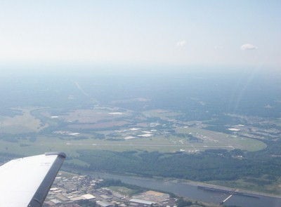
Airport Diagram might not be current.
|
| Facility Name: | TUSCALOOSA NTL |
| City Name: | TUSCALOOSA |
| County: | TUSCALOOSA |
| State abbrev: | AL |
| State Name: | ALABAMA |
| | |
| Ownership: | PUBLICLY OWNED |
| Use: | OPEN TO THE PUBLIC |
| Owner's Name: | CITY OF TUSCALOOSA |
| Address: | 7601 ROBERT CARDINAL AIRPORT ROAD |
| | TUSCALOOSA, AL 35401 |
| Owner's Phone: | (205) 248-5300 |
| | |
| Manager's Name: | TOMMY TURNER |
| Address: | 7601 ROBERT CARDINAL ARPT ROAD, SUITE 208 |
| | TUSCALOOSA, AL 35401 |
| Phone: | 205-454-9939 |
| | |
| FAA Region: | SOUTHERN |
| FAA Field Office: | JAN |
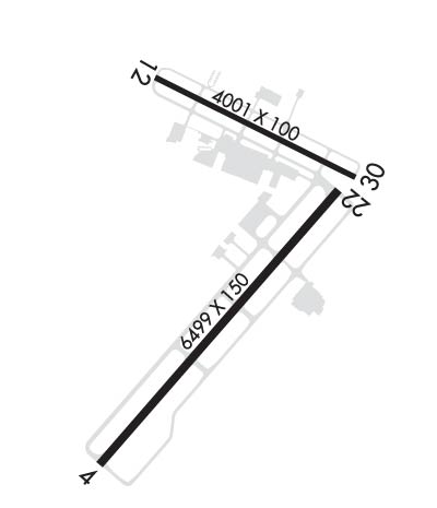
Runway Identifications
Runway Identification: 04/22Length: 6498 ft
Width: 150 ft
Surface: ASPHALT
Edge lights: High IntensityTreatment: GROOVED
Weight: PCN 50 /F/D/X/T
| | Runway: 04 | | Runway: 22 |
| Mag heading: | 41° | Mag heading: | 221° |
| Rwy Slope: | .18% Up | Rwy Slope: | -.18% Down |
| Approach: | ILS/DME | Approach: | |
| Pattern: | Left Traffic | Pattern: | Left Traffic |
| Markings: | PRECISION INSTRUMENT | Markings: | PRECISION INSTRUMENT |
| Marking Condition: | GOOD | Marking Condition: | GOOD |
| Arresting Dev: | | Arresting Dev: | |
| Lat & Long: | N3312.6 W08737.2 | Lat. & Long.: | N3313.4 W08736.3 |
| Elev: | 152.9 ft. MSL | Elev: | 164.3 ft. MSL |
| TCH: | | TCH: | 50 ft. AGL |
| Visual Glide Path: | | Visual Glide Path: | 3.00 degrees |
| Displaced Threshold: | No | Displaced Threshold: | No |
| Touchdown Zone: | YES | Touchdown Zone: | YES |
| Touchdown Elev.: | 159.5 feet | Touchdown Elev.: | 164.4 feet |
| Visual Glide Slope: | | Visual Glide Slope: | 4-Light PAPI on LEFT side of Runway |
| RVR Equipment: | | RVR Equipment: | |
| RVV Equipment: | NO | RVV Equipment: | NO |
| Approach Lights: | MALSR - 1,400 foot medium intensity approach lighting system with runway alignment indicator lights | Approach Lights: | |
| REIL: | NO | REIL: | NO |
| Centerline Lights: | NO | Centerline Lights: | NO |
| Touchdown lights: | NO | Touchdown lights: | NO |
| Runway Category: | Precision Instrument Runway | Runway Category: | Runway with a Non-precision Approach having visibility minimums greater than 3/4 mile |
| Declared Distances: | | Declared Distances: | |
| Obstructions: | | Obstructions: | TREE |
| Marked: | | Marked: | NOT Marked/Lighted |
| Clearance slope: | 50:1 | Clearance slope: | 35:1 |
| Obstruction height: | | Obstruction height: | 38 feet AGL |
| Dist. from runway: | | Dist. from runway: | 1550 feet |
| Centerline offset: | | Centerline offset: | 100 feet left of centerline |
| Comments: | | Comments: | |
Runway Identification: 12/30Length: 4000 ft
Width: 100 ft
Surface: ASPHALT-FAIR CONDITION
Edge lights: Medium IntensityTreatment: NONE
Weight: PCN 50 /F/C/X/T
| | Runway: 12 | | Runway: 30 |
| Mag heading: | 117° | Mag heading: | 297° |
| Rwy Slope: | -.04% Down | Rwy Slope: | .04% Up |
| Approach: | | Approach: | |
| Pattern: | Left Traffic | Pattern: | Left Traffic |
| Markings: | BASIC | Markings: | BASIC |
| Marking Condition: | FAIR; RWY 12 EDGE MRKGS OBSC. | Marking Condition: | FAIR; RWY 30 EDGE MRKGS OBSC. |
| Arresting Dev: | | Arresting Dev: | |
| Lat & Long: | N3313.7 W08737.0 | Lat. & Long.: | N3313.5 W08736.3 |
| Elev: | 166.6 ft. MSL | Elev: | 164.8 ft. MSL |
| TCH: | | TCH: | 73 ft. AGL |
| Visual Glide Path: | | Visual Glide Path: | 3.00 degrees |
| Displaced Threshold: | No | Displaced Threshold: | No |
| Touchdown Zone: | YES | Touchdown Zone: | YES |
| Touchdown Elev.: | 169.9 feet | Touchdown Elev.: | 169.9 feet |
| Visual Glide Slope: | | Visual Glide Slope: | 4-Light PAPI on RIGHT side of Runway |
| RVR Equipment: | | RVR Equipment: | |
| RVV Equipment: | NO | RVV Equipment: | NO |
| Approach Lights: | | Approach Lights: | |
| REIL: | NO | REIL: | NO |
| Centerline Lights: | NO | Centerline Lights: | NO |
| Touchdown lights: | NO | Touchdown lights: | NO |
| Runway Category: | Runway with a Non-precision Approach | Runway Category: | Runway with a Non-precision Approach |
| Declared Distances: | | Declared Distances: | |
| Obstructions: | TREE | Obstructions: | TREES |
| Marked: | NOT Marked/Lighted | Marked: | NOT Marked/Lighted |
| Clearance slope: | 16:1 | Clearance slope: | 25:1 |
| Obstruction height: | 40 feet AGL | Obstruction height: | 61 feet AGL |
| Dist. from runway: | 850 feet | Dist. from runway: | 1725 feet |
| Centerline offset: | 200 right of centerline | Centerline offset: | 180 feet left of centerline |
| Comments: | | Comments: | |