Current Weather/Notams (Metars, TAFs, Notams, NWS Forecast, PIREPS, and nearby weather)
Customs Information Send updates to Support@FltPlan.com
Customs Not Available
Database effective 04/18/2024
Airport Diagram might not be current.
|
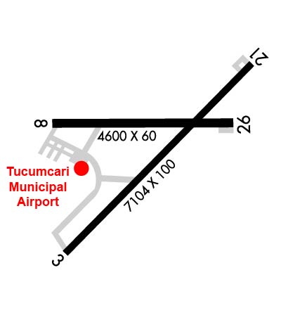
| Facility Name: | TUCUMCARI MUNI |
| City Name: | TUCUMCARI |
| County: | QUAY |
| State abbrev: | NM |
| State Name: | NEW MEXICO |
| | |
| Ownership: | PUBLICLY OWNED |
| Use: | OPEN TO THE PUBLIC |
| Owner's Name: | CITY OF TUCUMCARI |
| Address: | BOX 1188 |
| | TUCUMCARI, NM 88401 |
| Owner's Phone: | 575-461-3451 |
| | |
| Manager's Name: | JIM SEWELL |
| Address: | 6352 QRA1 ROAD |
| | TUCUMCARI, NM 88401 |
| Phone: | 575-461-3229 |
| | |
| FAA Region: | SOUTHWEST |
| FAA Field Office: | LNM |
Runway Identifications
Runway Identification: 03/21Length: 7104 ft
Width: 100 ft
Surface: ASPHALT-GOOD CONDITION
Edge lights: Medium IntensityTreatment: NONE
Weight: PCN 10 /F/C/Y/T
| | Runway: 03 | | Runway: 21 |
| Mag heading: | 33° | Mag heading: | 213° |
| Rwy Slope: | .10% Up | Rwy Slope: | -.10% Down |
| Approach: | | Approach: | |
| Pattern: | Left Traffic | Pattern: | Left Traffic |
| Markings: | NONPRECISION INSTRUMENT | Markings: | NONPRECISION INSTRUMENT |
| Marking Condition: | POOR | Marking Condition: | POOR |
| Arresting Dev: | | Arresting Dev: | |
| Lat & Long: | N3510.5 W10336.7 | Lat. & Long.: | N3511.3 W10335.7 |
| Elev: | 4039.7 ft. MSL | Elev: | 4047.0 ft. MSL |
| TCH: | | TCH: | 52 ft. AGL |
| Visual Glide Path: | | Visual Glide Path: | 3.00 degrees |
| Displaced Threshold: | No | Displaced Threshold: | No |
| Touchdown Zone: | YES | Touchdown Zone: | YES |
| Touchdown Elev.: | 4042.8 feet | Touchdown Elev.: | 4047.0 feet |
| Visual Glide Slope: | | Visual Glide Slope: | 4-BOX VASI ON LEFT SIDE OF RUNWAY |
| RVR Equipment: | | RVR Equipment: | |
| RVV Equipment: | NO | RVV Equipment: | NO |
| Approach Lights: | | Approach Lights: | |
| REIL: | NO | REIL: | NO |
| Centerline Lights: | NO | Centerline Lights: | NO |
| Touchdown lights: | NO | Touchdown lights: | NO |
| Runway Category: | Runway with a Non-precision Approach having visibility minimums greater than 3/4 mile | Runway Category: | Runway with a Non-precision Approach having visibility minimums greater than 3/4 mile |
| Declared Distances: | | Declared Distances: | |
| Obstructions: | TREE | Obstructions: | TREE |
| Marked: | NOT Marked/Lighted | Marked: | NOT Marked/Lighted |
| Clearance slope: | 33:1 | Clearance slope: | 15:1 |
| Obstruction height: | 19 feet AGL | Obstruction height: | 9 feet AGL |
| Dist. from runway: | 840 feet | Dist. from runway: | 335 feet |
| Centerline offset: | 100 right of centerline | Centerline offset: | 200 feet right of centerline |
| Comments: | | Comments: | |
Runway Identification: 08/26Length: 4600 ft
Width: 60 ft
Surface: ASPHALT-GOOD CONDITION
Edge lights: Medium IntensityTreatment: NONE
Weight: PCN 6 /F/D/Y/T
| | Runway: 08 | | Runway: 26 |
| Mag heading: | 78° | Mag heading: | 258° |
| Rwy Slope: | -.63% Down | Rwy Slope: | .63% Up |
| Approach: | | Approach: | |
| Pattern: | Left Traffic | Pattern: | Left Traffic |
| Markings: | NONPRECISION INSTRUMENT | Markings: | NONPRECISION INSTRUMENT |
| Marking Condition: | FAIR | Marking Condition: | FAIR |
| Arresting Dev: | | Arresting Dev: | |
| Lat & Long: | N3511.1 W10336.7 | Lat. & Long.: | N3511.1 W10335.8 |
| Elev: | 4064.9 ft. MSL | Elev: | 4036.0 ft. MSL |
| TCH: | | TCH: | |
| Visual Glide Path: | | Visual Glide Path: | |
| Displaced Threshold: | No | Displaced Threshold: | No |
| Touchdown Zone: | YES | Touchdown Zone: | YES |
| Touchdown Elev.: | 4064.9 feet | Touchdown Elev.: | 4054.8 feet |
| Visual Glide Slope: | | Visual Glide Slope: | |
| RVR Equipment: | | RVR Equipment: | |
| RVV Equipment: | NO | RVV Equipment: | NO |
| Approach Lights: | | Approach Lights: | |
| REIL: | NO | REIL: | NO |
| Centerline Lights: | NO | Centerline Lights: | NO |
| Touchdown lights: | NO | Touchdown lights: | NO |
| Runway Category: | Runway with a Visual Approach | Runway Category: | Runway with a Non-precision Approach |
| Declared Distances: | | Declared Distances: | |


