Current Weather/Notams (Metars, TAFs, Notams, NWS Forecast, PIREPS, and nearby weather)
Customs Information Send updates to Support@FltPlan.com
Customs Not Available
Database effective 05/16/2024
Airport Diagram might not be current.
|
| Facility Name: | YOAKUM MUNI |
| City Name: | YOAKUM |
| County: | LAVACA |
| State abbrev: | TX |
| State Name: | TEXAS |
| | |
| Ownership: | PUBLICLY OWNED |
| Use: | OPEN TO THE PUBLIC |
| Owner's Name: | CITY OF YOAKUM |
| Address: | PO BOX 738 |
| | YOAKUM, TX 77995 |
| Owner's Phone: | (361) 293-6321 |
| | |
| Manager's Name: | MICHAEL BENNETT |
| Address: | PO BOX 738 |
| | YOAKUM, TX 77995-0738 |
| Phone: | (361) 293-6321 |
| | |
| FAA Region: | SOUTHWEST |
| FAA Field Office: | TEX |
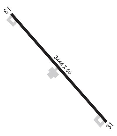
Runway Identifications
Runway Identification: 13/31Length: 3444 ft
Width: 60 ft
Surface: ASPHALT-FAIR CONDITION
Edge lights: Medium IntensityTreatment: NONE
| | Runway: 13 | | Runway: 31 |
| Mag heading: | 128° | Mag heading: | 308° |
| Rwy Slope: | -.70% Down | Rwy Slope: | .70% Up |
| Approach: | | Approach: | |
| Pattern: | Left Traffic | Pattern: | Left Traffic |
| Markings: | NONPRECISION INSTRUMENT | Markings: | NONPRECISION INSTRUMENT |
| Marking Condition: | POOR; RWY MRKGS FADED. | Marking Condition: | POOR; RWY MRKGS FADED. |
| Arresting Dev: | | Arresting Dev: | |
| Lat & Long: | N2919.0 W09708.5 | Lat. & Long.: | N2918.6 W09708.1 |
| Elev: | 365.1 ft. MSL | Elev: | 341.1 ft. MSL |
| TCH: | | TCH: | |
| Visual Glide Path: | | Visual Glide Path: | |
| Displaced Threshold: | No | Displaced Threshold: | No |
| Touchdown Zone: | YES | Touchdown Zone: | YES |
| Touchdown Elev.: | 365.4 feet | Touchdown Elev.: | 362.9 feet |
| Visual Glide Slope: | | Visual Glide Slope: | |
| RVR Equipment: | | RVR Equipment: | |
| RVV Equipment: | NO | RVV Equipment: | NO |
| Approach Lights: | | Approach Lights: | |
| REIL: | NO | REIL: | NO |
| Centerline Lights: | NO | Centerline Lights: | NO |
| Touchdown lights: | NO | Touchdown lights: | NO |
| Runway Category: | Runway with a Visual Approach | Runway Category: | Runway with a Non-precision Approach |
| Declared Distances: | | Declared Distances: | |
| Obstructions: | POLE | Obstructions: | POLE |
| Marked: | NOT Marked/Lighted | Marked: | MARKED and LIGHTED |
| Clearance slope: | 17:1 | Clearance slope: | 24:1 |
| Obstruction height: | 45 feet AGL | Obstruction height: | 42 feet AGL |
| Dist. from runway: | 998 feet | Dist. from runway: | 1230 feet |
| Centerline offset: | 230 left of centerline | Centerline offset: | 170 feet right of centerline |
| Comments: | | Comments: | |

