Current Weather/Notams (Metars, TAFs, Notams, NWS Forecast, PIREPS, and nearby weather)
Customs Information Send updates to Support@FltPlan.com
Customs Not Available
Database effective 05/16/2024
Airport Diagram might not be current.
|
| Facility Name: | GILLESPIE COUNTY |
| City Name: | FREDERICKSBURG |
| County: | GILLESPIE |
| State abbrev: | TX |
| State Name: | TEXAS |
| | |
| Ownership: | PUBLICLY OWNED |
| Use: | OPEN TO THE PUBLIC |
| Owner's Name: | GILLESPIE COUNTY |
| Address: | 101 W MAIN |
| | FREDERICKSBURG, TX 78624 |
| Owner's Phone: | 830-997-7502 |
| | |
| Manager's Name: | TONY LOMBARDI |
| Address: | 101 W MAIN UNIT 9 |
| | FREDERICKSBURG, TX 78624 |
| Phone: | 830-990-5764 |
| | |
| FAA Region: | SOUTHWEST |
| FAA Field Office: | TEX |
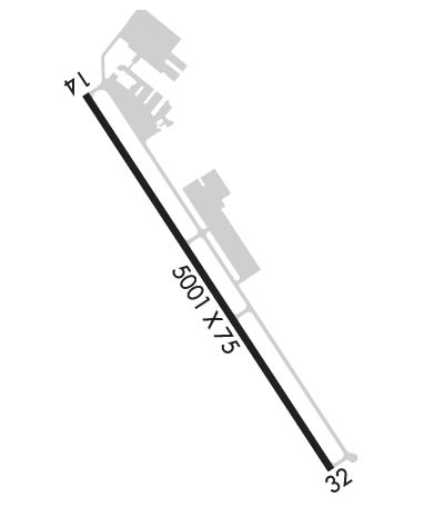
Runway Identifications
Runway Identification: 14/32Length: 5001 ft
Width: 75 ft
Surface: ASPHALT-GOOD CONDITION
Edge lights: Medium IntensityTreatment: NONE
Weight: PCN 21 /F/C/X/T
| | Runway: 14 | | Runway: 32 |
| Mag heading: | 141° | Mag heading: | 321° |
| Rwy Slope: | -.35% Down | Rwy Slope: | .35% Up |
| Approach: | | Approach: | |
| Pattern: | Right Traffic | Pattern: | Left Traffic |
| Markings: | NONPRECISION INSTRUMENT | Markings: | NONPRECISION INSTRUMENT |
| Marking Condition: | FAIR | Marking Condition: | FAIR |
| Arresting Dev: | | Arresting Dev: | |
| Lat & Long: | N3014.9 W09854.8 | Lat. & Long.: | N3014.2 W09854.3 |
| Elev: | 1694.6 ft. MSL | Elev: | 1677.1 ft. MSL |
| TCH: | 43 ft. AGL | TCH: | 37 ft. AGL |
| Visual Glide Path: | 3.00 degrees | Visual Glide Path: | 3.00 degrees |
| Displaced Threshold: | No | Displaced Threshold: | No |
| Touchdown Zone: | YES | Touchdown Zone: | YES |
| Touchdown Elev.: | 1694.7 feet | Touchdown Elev.: | 1684.6 feet |
| Visual Glide Slope: | 2-Light PAPI on LEFT side of Runway | Visual Glide Slope: | 2-Light PAPI on LEFT side of Runway |
| RVR Equipment: | | RVR Equipment: | |
| RVV Equipment: | NO | RVV Equipment: | NO |
| Approach Lights: | | Approach Lights: | |
| REIL: | NO | REIL: | NO |
| Centerline Lights: | NO | Centerline Lights: | NO |
| Touchdown lights: | NO | Touchdown lights: | NO |
| Runway Category: | Runway with a Non-precision Approach having visibility minimums greater than 3/4 mile | Runway Category: | Runway with a Non-precision Approach having visibility minimums greater than 3/4 mile |
| Declared Distances: | | Declared Distances: | |
| Obstructions: | FENCE; ALSO 30 FT TREES 680 FT DSTC ACRS APCH. | Obstructions: | ROAD |
| Marked: | LIGHTED | Marked: | NOT Marked/Lighted |
| Clearance slope: | | Clearance slope: | 13:1 |
| Obstruction height: | 3 feet AGL | Obstruction height: | 12 feet AGL |
| Dist. from runway: | 200 feet | Dist. from runway: | 357 feet |
| Centerline offset: | 216 right of centerline | Centerline offset: | 250 feet right of centerline |
| Comments: | RWY 14 +3 FT FENCE 190-200 FT FM THR, 216 FT RIGHT. | Comments: | |

