Current Weather/Notams (Metars, TAFs, Notams, NWS Forecast, PIREPS, and nearby weather)
Customs Information Send updates to Support@FltPlan.com
Customs Not Available
Database effective 04/18/2024
Airport Diagram might not be current.
|
| Facility Name: | ALFRED C 'BUBBA' THOMAS |
| City Name: | SINTON |
| County: | SAN PATRICIO |
| State abbrev: | TX |
| State Name: | TEXAS |
| | |
| Ownership: | PUBLICLY OWNED |
| Use: | OPEN TO THE PUBLIC |
| Owner's Name: | SAN PATRICIO COUNTY |
| Address: | SAN PATRICIO COUNTY COURTHOUSE, 400 W SINTON ST |
| | SINTON, TX 78387 |
| Owner's Phone: | 361-364-9300 |
| | |
| Manager's Name: | GARY LEE DAVIS |
| Address: | 3141 FM 3512 |
| | ARANSAS PASS, TX 78336 |
| Phone: | 361-226-0112 |
| | |
| FAA Region: | SOUTHWEST |
| FAA Field Office: | TEX |
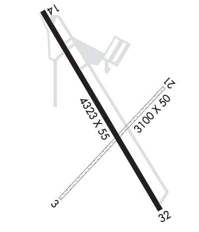
Runway Identifications
Runway Identification: 03/21Length: 3100 ft
Width: 50 ft
Surface: GRASS
Edge lights: Treatment: NONE
| | Runway: 03 | | Runway: 21 |
| Mag heading: | 35° | Mag heading: | 215° |
| Rwy Slope: | .00% | Rwy Slope: | .00% |
| Approach: | | Approach: | |
| Pattern: | Left Traffic | Pattern: | Left Traffic |
| Markings: | | Markings: | |
| Marking Condition: | | Marking Condition: | |
| Arresting Dev: | | Arresting Dev: | |
| Lat & Long: | N2802.1 W09732.7 | Lat. & Long.: | N2802.5 W09732.4 |
| Elev: | 47.0 ft. MSL | Elev: | 47.0 ft. MSL |
| TCH: | | TCH: | |
| Visual Glide Path: | | Visual Glide Path: | |
| Displaced Threshold: | No | Displaced Threshold: | No |
| Touchdown Zone: | YES | Touchdown Zone: | YES |
| Touchdown Elev.: | 47.0 feet | Touchdown Elev.: | 47.0 feet |
| Visual Glide Slope: | | Visual Glide Slope: | |
| RVR Equipment: | | RVR Equipment: | |
| RVV Equipment: | NO | RVV Equipment: | NO |
| Approach Lights: | | Approach Lights: | |
| REIL: | NO | REIL: | NO |
| Centerline Lights: | NO | Centerline Lights: | NO |
| Touchdown lights: | NO | Touchdown lights: | NO |
| Runway Category: | Runway with a Visual Approach | Runway Category: | Runway with a Visual Approach |
| Declared Distances: | | Declared Distances: | |
| Obstructions: | ROAD | Obstructions: | PLINE |
| Marked: | NOT Marked/Lighted | Marked: | LIGHTED |
| Clearance slope: | 5:1 | Clearance slope: | 11:1 |
| Obstruction height: | 15 feet AGL | Obstruction height: | 35 feet AGL |
| Dist. from runway: | 78 feet | Dist. from runway: | 400 feet |
| Centerline offset: | B | Centerline offset: | |
| Comments: | | Comments: | |
Runway Identification: 14/32Length: 4323 ft
Width: 55 ft
Surface: ASPHALT-FAIR CONDITION
Edge lights: Medium IntensityTreatment: NONE
| | Runway: 14 | | Runway: 32 |
| Mag heading: | 140° | Mag heading: | 320° |
| Rwy Slope: | .01% Up | Rwy Slope: | -.01% Down |
| Approach: | | Approach: | |
| Pattern: | Left Traffic | Pattern: | Left Traffic |
| Markings: | NONPRECISION INSTRUMENT | Markings: | NONPRECISION INSTRUMENT |
| Marking Condition: | GOOD | Marking Condition: | GOOD |
| Arresting Dev: | | Arresting Dev: | |
| Lat & Long: | N2802.6 W09732.8 | Lat. & Long.: | N2802.1 W09732.3 |
| Elev: | 46.2 ft. MSL | Elev: | 46.5 ft. MSL |
| TCH: | 19 ft. AGL | TCH: | 21 ft. AGL |
| Visual Glide Path: | 3.00 degrees | Visual Glide Path: | 3.00 degrees |
| Displaced Threshold: | 250 feet | Displaced Threshold: | 400 feet |
| Touchdown Zone: | YES | Touchdown Zone: | YES |
| Touchdown Elev.: | 47.9 feet | Touchdown Elev.: | 47.6 feet |
| Visual Glide Slope: | 2-Light PAPI on LEFT side of Runway | Visual Glide Slope: | 2-Light PAPI on LEFT side of Runway |
| RVR Equipment: | | RVR Equipment: | |
| RVV Equipment: | NO | RVV Equipment: | NO |
| Approach Lights: | | Approach Lights: | |
| REIL: | YES | REIL: | YES |
| Centerline Lights: | NO | Centerline Lights: | NO |
| Touchdown lights: | NO | Touchdown lights: | NO |
| Runway Category: | Runway with a Non-precision Approach | Runway Category: | Runway with a Non-precision Approach |
| Declared Distances: | | Declared Distances: | |
| Obstructions: | ROAD; -25 FT CREEK BED 25 FT FM THR ACRS CNTRLN. | Obstructions: | ROAD |
| Marked: | NOT Marked/Lighted | Marked: | NOT Marked/Lighted |
| Clearance slope: | APCH RATIO 17:1 TO DSPLCD THR OVR 17 FT RD, 294 FT DSTC, 295 FT L. | Clearance slope: | APCH RATIO 19:1 TO DSPLCD THR OVR 15 FT RD, 285 FT DSTC, 293 FT R. |
| Obstruction height: | 20 feet AGL | Obstruction height: | 15 feet AGL |
| Dist. from runway: | 201 feet | Dist. from runway: | 200 feet |
| Centerline offset: | 195 left of centerline | Centerline offset: | 180 feet right of centerline |
| Comments: | 5 FT FENCE, 0 FT DSTC 220 FT L. | Comments: | 3 FT FENCE AND 15 FT RD 0 FT DSTC, 110 FT L. |

