Click here for more info on on SMS!

KT60

STONEWALL COUNTY
ASPERMONT
TX
Time Zone: Central
Lat: N 3310.2
Long: W 10011.8
Elev: 1744
Var: -08
Longest Runway: 4000
CTAF: 122.9

FBO & Flight Services info for KT60

FBOs: Update your Fuel Prices

ARPT (UNATTEND)
-
Freq: 122.9
Service
Jet
100LL
SAF
MoGas
Fuel Avail: NO FUEL AVAILABLE
Full        Last Update: 04/26/2024 00:15:42

Self        
If you are an FBO, call 1-203-262-1700 to update your info or email: FltPlan.Advertising@garmin.com
Advertise your FBO on FltPlan.com

Runway & Approach Info for KT60
Rwy
Length
Land Dist**
Approach*
  Rwy
Length
Land Dist**
Approach*
17
4000x60  4000'          
 
  
35
  4000x60  4000'          
 
 * only ILS, LOC, LDA, and SDF approaches to a specific runway are shown
** For any Declared Landing Distance Available, please see A/FD or Approach plates
Runway Weight Capability (lbs.) Help
Runway IDSingle WheelDouble WheelDouble Tandem WheelDual Double Wheel
17/3512,500N/AN/AN/A
These numbers are Advisory and are not limits.   The Airport Manager should have more accurate Weight Limits
Approach Charts
FltPlan does not have IFR approach charts available for KT60.
Current Weather/Notams
Customs Information Send updates to Support@FltPlan.com
Customs Not Available
Database effective 05/16/2024
Airport Diagram of KT60
Airport Diagram might not be current.

Facility Name: STONEWALL COUNTY
City Name: ASPERMONT
County: STONEWALL
State abbrev: TX
State Name: TEXAS
   
Ownership: PUBLICLY OWNED
Use: OPEN TO THE PUBLIC
Owner's Name: STONEWALL COUNTY
Address: 128 TOWN SQUARE LANE, PO BOX 366
 ASPERMONT, TX 79502
Owner's Phone: 940-989-3393
  
Manager's Name: RONNIE MOORHEAD; CO. JUDGE/AMGR.
Address: 128 TOWN SQUARE LANE, PO BOX 366
 ASPERMONT, TX 79502
Phone: 940-989-3393; EMERGENCY PHONE: 940-989-3333 (CENTRAL DISPATCH).
   
FAA Region: SOUTHWEST
FAA Field Office: TEX


Sunrise / Sunset times for STONEWALL COUNTY

DateSunriseSunset
04/25/24 Thursday6:5820:19
04/26/24 Friday6:5720:20
04/27/24 Saturday6:5620:21
04/28/24 Sunday6:5520:22
04/29/24 Monday6:5420:22
04/30/24 Tuesday6:5320:23
05/01/24 Wednesday6:5220:24
05/02/24 Thursday6:5120:25
05/03/24 Friday6:5020:25
05/04/24 Saturday6:4920:26
05/05/24 Sunday6:4820:27
05/06/24 Monday6:4820:28
05/07/24 Tuesday6:4720:28
05/08/24 Wednesday6:4620:29

Airport Facilities

Airport Attendance ScheduleUNATTENDED
Airport Status OPERATIONAL (This Status can change at any time - please check NOTAMS)
Airport Lighting ScheduleSS-SR
Airport Storage AvailableTie Downs
Extra Services AvailableNONE
Wind IndicatorYES - (lighted)
Control TowerNO
CTAF Frequency122.900
Unicom Frequency
Rotating Beacon ColorWG
Segmented CircleYES
Landing Fee

Airport Inspection Data

Airport InspectedSTATE - performed by PRIVATE CONTRACT PERSONNEL
Inspection Date11/18/2023

Airport Services

Type of Fuel AvailableNone
Airframe Repair ServiceNone
Power Plant Repair ServiceNone

Geographic Data

LatitudeN3310.2
LongitudeW10011.8 (ESTIMATED)
Arpt Elevation1744ft (ESTIMATED)
Magnetic Variation08E
1 miles NEof ASPERMONT
Traffic Pattern Altitude
Sectional ChartDALLAS-FT WORTH

Aircraft Data

Operations (Reported)YearlyAvg. Daily
General Aviation Transient 3001
General Aviation Local 00
Air Taxi 00
Commerical 00
Commuter 00
Military 00
Aircraft based on Field
General Aviation Singles 0
General Aviation Multi 0
Jet Aircraft 0
General Aviation Helicopters 0
Military Aircraft 0
Gliders 0
Ultralights 0

FAA Services

FSS on field NO
FSS tie-in FORT WORTH
FSS Phone 1-800-WX-BRIEF
Who issues Notams FTW
Notam D service at airport YES
ARTCC Name FORT WORTH

Federal Status

Airport Certification
Aircraft Rescue & Firefighting IndexNone
Airport of EntryNo
Custom Landing RightsNo
Joint Civil/MilitaryNo
Military Landing rightsNo

Federal Agreements

NATIONAL PLAN OF INTEGRATED AIRPORT SYSTEMS (NPIAS)
GRANT AGREEMENTS UNDER FAAP/ADAP/AIP
ASSURANCES PURSUANT TO TITLE VI, CIVIL RIGHTS ACT OF 1964

Remarks

GATE LOCKED. CALL AMGR FOR COMBINATION OR ACCESS.
AGRICULTURAL ACTIVITY MAY-SEP.
FOR CD CTC FORT WORTH ARTCC AT 817-858-7584.
940-200-0894 AMGR CELL.
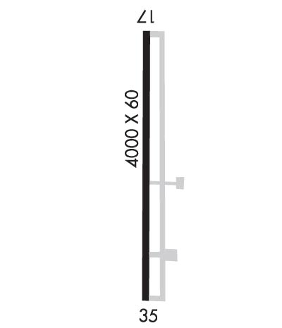
Runway Identifications
Runway Identification: 17/35
Length: 4000 ft
Width: 60 ft
Surface: ASPHALT-FAIR CONDITION
Edge lights: Medium Intensity

Treatment: NONE

 Runway: 17   Runway: 35
Mag heading: 173°Mag heading: 353°
Rwy Slope: .73% UpRwy Slope: -.73% Down
Approach: Approach:
Pattern: Left TrafficPattern: Left Traffic
Markings: NONPRECISION INSTRUMENTMarkings: NONPRECISION INSTRUMENT
Marking Condition: GOODMarking Condition: GOOD
Arresting Dev: Arresting Dev:
Lat & Long: N3310.6  W10011.8Lat. & Long.: N3309.9  W10011.8
Elev: 1715.0 ft. MSLElev: 1744.0 ft. MSL
TCH: TCH:
Visual Glide Path: Visual Glide Path:
Displaced Threshold: NoDisplaced Threshold: No
Touchdown Zone: NOTouchdown Zone: NO
Touchdown Elev.: Touchdown Elev.:
Visual Glide Slope: Visual Glide Slope:
RVR Equipment: RVR Equipment:
RVV Equipment: NORVV Equipment: NO
Approach Lights: Approach Lights:
REIL: NOREIL: NO
Centerline Lights: NOCenterline Lights: NO
Touchdown lights: NOTouchdown lights: NO
Runway Category: Runway with a Visual ApproachRunway Category: Runway with a Visual Approach
Declared Distances: Declared Distances:
Obstructions: Obstructions: PLINE
Marked: Marked: MARKED
Clearance slope: 20:1Clearance slope: 34:1
Obstruction height: Obstruction height: 20 feet AGL
Dist. from runway: Dist. from runway: 895 feet
Centerline offset: Centerline offset:
Comments: Comments:
C:1/P: