
| ||||||||||||||||||||||||||||||||
| ||||||||||||||||||||||||||||||||
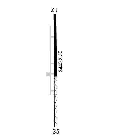
| Rwy | Rwy | |||||||
| 3440x50 | 3185' | 3440x50 | 3060' | |||||
| Runway ID | Single Wheel | Double Wheel | Double Tandem Wheel | Dual Double Wheel |
| 17/35 | N/A | N/A | N/A | N/A |
| These numbers are Advisory and are not limits. The Airport Manager should have more accurate Weight Limits | ||||
| FltPlan does not have IFR approach charts available for KT51. |
 Airport Diagram might not be current. | |
| Facility Name: | DAN JONES INTL |
| City Name: | HOUSTON |
| County: | HARRIS |
| State abbrev: | TX |
| State Name: | TEXAS |
| Ownership: | PRIVATELY OWNED |
| Use: | OPEN TO THE PUBLIC |
| Owner's Name: | DANIEL JONES |
| Address: | 16434 KITZMANN |
| CYPRESS, TX 77429 | |
| Owner's Phone: | 936-521-9887 |
| Manager's Name: | DANIEL JONES |
| Address: | 16434 KITZMAN |
| CYPRESS, TX 77429 | |
| Phone: | 936-521-9887; 936-494-8909 ASST. MGR. |
| FAA Region: | SOUTHWEST |
| FAA Field Office: | TEX |
| Date | Sunrise | Sunset |
|---|---|---|
| 04/25/24 Thursday | 6:45 | 19:57 |
| 04/26/24 Friday | 6:44 | 19:57 |
| 04/27/24 Saturday | 6:43 | 19:58 |
| 04/28/24 Sunday | 6:42 | 19:59 |
| 04/29/24 Monday | 6:41 | 19:59 |
| 04/30/24 Tuesday | 6:40 | 20:00 |
| 05/01/24 Wednesday | 6:39 | 20:01 |
| 05/02/24 Thursday | 6:38 | 20:01 |
| 05/03/24 Friday | 6:37 | 20:02 |
| 05/04/24 Saturday | 6:37 | 20:03 |
| 05/05/24 Sunday | 6:36 | 20:03 |
| 05/06/24 Monday | 6:35 | 20:04 |
| 05/07/24 Tuesday | 6:34 | 20:05 |
| 05/08/24 Wednesday | 6:33 | 20:05 |
| Airport Attendance Schedule | 7 Days A Week DAWN-0000 |
| Airport Status | OPERATIONAL (This Status can change at any time - please check NOTAMS) |
| Airport Lighting Schedule | SS-SR, ACTVT LIRL RWY 17/35- CTAF.; FOR ROTG BCN CALL 936-521-9887. |
| Airport Storage Available | Tie Downs |
| Extra Services Available | Air Ambulance |
| Wind Indicator | YES - (unlit) |
| Control Tower | NO |
| CTAF Frequency | 122.800 |
| Unicom Frequency | 122.800 |
| Rotating Beacon Color | WG |
| Segmented Circle | NO |
| Landing Fee | YES |
| Airport Inspected | STATE - performed by STATE AERONAUTICAL PERSONNEL |
| Inspection Date | 04/09/2023 |
| Type of Fuel Available | Grade 100LL |
| Airframe Repair Service | MAJOR |
| Power Plant Repair Service | MAJOR |
| Latitude | N3002.6 |
| Longitude | W09540.0 (ESTIMATED) |
| Arpt Elevation | 166ft (SURVEYED) |
| Magnetic Variation | 05E |
| 22 miles NW | of HOUSTON |
| Traffic Pattern Altitude | |
| Sectional Chart | HOUSTON |
| Operations (Reported) | Yearly | Avg. Daily |
|---|---|---|
| General Aviation Transient | 2400 | 7 |
| General Aviation Local | 5400 | 15 |
| Air Taxi | 0 | 0 |
| Commerical | 0 | 0 |
| Commuter | 0 | 0 |
| Military | 0 | 0 |
| Aircraft based on Field | |
|---|---|
| General Aviation Singles | 17 |
| General Aviation Multi | 1 |
| Jet Aircraft | 0 |
| General Aviation Helicopters | 0 |
| Military Aircraft | 0 |
| Gliders | 0 |
| Ultralights | 0 |
| FSS on field | NO |
| FSS tie-in | MONTGOMERY COUNTY |
| FSS Phone | 1-800-WX-BRIEF |
| Who issues Notams | CXO |
| Notam D service at airport | YES |
| ARTCC Name | HOUSTON |
| Airport Certification | |
| Aircraft Rescue & Firefighting Index | None |
| Airport of Entry | No |
| Custom Landing Rights | No |
| Joint Civil/Military | No |
| Military Landing rights | No |
| THIS AIRPORT HAS BEEN SURVEYED BY THE NATIONAL GEODETIC SURVEY. |
| FOR CD CTC HOUSTON APCH AT 281-443-5844 TO CNL IFR CALL 281-443-5888. |
| RWY 17/35 4 FT FENCE 53 FT EAST OF CNTRLN. |
| DEER ON RWYS. |
| NORTH-SOUTH TRANSITIONAL ACFT WEST OF FIELD. |
| LEFT HAND TFC 500 FT & 1000 FT MSL. |
| CATTLE INVOF RWY. |
| ARPT CLSD MIDNIGHT TO DAWN. |
| PPR FOR ROTOR WING ACFT. |
| RWY 17/3 5 RWY 17/35 2365 FT X 30 FT ASPH ON N END. |
| RWY 17/3 5 NORTH END 2365 FT X 30 FT ASPH. |
| RWY 17/3 5 RWY 17/35 NSTD LIRL; NSTD COLORS, SINGLE THR LGT EACH RWY END. 2240 FT OF RWY USBL FOR NGT OPNS. RWY 17 THR RELCTD 300 FT FOR NGT OPNS; RWY 35 THR RELCTD 900 FT FOR NGT OPNS. |
| Runway: 17 | Runway: 35 | ||
| Mag heading: | 174° | Mag heading: | 354° |
| Rwy Slope: | .15% Up | Rwy Slope: | -.15% Down |
| Approach: | Approach: | ||
| Pattern: | Left Traffic | Pattern: | Left Traffic |
| Markings: | NUMBERS ONLY | Markings: | NONSTANDARD |
| Marking Condition: | FAIR; THR BAR 2 FT WIDE. | Marking Condition: | FAIR |
| Arresting Dev: | Arresting Dev: | ||
| Lat & Long: | N3002.8 W09540.0 | Lat. & Long.: | N3002.3 W09540.0 |
| Elev: | 161.0 ft. MSL | Elev: | 166.0 ft. MSL |
| TCH: | TCH: | ||
| Visual Glide Path: | Visual Glide Path: | ||
| Displaced Threshold: | 255 feet; THR DSPLCD 255 FT DAYS ONLY. | Displaced Threshold: | 380 feet; THR DSPLCD 400 FT DAYS ONLY. |
| Touchdown Zone: | YES | Touchdown Zone: | YES |
| Touchdown Elev.: | 166.0 feet | Touchdown Elev.: | 166.0 feet |
| Visual Glide Slope: | Visual Glide Slope: | ||
| RVR Equipment: | RVR Equipment: | ||
| RVV Equipment: | NO | RVV Equipment: | NO |
| Approach Lights: | Approach Lights: | ||
| REIL: | NO | REIL: | NO |
| Centerline Lights: | NO | Centerline Lights: | NO |
| Touchdown lights: | NO | Touchdown lights: | NO |
| Runway Category: | Runway with a Visual Approach | Runway Category: | Runway with a Visual Approach |
| Declared Distances: | Declared Distances: | ||
| Obstructions: | TREE | Obstructions: | PLINE |
| Marked: | NOT Marked/Lighted | Marked: | LIGHTED |
| Clearance slope: | APCH RATIO 0:1 AT DSPLCD THR, 50 FT TREES 100 FT L. | Clearance slope: | APCH RATIO 0:1 AT DAY DSPLCD THR; +4 FT FENCES 53 FT R. |
| Obstruction height: | 35 feet AGL | Obstruction height: | 21 feet AGL |
| Dist. from runway: | 201 feet | Dist. from runway: | 10 feet |
| Centerline offset: | Centerline offset: | ||
| Comments: | 4 FT FENCE AT THR 53 FT L & ACRS APCH 15 FT FM THR. | Comments: |
