Current Weather/Notams (Metars, TAFs, Notams, NWS Forecast, PIREPS, and nearby weather)
Customs Information Send updates to Support@FltPlan.com
Customs Not Available
Database effective 05/16/2024
Airport Diagram might not be current.
|
| Facility Name: | LA PORTE MUNI |
| City Name: | LA PORTE |
| County: | HARRIS |
| State abbrev: | TX |
| State Name: | TEXAS |
| | |
| Ownership: | PUBLICLY OWNED |
| Use: | OPEN TO THE PUBLIC |
| Owner's Name: | CITY OF LA PORTE |
| Address: | 604 W FAIRMONT PKWY |
| | LA PORTE, TX 77571 |
| Owner's Phone: | 281-471-9650 |
| | |
| Manager's Name: | ROY MAYO; DIRECTOR OF PUBLIC WORKS. |
| Address: | 2963 N 23RD STREET |
| | LA PORTE, TX 77571 |
| Phone: | 281-471-9650 |
| | |
| FAA Region: | SOUTHWEST |
| FAA Field Office: | TEX |
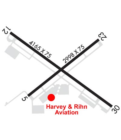
Runway Identifications
Runway Identification: 05/23Length: 2998 ft
Width: 75 ft
Surface: ASPHALT-FAIR CONDITION
Edge lights: Medium IntensityTreatment: NONE
| | Runway: 05 | | Runway: 23 |
| Mag heading: | 46° | Mag heading: | 226° |
| Rwy Slope: | .02% Up | Rwy Slope: | -.02% Down |
| Approach: | | Approach: | |
| Pattern: | Left Traffic | Pattern: | Left Traffic |
| Markings: | BASIC | Markings: | BASIC |
| Marking Condition: | GOOD | Marking Condition: | GOOD |
| Arresting Dev: | | Arresting Dev: | |
| Lat & Long: | N2940.0 W09504.1 | Lat. & Long.: | N2940.3 W09503.6 |
| Elev: | 23.2 ft. MSL | Elev: | 23.7 ft. MSL |
| TCH: | | TCH: | |
| Visual Glide Path: | | Visual Glide Path: | |
| Displaced Threshold: | No | Displaced Threshold: | No |
| Touchdown Zone: | YES | Touchdown Zone: | YES |
| Touchdown Elev.: | 23.7 feet | Touchdown Elev.: | 23.7 feet |
| Visual Glide Slope: | | Visual Glide Slope: | |
| RVR Equipment: | | RVR Equipment: | |
| RVV Equipment: | NO | RVV Equipment: | NO |
| Approach Lights: | | Approach Lights: | |
| REIL: | NO | REIL: | NO |
| Centerline Lights: | NO | Centerline Lights: | NO |
| Touchdown lights: | NO | Touchdown lights: | NO |
| Runway Category: | Runway with a Visual Approach | Runway Category: | Runway with a Visual Approach |
| Declared Distances: | | Declared Distances: | |
| Obstructions: | POLE | Obstructions: | TREES |
| Marked: | MARKED and LIGHTED | Marked: | NOT Marked/Lighted |
| Clearance slope: | 20:1 | Clearance slope: | 14:1 |
| Obstruction height: | 43 feet AGL | Obstruction height: | 39 feet AGL |
| Dist. from runway: | 1060 feet | Dist. from runway: | 760 feet |
| Centerline offset: | 68 right of centerline | Centerline offset: | 190 feet right of centerline |
| Comments: | | Comments: | |
Runway Identification: 12/30Length: 4165 ft
Width: 75 ft
Surface: ASPHALT-FAIR CONDITION
Edge lights: Medium IntensityTreatment: NONE
| | Runway: 12 | | Runway: 30 |
| Mag heading: | 121° | Mag heading: | 301° |
| Rwy Slope: | .00% Down | Rwy Slope: | .00% Up |
| Approach: | | Approach: | |
| Pattern: | Left Traffic | Pattern: | Left Traffic |
| Markings: | NONPRECISION INSTRUMENT | Markings: | NONPRECISION INSTRUMENT |
| Marking Condition: | GOOD | Marking Condition: | GOOD |
| Arresting Dev: | | Arresting Dev: | |
| Lat & Long: | N2940.4 W09504.2 | Lat. & Long.: | N2939.9 W09503.5 |
| Elev: | 24.3 ft. MSL | Elev: | 24.2 ft. MSL |
| TCH: | 47 ft. AGL | TCH: | |
| Visual Glide Path: | 3.00 degrees | Visual Glide Path: | |
| Displaced Threshold: | 190 feet | Displaced Threshold: | 402 feet |
| Touchdown Zone: | YES | Touchdown Zone: | YES |
| Touchdown Elev.: | 25.1 feet | Touchdown Elev.: | 25.1 feet |
| Visual Glide Slope: | 4-Light PAPI on LEFT side of Runway; PAPI RWY 12 UNUSBL BYD 8 DEG L OF RWY CNTRLN. | Visual Glide Slope: | |
| RVR Equipment: | | RVR Equipment: | |
| RVV Equipment: | NO | RVV Equipment: | NO |
| Approach Lights: | | Approach Lights: | |
| REIL: | YES | REIL: | NO |
| Centerline Lights: | NO | Centerline Lights: | NO |
| Touchdown lights: | NO | Touchdown lights: | NO |
| Runway Category: | Runway with a Visual Approach | Runway Category: | Runway with a Non-precision Approach |
| Declared Distances: | | Declared Distances: | |
| Obstructions: | TREES | Obstructions: | FENCE |
| Marked: | NOT Marked/Lighted | Marked: | NOT Marked/Lighted |
| Clearance slope: | 20:1; APCH RATIO 26:1 TO DSPLCD THR OVR 48 FT TREES 1275 FT 125 FT L. | Clearance slope: | APCH RATIO 34:1 T0 DSPLCD THR OVR 22 FT PLINE 748 FT 275 FT R. |
| Obstruction height: | 43 feet AGL | Obstruction height: | 6 feet AGL |
| Dist. from runway: | 1090 feet | Dist. from runway: | 201 feet |
| Centerline offset: | 126 right of centerline | Centerline offset: | 236 feet left of centerline |
| Comments: | | Comments: | 6 FT FENCE 199 FT FM THLD 246 FT LEFT OF CNTRLN. |