Click here for more info on on SMS!

KT39

ARCHER CITY MUNI
ARCHER CITY
TX
Time Zone: Central
Lat: N 3334.9
Long: W 09837.1
Elev: 1065
Var: -07
Longest Runway: 3200
CTAF: 122.9

FBO & Flight Services info for KT39

FBOs: Update your Fuel Prices

AIRPORT (UNATTND)Ph: 940-574-4990
-
Freq: 122.9
Service
Jet
100LL
SAF
MoGas
Fuel Avail: NO FUEL AVAILABLE
Full        Last Update: 04/19/2024 00:01:47

Self        
If you are an FBO, call 1-203-262-1700 to update your info or email: FltPlan.Advertising@garmin.com
Advertise your FBO on FltPlan.com

Runway & Approach Info for KT39
Rwy
Length
Land Dist**
Approach*
  Rwy
Length
Land Dist**
Approach*
17
3200x60  3200'          
 
  
35
  3200x60  3200'          
 
 * only ILS, LOC, LDA, and SDF approaches to a specific runway are shown
** For any Declared Landing Distance Available, please see A/FD or Approach plates
Runway Weight Capability (lbs.) Help
Runway IDSingle WheelDouble WheelDouble Tandem WheelDual Double Wheel
17/3512,500N/AN/AN/A
These numbers are Advisory and are not limits.   The Airport Manager should have more accurate Weight Limits
Approach Charts
FltPlan does not have IFR approach charts available for KT39.
Current Weather/Notams
Customs Information Send updates to Support@FltPlan.com
Customs Not Available
Database effective 04/18/2024
Airport Diagram of KT39
Airport Diagram might not be current.

Facility Name: ARCHER CITY MUNI
City Name: ARCHER CITY
County: ARCHER
State abbrev: TX
State Name: TEXAS
   
Ownership: PRIVATELY OWNED
Use: OPEN TO THE PUBLIC
Owner's Name: VALTER DELLE-NEBBIA
Address: P.O. BOX 734
 ARCHER CITY, TX 76351
Owner's Phone: 940-574-4990
  
Manager's Name: VALTER DELLE-NEBBIA
Address: P.O. BOX 734
 ARCHER CITY, TX 76351
Phone: 940-631-4519
   
FAA Region: SOUTHWEST
FAA Field Office: TEX


Sunrise / Sunset times for ARCHER CITY MUNI

DateSunriseSunset
04/19/24 Friday6:5820:09
04/20/24 Saturday6:5720:10
04/21/24 Sunday6:5620:11
04/22/24 Monday6:5520:11
04/23/24 Tuesday6:5420:12
04/24/24 Wednesday6:5320:13
04/25/24 Thursday6:5120:14
04/26/24 Friday6:5020:14
04/27/24 Saturday6:4920:15
04/28/24 Sunday6:4820:16
04/29/24 Monday6:4720:17
04/30/24 Tuesday6:4620:17
05/01/24 Wednesday6:4520:18
05/02/24 Thursday6:4420:19

Airport Facilities

Airport Attendance ScheduleUNATTENDED
Airport Status OPERATIONAL (This Status can change at any time - please check NOTAMS)
Airport Lighting Schedule
Airport Storage AvailableTie Downs
Extra Services AvailableCrop Dusting
Wind IndicatorYES - (lighted)
Control TowerNO
CTAF Frequency122.900
Unicom Frequency
Rotating Beacon Color
Segmented CircleNO
Landing FeeNO

Airport Inspection Data

Airport InspectedSTATE - performed by PRIVATE CONTRACT PERSONNEL
Inspection Date11/04/2023

Airport Services

Type of Fuel AvailableNone
Airframe Repair ServiceMINOR
Power Plant Repair ServiceMINOR

Geographic Data

LatitudeN3334.9
LongitudeW09837.1 (ESTIMATED)
Arpt Elevation1065ft (ESTIMATED)
Magnetic Variation07E
1 miles SEof ARCHER CITY
Traffic Pattern Altitude
Sectional ChartDALLAS-FT WORTH

Aircraft Data

Operations (Reported)YearlyAvg. Daily
General Aviation Transient 1000
General Aviation Local 1000
Air Taxi 00
Commerical 00
Commuter 00
Military 00
Aircraft based on Field
General Aviation Singles 5
General Aviation Multi 0
Jet Aircraft 0
General Aviation Helicopters 0
Military Aircraft 0
Gliders 0
Ultralights 0

FAA Services

FSS on field NO
FSS tie-in FORT WORTH
FSS Phone 1-800-WX-BRIEF
Who issues Notams FTW
Notam D service at airport YES
ARTCC Name FORT WORTH

Federal Status

Airport Certification
Aircraft Rescue & Firefighting IndexNone
Airport of EntryNo
Custom Landing RightsNo
Joint Civil/MilitaryNo
Military Landing rightsNo

Remarks

WILDLIFE ON AND INVOF ARPT.
FOR CD CTC FORT WORTH ARTCC AT 817-858-7584.
RWY 17/3 5 RWY 17/35 CLSD INDEFLY; UNDER REPAIR.
RWY 17/3 5 LOOSE GRVL, TALL GRASS ON RWY. RWY MOSTLY TURF.
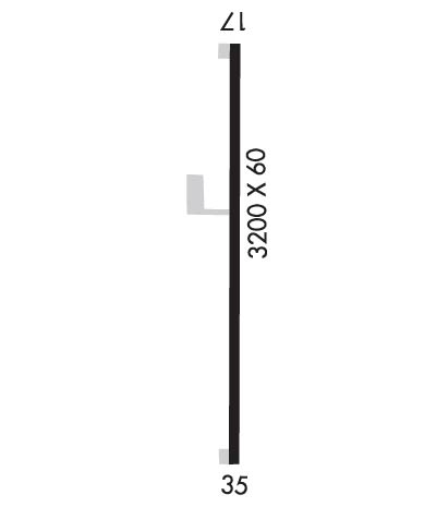
Runway Identifications
Runway Identification: 17/35
Length: 3200 ft
Width: 60 ft
Surface: ASPHALT GRASS-POOR CONDITION
Edge lights:

Treatment: NONE

 Runway: 17   Runway: 35
Mag heading: N/AMag heading: N/A
Approach: Approach:
Pattern: Left TrafficPattern: Left Traffic
Markings: NONEMarkings: NONE
Marking Condition: Marking Condition:
Arresting Dev: Arresting Dev:
Lat & Long:   Lat. & Long.:   
Elev: N/AElev: N/A
TCH: TCH:
Visual Glide Path: Visual Glide Path:
Displaced Threshold: NoDisplaced Threshold: No
Touchdown Zone: NOTouchdown Zone: NO
Touchdown Elev.: Touchdown Elev.:
Visual Glide Slope: Visual Glide Slope:
RVR Equipment: RVR Equipment:
RVV Equipment: NORVV Equipment: NO
Approach Lights: Approach Lights:
REIL: NOREIL: NO
Centerline Lights: NOCenterline Lights: NO
Touchdown lights: NOTouchdown lights: NO
Runway Category: Runway with a Visual ApproachRunway Category: Runway with a Visual Approach
Declared Distances: Declared Distances:
Obstructions: ROADObstructions:
Marked: NOT Marked/LightedMarked:
Clearance slope: 20:1Clearance slope: 50:1
Obstruction height: 15 feet AGLObstruction height:
Dist. from runway: 500 feetDist. from runway:
Centerline offset: Centerline offset:
Comments: Comments:
C:/P: