Click here for more info on on SMS!

KSZY

ROBERT SIBLEY
SELMER
TN
Time Zone: Central
Lat: N 3512.2
Long: W 08829.9
Elev: 610
Var: -01
Longest Runway: 5002
AWOS: 118.42
CTAF: 122.7

FBO & Flight Services info for KSZY

FBOs: Update your Fuel Prices

ROBERT SIBLEYPh: 731-645-3014 Fax: 731-645-3098 Freq: 122.7
Service
Jet
100LL
SAF
MoGas
Fuel Avail: PRIST injected and included in price
Full        Caution: Fuel prices have not been updated in 31 days.
Last Update: 03/26/2024 09:00

Self5.885.36    
 Address: 2282 AIRPORT RD   SELMER, TN 38375
AWOSPh: 731-645-8184
-
Freq: 118.42  
If you are an FBO, call 1-203-262-1700 to update your info or email: FltPlan.Advertising@garmin.com
Advertise your FBO on FltPlan.com

Runway & Approach Info for KSZY
Rwy
Length
Land Dist**
Approach*
  Rwy
Length
Land Dist**
Approach*
17
5002x75  5002'          
 
  
35
  5002x75  5002'          
 
 * only ILS, LOC, LDA, and SDF approaches to a specific runway are shown
** For any Declared Landing Distance Available, please see A/FD or Approach plates
Runway Weight Capability (lbs.) Help
Runway IDSingle WheelDouble WheelDouble Tandem WheelDual Double Wheel
17/3517,00023,000N/AN/A
These numbers are Advisory and are not limits.   The Airport Manager should have more accurate Weight Limits
Approach Charts
Approaches    
Current Weather/Notams
Customs Information Send updates to Support@FltPlan.com
Customs Not Available
Database effective 05/16/2024
Airport Diagram of KSZY
Airport Diagram might not be current.

Facility Name: ROBERT SIBLEY
City Name: SELMER
County: MC NAIRY
State abbrev: TN
State Name: TENNESSEE
   
Ownership: PUBLICLY OWNED
Use: OPEN TO THE PUBLIC
Owner's Name: MC NAIRY COUNTY
Address: CTY COURTHOUSE; COURT AVE
 SELMER, TN 38375
Owner's Phone: 731-645-3472
  
Manager's Name: CHRIS TULL
Address: 2282 AIRPORT ROAD
 SELMER, TN 38375
Phone: 731-645-3014
   
FAA Region: SOUTHERN
FAA Field Office: MEM


Sunrise / Sunset times for ROBERT SIBLEY

DateSunriseSunset
04/25/24 Thursday6:0919:36
04/26/24 Friday6:0719:36
04/27/24 Saturday6:0619:37
04/28/24 Sunday6:0519:38
04/29/24 Monday6:0419:39
04/30/24 Tuesday6:0319:40
05/01/24 Wednesday6:0219:40
05/02/24 Thursday6:0119:41
05/03/24 Friday6:0019:42
05/04/24 Saturday5:5919:43
05/05/24 Sunday5:5819:44
05/06/24 Monday5:5719:45
05/07/24 Tuesday5:5619:45
05/08/24 Wednesday5:5519:46

Airport Facilities

Airport Attendance ScheduleSUN 1000-1500, MON-FRI 0800-1700, SAT 0900-1600; AFT HR - 731-645-3014. CLSD 1600 M-F OCT - MAR.
Airport Status OPERATIONAL (This Status can change at any time - please check NOTAMS)
Airport Lighting ScheduleACTVT MIRL RWY 17/35 - CTAF.
Airport Storage AvailableTie Downs, Hanger
Extra Services AvailableAir Ambulance, Avionics, Flight Instruction, Aircraft Rental
Wind IndicatorYES - (lighted)
Control TowerNO
CTAF Frequency122.700
Unicom Frequency122.700
Rotating Beacon ColorWG
Segmented CircleNO
Landing FeeNO

Airport Inspection Data

Airport InspectedSTATE - performed by STATE AERONAUTICAL PERSONNEL
Inspection Date07/07/2023

Airport Services

Type of Fuel AvailableGrade 100LL, JET A
Airframe Repair ServiceMAJOR
Power Plant Repair ServiceMAJOR

Geographic Data

LatitudeN3512.2
LongitudeW08829.9 (ESTIMATED)
Arpt Elevation610ft (SURVEYED)
Magnetic Variation01E
5 miles NEof SELMER
Traffic Pattern Altitude
Sectional ChartMEMPHIS

Aircraft Data

Operations (Reported)YearlyAvg. Daily
General Aviation Transient 18005
General Aviation Local 450012
Air Taxi 1200
Commerical 00
Commuter 00
Military 1500
Aircraft based on Field
General Aviation Singles 27
General Aviation Multi 1
Jet Aircraft 0
General Aviation Helicopters 1
Military Aircraft 0
Gliders 0
Ultralights 0

FAA Services

FSS on field NO
FSS tie-in JACKSON
FSS Phone 1-800-WX-BRIEF
Who issues Notams MKL
Notam D service at airport YES
ARTCC Name MEMPHIS

Federal Status

Airport Certification
Aircraft Rescue & Firefighting IndexNone
Airport of EntryNo
Custom Landing RightsNo
Joint Civil/MilitaryNo
Military Landing rightsYES

Federal Agreements

NATIONAL PLAN OF INTEGRATED AIRPORT SYSTEMS (NPIAS)
GRANT AGREEMENTS UNDER FAAP/ADAP/AIP
ASSURANCES PURSUANT TO TITLE VI, CIVIL RIGHTS ACT OF 1964

Remarks

FOR CD CTC MEMPHIS ARTCC AT 901-368-8453/8449.
Airport Communications & Frequencies:
CTAF Frequency:
122.700
Unicom Frequency:
122.700
Remarks
  • APCH/DEP SVC PRVDD BY MEMPHIS ARTCC (ZME) ON FREQS 124.35/318.1 (MCKELLAR RCAG).
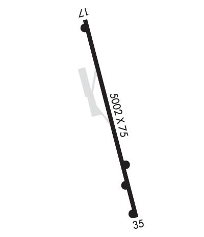
  • Runway Identifications
    Runway Identification: 17/35
    Length: 5002 ft
    Width: 75 ft
    Surface: ASPHALT
    Edge lights: Medium Intensity

    Treatment: NONE
    Weight: PCN 11 /F/D/X/T

     Runway: 17   Runway: 35
    Mag heading: 165°Mag heading: 345°
    Rwy Slope: .15% UpRwy Slope: -.15% Down
    Approach: Approach:
    Pattern: Left TrafficPattern: Left Traffic
    Markings: NONPRECISION INSTRUMENTMarkings: NONPRECISION INSTRUMENT
    Marking Condition: GOODMarking Condition: GOOD
    Arresting Dev: Arresting Dev:
    Lat & Long: N3512.6  W08830.0Lat. & Long.: N3511.8  W08829.8
    Elev: 602.4 ft. MSLElev: 609.8 ft. MSL
    TCH: 29 ft. AGLTCH: 29 ft. AGL
    Visual Glide Path: 3.00 degreesVisual Glide Path: 4.00 degrees
    Displaced Threshold: NoDisplaced Threshold: No
    Touchdown Zone: YESTouchdown Zone: YES
    Touchdown Elev.: 606.9 feetTouchdown Elev.: 610.2 feet
    Visual Glide Slope: 2-Light PAPI on LEFT side of RunwayVisual Glide Slope: 2-Light PAPI on LEFT side of Runway
    RVR Equipment: RVR Equipment:
    RVV Equipment: NORVV Equipment: NO
    Approach Lights: Approach Lights:
    REIL: YESREIL: YES
    Centerline Lights: NOCenterline Lights: NO
    Touchdown lights: NOTouchdown lights: NO
    Runway Category: Runway with a Non-precision Approach having visibility minimums greater than 3/4 mileRunway Category: Runway with a Non-precision Approach having visibility minimums greater than 3/4 mile
    Declared Distances: Declared Distances:
    Obstructions: TREEObstructions: TREE
    Marked: NOT Marked/LightedMarked: NOT Marked/Lighted
    Clearance slope: 5:1Clearance slope: 14:1
    Obstruction height: 28 feet AGLObstruction height: 30 feet AGL
    Dist. from runway: 357 feetDist. from runway: 622 feet
    Centerline offset: 71 right of centerlineCenterline offset: 70 feet left of centerline
    Comments: Comments:
    C:2/P: