Click here for more info on on SMS!

KSYM

ROWAN COUNTY
MOREHEAD
KY
Time Zone: Eastern
Lat: N 3812.9
Long: W 08335.3
Elev: 1028
Var: +06
Longest Runway: 5500
AWOS: 119.95
CTAF: 122.7

FBO & Flight Services info for KSYM

FBOs: Update your Fuel Prices

MIDWEST ACFT SVCSPh: 606-780-0085
-
Freq: 122.7
AWOSPh: 606-780-0279
-
Freq: 119.95  
If you are an FBO, call 1-203-262-1700 to update your info or email: FltPlan.Advertising@garmin.com
Advertise your FBO on FltPlan.com

Runway & Approach Info for KSYM
Rwy
Length
Land Dist**
Approach*
  Rwy
Length
Land Dist**
Approach*
02
5500x100  5500'          
 
  
20
  5500x100  5500'          
 
 * only ILS, LOC, LDA, and SDF approaches to a specific runway are shown
** For any Declared Landing Distance Available, please see A/FD or Approach plates
Runway Weight Capability (lbs.) Help
Runway IDSingle WheelDouble WheelDouble Tandem WheelDual Double Wheel
02/2043,50062,000N/AN/A
These numbers are Advisory and are not limits.   The Airport Manager should have more accurate Weight Limits
Approach Charts
Approaches    
Current Weather/Notams
Customs Information Send updates to Support@FltPlan.com
Customs Not Available
Database effective 05/16/2024
Airport Diagram of KSYM
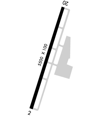
Airport Diagram might not be current.

Facility Name: MOREHEAD-ROWAN COUNTY CLYDE A THOMAS RGNL
City Name: MOREHEAD
County: ROWAN
State abbrev: KY
State Name: KENTUCKY
   
Ownership: PUBLICLY OWNED
Use: OPEN TO THE PUBLIC
Owner's Name: MOREHEAD-ROWAN COUNTY AIRPORT BOARD; BRUCE MATTINGLY
Address: 1800 RODNEY HITCH BLVD
 MOREHEAD, KY 40351
Owner's Phone: (606) 776-1232
  
Manager's Name: JACK & JODI HOLLEY
Address: 1800 RODNEY HITCH BLVD
 MOREHEAD, KY 40351
Phone: 606-780-0085; (606) 776-6211 OR (606) 356-2313.
   
FAA Region: SOUTHERN
FAA Field Office: MEM


Sunrise / Sunset times for MOREHEAD-ROWAN COUNTY CLYDE A THOMAS RGNL

DateSunriseSunset
04/30/24 Tuesday6:3820:25
05/01/24 Wednesday6:3720:26
05/02/24 Thursday6:3620:27
05/03/24 Friday6:3520:28
05/04/24 Saturday6:3420:29
05/05/24 Sunday6:3220:30
05/06/24 Monday6:3120:31
05/07/24 Tuesday6:3020:32
05/08/24 Wednesday6:2920:33
05/09/24 Thursday6:2820:34
05/10/24 Friday6:2720:35
05/11/24 Saturday6:2620:36
05/12/24 Sunday6:2520:36
05/13/24 Monday6:2520:37

Airport Facilities

Airport Attendance ScheduleSAT 1000-1600, SUN 1300-1600, MON-FRI 0800-1600
Airport Status OPERATIONAL (This Status can change at any time - please check NOTAMS)
Airport Lighting ScheduleACTVT REIL RWY 02 & 20; PAPI RWY 02 & 20; MIRL RWY 02/20 - CTAF.
Airport Storage AvailableTie Downs, Hanger
Extra Services AvailableNONE
Wind IndicatorYES - (lighted)
Control TowerNO
CTAF Frequency122.700
Unicom Frequency122.700
Rotating Beacon ColorWG
Segmented CircleYES
Landing Fee

Airport Inspection Data

Airport InspectedSTATE - performed by STATE AERONAUTICAL PERSONNEL
Inspection Date07/13/2022

Airport Services

Type of Fuel AvailableGrade 100LL, JET A; -10FUEL SVC AVBL H24 WITH CREDIT CARD.
Airframe Repair ServiceNone
Power Plant Repair ServiceNone

Geographic Data

LatitudeN3812.9
LongitudeW08335.3 (ESTIMATED)
Arpt Elevation1028ft (SURVEYED)
Magnetic Variation06W
7 miles NWof MOREHEAD
Traffic Pattern Altitude
Sectional ChartCINCINNATI

Aircraft Data

Operations (Reported)YearlyAvg. Daily
General Aviation Transient 29508
General Aviation Local 400011
Air Taxi 500
Commerical 00
Commuter 00
Military 3001
Aircraft based on Field
General Aviation Singles 23
General Aviation Multi 1
Jet Aircraft 0
General Aviation Helicopters 2
Military Aircraft 0
Gliders 0
Ultralights 0

FAA Services

FSS on field NO
FSS tie-in LOUISVILLE
FSS Phone 1-800-WX-BRIEF
Who issues Notams LOU
Notam D service at airport YES
ARTCC Name INDIANAPOLIS

Federal Status

Airport Certification
Aircraft Rescue & Firefighting IndexNone
Airport of EntryNo
Custom Landing RightsNo
Joint Civil/MilitaryNo
Military Landing rightsNo

Federal Agreements

NATIONAL PLAN OF INTEGRATED AIRPORT SYSTEMS (NPIAS)
GRANT AGREEMENTS UNDER FAAP/ADAP/AIP

Remarks

FOR CD CTC INDIANAPOLIS ARTCC AT 317-247-2411.
Airport Communications & Frequencies:
CTAF Frequency:
122.700
Unicom Frequency:
122.700
Remarks
  • APCH/DEP SVC PRVDD BY INDIANAPOLIS ARTCC ON FREQS 124.225/360.725 (PORTSMOUTH RCAG).
  • Runway Identifications
    Runway Identification: 02/20
    Length: 5500 ft
    Width: 100 ft
    Surface: ASPHALT-GOOD CONDITION
    Edge lights: Medium Intensity

    Treatment: NONE
    Weight: PCN 16 /F/C/X/T

     Runway: 02   Runway: 20
    Mag heading: 26°Mag heading: 206°
    Rwy Slope: -.33% DownRwy Slope: .33% Up
    Approach: Approach:
    Pattern: Left TrafficPattern: Left Traffic
    Markings: NONPRECISION INSTRUMENTMarkings: NONPRECISION INSTRUMENT
    Marking Condition: GOODMarking Condition: GOOD
    Arresting Dev: Arresting Dev:
    Lat & Long: N3812.5  W08335.4Lat. & Long.: N3813.3  W08335.1
    Elev: 1028.3 ft. MSLElev: 1010.4 ft. MSL
    TCH: 39 ft. AGLTCH: 39 ft. AGL
    Visual Glide Path: 3.00 degreesVisual Glide Path: 3.00 degrees
    Displaced Threshold: NoDisplaced Threshold: No
    Touchdown Zone: YESTouchdown Zone: YES
    Touchdown Elev.: 1028.3 feetTouchdown Elev.: 1020.4 feet
    Visual Glide Slope: 4-Light PAPI on LEFT side of RunwayVisual Glide Slope: 4-Light PAPI on LEFT side of Runway
    RVR Equipment: RVR Equipment:
    RVV Equipment: NORVV Equipment: NO
    Approach Lights: Approach Lights:
    REIL: YESREIL: YES
    Centerline Lights: NOCenterline Lights: NO
    Touchdown lights: NOTouchdown lights: NO
    Runway Category: DRunway Category: Runway with a Non-precision Approach having visibility minimums greater than 3/4 mile
    Declared Distances: Declared Distances:
    Obstructions: TREESObstructions: TREES
    Marked: NOT Marked/LightedMarked: NOT Marked/Lighted
    Clearance slope: 20:1Clearance slope: 1:1
    Obstruction height: 48 feet AGLObstruction height: 53 feet AGL
    Dist. from runway: 1205 feetDist. from runway: 218 feet
    Centerline offset: 635 right of centerlineCenterline offset: 455 feet right of centerline
    Comments: Comments:
    C:3/P: