Current Weather/Notams (Metars, TAFs, Notams, NWS Forecast, PIREPS, and nearby weather)
Customs Information Send updates to Support@FltPlan.com
Customs Not Available
Database effective 04/18/2024
Airport Diagram might not be current. Facility Name: SUMMERSVILLE City Name: SUMMERSVILLE County: NICHOLAS State abbrev: WV State Name: WEST VIRGINIA Ownership: PUBLICLY OWNED Use: OPEN TO THE PUBLIC Owner's Name: U.S. ARMY CORPS OF ENGINEERS.; ARPT LEASED TO NICHOLAS CO. ARPT AUTH. P O BOX 95, SUMMERSVILLE, WV 26651. 304-872-7830. USACE POC TRAVIS BOWMAN. 304-590-9353 CELL PH. Address: 502 8TH ST. HUNTINGTON, WV 25701 Owner's Phone: 304-399-5890 Manager's Name: TIM ADKINS Address: ATTN: NCAA, PO BOX 95; ARPT PHYS ADDR. 2506 AIRPORT RD. SUMMERSVILLE, WV 26651. SUMMERSVILLE, WV 26651-0754 Phone: 304-881-1600 FAA Region: EASTERN FAA Field Office: BKW
Runway Identifications Help
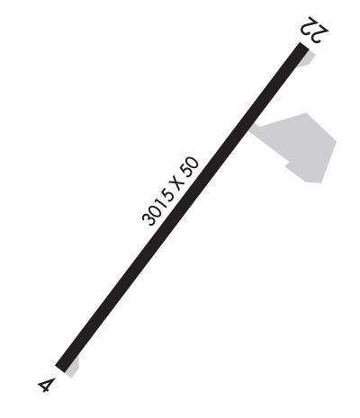
Runway Identification: 04/22 Length: 3015 ftWidth: 50 ftSurface: ASPHALT-FAIR CONDITIONEdge lights: Medium Intensity Treatment: NONE Runway: 04 Runway: 22 Mag heading: 44° Mag heading: 224° Rwy Slope: .40% Up Rwy Slope: -.40% Down Approach: SDF Approach: Pattern: Left Traffic Pattern: Left Traffic Markings: NONPRECISION INSTRUMENT Markings: NONPRECISION INSTRUMENT Marking Condition: FAIR Marking Condition: FAIR Arresting Dev: Arresting Dev: Lat & Long: N3813.7 W08052.4 Lat. & Long.: N3814.1 W08052.1 Elev: 1807.6 ft. MSL Elev: 1819.7 ft. MSL TCH: TCH: 32 ft. AGL Visual Glide Path: Visual Glide Path: 3.25 degrees Displaced Threshold: No Displaced Threshold: No Touchdown Zone: YES Touchdown Zone: YES Touchdown Elev.: 1819.7 feet Touchdown Elev.: 1819.7 feet Visual Glide Slope: Visual Glide Slope: 2-Light PAPI on LEFT side of Runway RVR Equipment: RVR Equipment: RVV Equipment: NO RVV Equipment: NO Approach Lights: Approach Lights: REIL: YES ; REILS OTS INDEFLY.REIL: YES ; REILS OTS INDEFLY.Centerline Lights: NO Centerline Lights: NO Touchdown lights: NO Touchdown lights: NO Runway Category: Runway with a Non-precision Approach Runway Category: Runway with a Non-precision Approach Declared Distances: Declared Distances: Obstructions: TREES Obstructions: TREES Marked: NOT Marked/Lighted Marked: NOT Marked/Lighted Clearance slope: Clearance slope: Obstruction height: 50 feet AGL Obstruction height: 65 feet AGL Dist. from runway: 201 feet Dist. from runway: 201 feet Centerline offset: 150 right of centerline Centerline offset: 150 feet left of centerline Comments: 30 FT TREES; UP TO 120 FT DSTC, APPROX 105 TO 125 FT RIGHT. Comments: 70 FT TREES, 0 FT DSTC 200 FT L.