Current Weather/Notams (Metars, TAFs, Notams, NWS Forecast, PIREPS, and nearby weather)
Customs Information Send updates to Support@FltPlan.com
Customs Not Available
Database effective 04/18/2024
Airport Diagram might not be current.
|
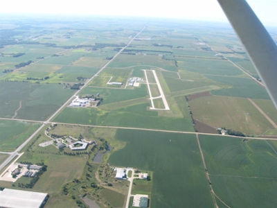
| Facility Name: | SEWARD MUNI |
| City Name: | SEWARD |
| County: | SEWARD |
| State abbrev: | NE |
| State Name: | NEBRASKA |
| | |
| Ownership: | PUBLICLY OWNED |
| Use: | OPEN TO THE PUBLIC |
| Owner's Name: | SEWARD AIRPORT AUTHORITY; ERICH HELGE, AIRPORT AUTHORITY CHAIRMAN |
| Address: | BOX 278 |
| | SEWARD, NE 68434-0278 |
| Owner's Phone: | 402-643-2125 |
| | |
| Manager's Name: | GREG AND TERRI WHISLER |
| Address: | BOX 278 |
| | SEWARD, NE 68434-0278 |
| Phone: | 402-643-2125 |
| | |
| FAA Region: | CENTRAL |
| FAA Field Office: | NONE |
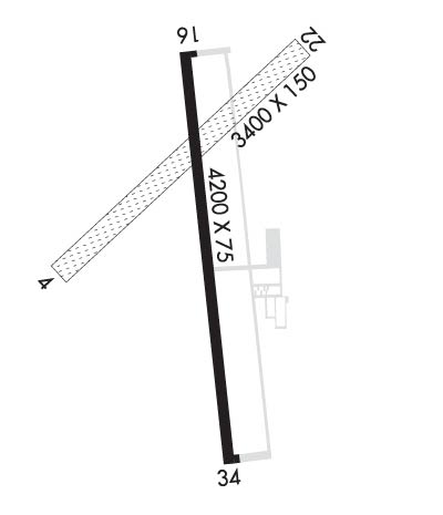
Runway Identifications
Runway Identification: 04/22Length: 3400 ft
Width: 150 ft
Surface: GRASS-GOOD CONDITION
Edge lights: Treatment: NONE
| | Runway: 04 | | Runway: 22 |
| Mag heading: | 41° | Mag heading: | 221° |
| Rwy Slope: | -.32% Down | Rwy Slope: | .32% Up |
| Approach: | | Approach: | |
| Pattern: | Left Traffic | Pattern: | Left Traffic |
| Markings: | | Markings: | |
| Marking Condition: | | Marking Condition: | |
| Arresting Dev: | | Arresting Dev: | |
| Lat & Long: | N4051.8 W09706.9 | Lat. & Long.: | N4052.2 W09706.3 |
| Elev: | 1501.0 ft. MSL | Elev: | 1490.0 ft. MSL |
| TCH: | | TCH: | |
| Visual Glide Path: | | Visual Glide Path: | |
| Displaced Threshold: | No | Displaced Threshold: | No |
| Touchdown Zone: | YES | Touchdown Zone: | YES |
| Touchdown Elev.: | 1501.0 feet | Touchdown Elev.: | 1501.0 feet |
| Visual Glide Slope: | | Visual Glide Slope: | |
| RVR Equipment: | | RVR Equipment: | |
| RVV Equipment: | NO | RVV Equipment: | NO |
| Approach Lights: | | Approach Lights: | |
| REIL: | NO | REIL: | NO |
| Centerline Lights: | NO | Centerline Lights: | NO |
| Touchdown lights: | NO | Touchdown lights: | NO |
| Runway Category: | Runway with a Visual Approach | Runway Category: | Runway with a Visual Approach |
| Declared Distances: | | Declared Distances: | |
| Obstructions: | TREE | Obstructions: | |
| Marked: | NOT Marked/Lighted | Marked: | |
| Clearance slope: | 41:1 | Clearance slope: | 50:1 |
| Obstruction height: | 66 feet AGL | Obstruction height: | |
| Dist. from runway: | 2704 feet | Dist. from runway: | |
| Centerline offset: | 19 right of centerline | Centerline offset: | |
| Comments: | | Comments: | |
Runway Identification: 16/34Length: 4200 ft
Width: 75 ft
Surface: CONCRETE-GOOD CONDITION
Edge lights: Medium IntensityTreatment: NONE
| | Runway: 16 | | Runway: 34 |
| Mag heading: | 168° | Mag heading: | 348° |
| Rwy Slope: | .27% Up | Rwy Slope: | -.27% Down |
| Approach: | | Approach: | |
| Pattern: | Left Traffic | Pattern: | Left Traffic |
| Markings: | NONPRECISION INSTRUMENT | Markings: | NONPRECISION INSTRUMENT |
| Marking Condition: | GOOD | Marking Condition: | GOOD |
| Arresting Dev: | | Arresting Dev: | |
| Lat & Long: | N4052.2 W09706.6 | Lat. & Long.: | N4051.5 W09706.5 |
| Elev: | 1494.0 ft. MSL | Elev: | 1505.4 ft. MSL |
| TCH: | 41 ft. AGL | TCH: | 41 ft. AGL |
| Visual Glide Path: | 3.00 degrees | Visual Glide Path: | 3.00 degrees |
| Displaced Threshold: | No | Displaced Threshold: | No |
| Touchdown Zone: | YES | Touchdown Zone: | YES |
| Touchdown Elev.: | 1504.6 feet | Touchdown Elev.: | 1505.5 feet |
| Visual Glide Slope: | 2-Light PAPI on LEFT side of Runway | Visual Glide Slope: | 2-Light PAPI on LEFT side of Runway |
| RVR Equipment: | | RVR Equipment: | |
| RVV Equipment: | NO | RVV Equipment: | NO |
| Approach Lights: | | Approach Lights: | |
| REIL: | NO | REIL: | NO |
| Centerline Lights: | NO | Centerline Lights: | NO |
| Touchdown lights: | NO | Touchdown lights: | NO |
| Runway Category: | Runway with a Non-precision Approach | Runway Category: | Runway with a Non-precision Approach |
| Declared Distances: | | Declared Distances: | |
| Obstructions: | ROAD | Obstructions: | ROAD |
| Marked: | NOT Marked/Lighted | Marked: | NOT Marked/Lighted |
| Clearance slope: | 44:1 | Clearance slope: | 34:1 |
| Obstruction height: | 23 feet AGL | Obstruction height: | 13 feet AGL |
| Dist. from runway: | 1225 feet | Dist. from runway: | 730 feet |
| Centerline offset: | 354B | Centerline offset: | |
| Comments: | | Comments: | |