Serving Stillwater Regional Airport since 1984

KSWO

STILLWATER RGNL
STILLWATER
OK
Time Zone: Central
Lat: N 3609.7
Long: W 09705.2
Elev: 1000
Var: -05
Longest Runway: 7401
AWOS: 135.72
Ground: 121.6
Tower: 125.35

FBO & Flight Services info for KSWO

FBOs: Update your Fuel Prices
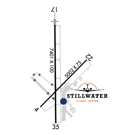
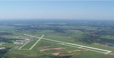
Stillwater Flight Center is recognized as the GENERAL AVIATION/JET SERVICE FBO for the Stillwater Regional Airport.
We have over 25 years experience handling aircraft from Light Sport to Corporate to B-757s. Quick Turns are available and we are ready to serve your aviation needs.
Ph: 405-624-5463 Fax: 405-372-2529 Freq: 122.95WebsiteE-Mail
                          
Service
Jet
100LL
SAF
MoGas
Fuel Avail: 7A-10P CST 7 days a week
Full5.445.89    Last Update: 04/24/2024 11:15

Self        
Misc. Info: We accept Phillips IntoPlane Fuel Customers.Address: 2020 W AIRPORT RD,   STILLWATER, OK 74075

AWOSPh: 405-743-8150
-
Freq: 135.72  
If you are an FBO, call 1-203-262-1700 to update your info or email: FltPlan.Advertising@garmin.com
Advertise your FBO on FltPlan.com

Runway & Approach Info for KSWO
Rwy
Length
Land Dist**
Approach*
  Rwy
Length
Land Dist**
Approach*
04
5002x75  5002'          
 
  
22
  5002x75  5002'          
 
17
7401x100  7401'          
ILS/DME
 109.15 - 174°  
  
35
  7401x100  7401'          
 
 * only ILS, LOC, LDA, and SDF approaches to a specific runway are shown
** For any Declared Landing Distance Available, please see A/FD or Approach plates
Runway Weight Capability (lbs.) Help
Runway IDSingle WheelDouble WheelDouble Tandem WheelDual Double Wheel
04/2234,00060,000N/AN/A
17/35100,000157,000310,000N/A
These numbers are Advisory and are not limits.   The Airport Manager should have more accurate Weight Limits
Approach Charts
Approaches    
Current Weather/Notams
Customs Information Send updates to Support@FltPlan.com
Customs Not Available
Database effective 05/16/2024
Airport Diagram of KSWO
Airport Diagram might not be current.

Facility Name: STILLWATER RGNL
City Name: STILLWATER
County: PAYNE
State abbrev: OK
State Name: OKLAHOMA
   
Ownership: PUBLICLY OWNED
Use: OPEN TO THE PUBLIC
Owner's Name: CITY OF STILLWATER
Address: 723 SOUTH LEWIS
 STILLWATER, OK 74074
Owner's Phone: 405-372-0025
  
Manager's Name: KELLIE REED
Address: 3304 N AIRPORT INDUSTRIAL ACCESS RD
 STILLWATER, OK 74075
Phone: 405-533-8425
   
FAA Region: SOUTHWEST
FAA Field Office: AOK


Sunrise / Sunset times for STILLWATER RGNL

DateSunriseSunset
04/25/24 Thursday6:4120:11
04/26/24 Friday6:4020:12
04/27/24 Saturday6:3920:13
04/28/24 Sunday6:3820:14
04/29/24 Monday6:3720:15
04/30/24 Tuesday6:3620:16
05/01/24 Wednesday6:3520:17
05/02/24 Thursday6:3420:17
05/03/24 Friday6:3320:18
05/04/24 Saturday6:3120:19
05/05/24 Sunday6:3020:20
05/06/24 Monday6:2920:21
05/07/24 Tuesday6:2920:22
05/08/24 Wednesday6:2820:22

Airport Facilities

Airport Attendance Schedule7 Days A Week 0800-2200; AFT HR FUEL - 405-377-5326.
Airport Status OPERATIONAL (This Status can change at any time - please check NOTAMS)
Airport Lighting ScheduleACTVT MALSR RWY 17; REIL RWY 35; PAPI RWY 22; MIRL RWY 04/22 & 17/35 - CTAF. MIRL RWY 17/35 PRESET LOW INTST; INCR INTST - CTAF.
Airport Storage AvailableTie Downs, Hanger
Extra Services AvailableAir Freight, Flight Instruction, Aircraft Rental, Aircraft Sales
Wind IndicatorYES - (lighted)
Control TowerYES
CTAF Frequency125.350
Unicom Frequency122.950
Rotating Beacon ColorWG
Segmented CircleNO
Landing FeeNO

Airport Inspection Data

Airport InspectedFEDERAL - performed by FAA AIRPORTS FIELD PERSONNEL
Inspection Date03/13/2024

Airport Services

Type of Fuel AvailableGrade 100LL, JET A (freeze point -40C)
Airframe Repair ServiceMAJOR
Power Plant Repair ServiceMAJOR

Geographic Data

LatitudeN3609.7
LongitudeW09705.2 (ESTIMATED)
Arpt Elevation1000ft (SURVEYED)
Magnetic Variation05E
3 miles NWof STILLWATER
Traffic Pattern Altitude800; TPA LGT ACFT 800 FT AGL, TURBO PROPS/JETS 1500 FT AGL.
Sectional ChartWICHITA

Aircraft Data

Operations (Reported)YearlyAvg. Daily
General Aviation Transient 3291590
General Aviation Local 39899109
Air Taxi 12854
Commerical 8542
Commuter 00
Military 25717
Aircraft based on Field
General Aviation Singles 85
General Aviation Multi 5
Jet Aircraft 0
General Aviation Helicopters 0
Military Aircraft 0
Gliders 0
Ultralights 0

FAA Services

FSS on field NO
FSS tie-in MC ALESTER
FSS Phone 1-800-WX-BRIEF
Who issues Notams SWO
Notam D service at airport YES
ARTCC Name KANSAS CITY

Federal Status

Airport CertificationAIRPORT RECEIVING SCHEDULED AIR CARRIER SERVICE FROM CARRIERS CERTIFICATED BY THE CIVIL AERONAUTICS BOARD; 24 HRS PPR FOR UNSKED ACFT OPS WITH MORE THAN 9 PAX CALL AMGR 405-533-2222.
Aircraft Rescue & Firefighting IndexAIRPORT HAS A CERTIFICATE UNDER CFR PART 139
Airport of EntryNo
Custom Landing RightsNo
Joint Civil/MilitaryNo
Military Landing rightsYES

Federal Agreements

NATIONAL PLAN OF INTEGRATED AIRPORT SYSTEMS (NPIAS)
GRANT AGREEMENTS UNDER FAAP/ADAP/AIP
ASSURANCES PURSUANT TO TITLE VI, CIVIL RIGHTS ACT OF 1964
AGREEMENT UNDER DLAND OR DCLA HAS EXPIRED.

Remarks

STUDENT OPS & BIRDS ON & INVOF ARPT.
ALL RAMPS UNCONTROLLED.
AFT HRS FUEL AVBL WITH PPR; CTC 405-624-5463.
FOR GA TSNT PRKG ON HANGAR 1 RAMP CTC FBO ON UNICOM OR FONE 405-624-5463.
ARFF INDEX B MAINTAINED; ARFF INDEX C PPR.
PTN OF TWY F NORTH OF T-HNGR 2 NOT VSBL FROM ATCT.
FOR CD IF UNA TO CTC ON FSS FREQ, CTC KANSAS CITY ARTCC AT 913-254-8508.
RWY 17/3 5 STRENGTHS BASED ON RESTRICTED OPS.
Airport Communications & Frequencies:
STILLWATER Tower Frequencies:   Hours(local) of operation: 0800-2200   
125.35
STILLWATER Ground Frequencies:
121.6
CTAF Frequency:
125.350
Unicom Frequency:
122.950
Remarks
  • APCH/DEP CTL SVC PRVDD BY KANSAS CITY ARTCC (ZKC) ON FREQS 127.8/319.1 (PONCA CITY RCAG).
  • Runway Identifications
    Runway Identification: 04/22
    Length: 5002 ft
    Width: 75 ft
    Surface: ASPHALT-GOOD CONDITION
    Edge lights: Medium Intensity

    Treatment: NONE

     Runway: 04   Runway: 22
    Mag heading: 40°Mag heading: 220°
    Rwy Slope: .50% UpRwy Slope: -.50% Down
    Approach: Approach:
    Pattern: Left TrafficPattern: Left Traffic
    Markings: BASICMarkings: BASIC
    Marking Condition: GOODMarking Condition: GOOD
    Arresting Dev: Arresting Dev:
    Lat & Long: N3609.3  W09705.4Lat. & Long.: N3609.9  W09704.7
    Elev: 960.9 ft. MSLElev: 985.7 ft. MSL
    TCH: 35 ft. AGLTCH: 39 ft. AGL
    Visual Glide Path: 3.00 degreesVisual Glide Path: 3.00 degrees
    Displaced Threshold: NoDisplaced Threshold: No
    Touchdown Zone: YESTouchdown Zone: YES
    Touchdown Elev.: 965.8 feetTouchdown Elev.: 985.7 feet
    Visual Glide Slope: 4-Light PAPI on LEFT side of Runway; UNUSBL BYD 9 DEGS RIGHT OF CNTRLN.Visual Glide Slope: 4-Light PAPI on LEFT side of Runway
    RVR Equipment: RVR Equipment:
    RVV Equipment: NORVV Equipment: NO
    Approach Lights: Approach Lights:
    REIL: NOREIL: NO
    Centerline Lights: NOCenterline Lights: NO
    Touchdown lights: NOTouchdown lights: NO
    Runway Category: Runway with a Visual ApproachRunway Category: Runway with a Visual Approach
    Declared Distances: TORA:5002' TODA:5002' ASDA:5002' LDA:5002'Declared Distances: TORA:5002' TODA:5002' ASDA:5002' LDA:5002'
    Obstructions: GNDObstructions:
    Marked: NOT Marked/LightedMarked:
    Clearance slope: 45:1Clearance slope: 50:1
    Obstruction height: 3 feet AGLObstruction height:
    Dist. from runway: 520 feetDist. from runway:
    Centerline offset: Centerline offset:
    Comments: Comments:
    Runway Identification: 17/35
    Length: 7401 ft
    Width: 100 ft
    Surface: CONCRETE-GOOD CONDITION
    Edge lights: Medium Intensity

    Treatment: GROOVED

     Runway: 17   Runway: 35
    Mag heading: 174°Mag heading: 354°
    Rwy Slope: -.46% DownRwy Slope: .46% Up
    Approach: ILS/DMEApproach:
    Pattern: Left TrafficPattern: Left Traffic
    Markings: PRECISION INSTRUMENTMarkings: PRECISION INSTRUMENT
    Marking Condition: GOODMarking Condition: GOOD
    Arresting Dev: Arresting Dev:
    Lat & Long: N3610.3  W09705.2Lat. & Long.: N3609.1  W09705.2
    Elev: 1000.3 ft. MSLElev: 966.0 ft. MSL
    TCH: 50 ft. AGLTCH: 38 ft. AGL
    Visual Glide Path: 3.00 degreesVisual Glide Path: 3.00 degrees
    Displaced Threshold: NoDisplaced Threshold: No
    Touchdown Zone: YESTouchdown Zone: YES
    Touchdown Elev.: 1000.3 feetTouchdown Elev.: 966.0 feet
    Visual Glide Slope: 4-Light PAPI on LEFT side of Runway; UNUSBL BYD 9 DEGS LEFT & RIGHT OF CNTRLN.Visual Glide Slope: 4-Light PAPI on LEFT side of Runway; UNUSBL BYD 9 DEGS LEFT & 8 DEGS RIGHT OF CNTRLN.
    RVR Equipment: RVR Equipment:
    RVV Equipment: NORVV Equipment: NO
    Approach Lights: MALSR - 1,400 foot medium intensity approach lighting system with runway alignment indicator lightsApproach Lights:
    REIL: NOREIL: YES
    Centerline Lights: NOCenterline Lights: NO
    Touchdown lights: NOTouchdown lights: NO
    Runway Category: Precision Instrument RunwayRunway Category: Precision Instrument Runway
    Declared Distances: TORA:7401' TODA:7401' ASDA:7401' LDA:7401'Declared Distances: TORA:7401' TODA:7401' ASDA:7401' LDA:7401'
    C:22/P: