
| |||||||||||||||||||||||||||||||||||||||||||||||||||||||||||||
| |||||||||||||||||||||||||||||||||||||||||||||||||||||||||||||
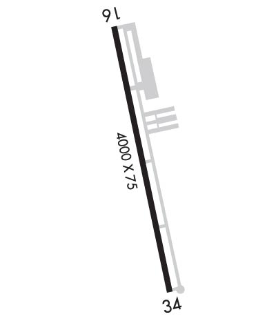
| Rwy | Rwy | |||||||
| 4000x75 | 4000' | 4000x75 | 4000' | |||||
| Runway ID | Single Wheel | Double Wheel | Double Tandem Wheel | Dual Double Wheel |
| 16/34 | 19,000 | N/A | N/A | N/A |
| These numbers are Advisory and are not limits. The Airport Manager should have more accurate Weight Limits | ||||
 Airport Diagram might not be current. | |
| Facility Name: | SHERMAN MUNI |
| City Name: | SHERMAN |
| County: | GRAYSON |
| State abbrev: | TX |
| State Name: | TEXAS |
| Ownership: | PUBLICLY OWNED |
| Use: | OPEN TO THE PUBLIC |
| Owner's Name: | CITY OF SHERMAN |
| Address: | PO BOX 1106 |
| SHERMAN, TX 75090 | |
| Owner's Phone: | 903-892-4547 |
| Manager's Name: | JOHN HOOKER |
| Address: | 1200 S. DEWEY AVE |
| SHERMAN, TX 75090 | |
| Phone: | 903-868-4412 |
| FAA Region: | SOUTHWEST |
| FAA Field Office: | TEX |
| Date | Sunrise | Sunset |
|---|---|---|
| 04/25/24 Thursday | 6:43 | 20:06 |
| 04/26/24 Friday | 6:42 | 20:06 |
| 04/27/24 Saturday | 6:41 | 20:07 |
| 04/28/24 Sunday | 6:40 | 20:08 |
| 04/29/24 Monday | 6:39 | 20:09 |
| 04/30/24 Tuesday | 6:38 | 20:09 |
| 05/01/24 Wednesday | 6:37 | 20:10 |
| 05/02/24 Thursday | 6:36 | 20:11 |
| 05/03/24 Friday | 6:35 | 20:12 |
| 05/04/24 Saturday | 6:34 | 20:12 |
| 05/05/24 Sunday | 6:33 | 20:13 |
| 05/06/24 Monday | 6:32 | 20:14 |
| 05/07/24 Tuesday | 6:31 | 20:15 |
| 05/08/24 Wednesday | 6:31 | 20:15 |
| Airport Attendance Schedule | 7 Days A Week 0800-1700 |
| Airport Status | OPERATIONAL (This Status can change at any time - please check NOTAMS) |
| Airport Lighting Schedule | MIRL RWY 16/34 PRESET LOW INTST; TO INCR INTST AND ACTVT - CTAF. |
| Airport Storage Available | Tie Downs |
| Extra Services Available | NONE |
| Wind Indicator | YES - (lighted) |
| Control Tower | NO |
| CTAF Frequency | 122.800 |
| Unicom Frequency | 122.800 |
| Rotating Beacon Color | WG |
| Segmented Circle | YES |
| Landing Fee | NO |
| Airport Inspected | STATE - performed by PRIVATE CONTRACT PERSONNEL |
| Inspection Date | 09/16/2022 |
| Type of Fuel Available | Grade 100LL; -10FUEL AVBL WITH MAJOR CREDIT CARD. |
| Airframe Repair Service | MAJOR |
| Power Plant Repair Service | MAJOR |
| Latitude | N3337.4 |
| Longitude | W09635.2 (ESTIMATED) |
| Arpt Elevation | 746ft (SURVEYED) |
| Magnetic Variation | 03E |
| 1 miles SE | of SHERMAN |
| Traffic Pattern Altitude | |
| Sectional Chart | DALLAS-FT WORTH |
| Operations (Reported) | Yearly | Avg. Daily |
|---|---|---|
| General Aviation Transient | 3300 | 9 |
| General Aviation Local | 4950 | 14 |
| Air Taxi | 0 | 0 |
| Commerical | 0 | 0 |
| Commuter | 0 | 0 |
| Military | 0 | 0 |
| Aircraft based on Field | |
|---|---|
| General Aviation Singles | 23 |
| General Aviation Multi | 0 |
| Jet Aircraft | 0 |
| General Aviation Helicopters | 0 |
| Military Aircraft | 0 |
| Gliders | 0 |
| Ultralights | 0 |
| FSS on field | NO |
| FSS tie-in | FORT WORTH |
| FSS Phone | 1-800-WX-BRIEF |
| Who issues Notams | FTW |
| Notam D service at airport | YES |
| ARTCC Name | FORT WORTH |
| Airport Certification | |
| Aircraft Rescue & Firefighting Index | None |
| Airport of Entry | No |
| Custom Landing Rights | No |
| Joint Civil/Military | No |
| Military Landing rights | YES |
| GRANT AGREEMENT HAS EXPIRED; HOWEVER, AGREEMENT REMAINS IN EFFECT FOR THIS FACILITY AS LONG AS IT IS PUBLIC USE. |
| ASSURANCES PURSUANT TO TITLE VI, CIVIL RIGHTS ACT OF 1964 |
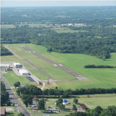
| CITY ORDINANCE MANDATES ALL TAKE-OFFS ON RY 34 COMMENCE AT THLD MARKINGS. HIGH SPEED, LOW LEVEL PASSES ARE PROHIBITED. |
| WINDSOCK NOT VISIBLE FROM RWY 16 END. |
| FOR CD CTC FORT WORTH ARTCC AT 817-858-7584. |
| TWY MKGS & HOLD SHORT LINES POOR. HOLD LINE SIGNS NSTD WHITE. |
Airport Communications & Frequencies:
| |||||||||
| Runway: 16 | Runway: 34 | ||
| Mag heading: | 163° | Mag heading: | 343° |
| Rwy Slope: | -.85% Down | Rwy Slope: | .85% Up |
| Approach: | Approach: | ||
| Pattern: | Left Traffic | Pattern: | Left Traffic |
| Markings: | NONPRECISION INSTRUMENT | Markings: | NONPRECISION INSTRUMENT |
| Marking Condition: | GOOD | Marking Condition: | GOOD |
| Arresting Dev: | Arresting Dev: | ||
| Lat & Long: | N3337.8 W09635.3 | Lat. & Long.: | N3337.1 W09635.1 |
| Elev: | 746.0 ft. MSL | Elev: | 711.9 ft. MSL |
| TCH: | TCH: | ||
| Visual Glide Path: | Visual Glide Path: | ||
| Displaced Threshold: | No | Displaced Threshold: | No |
| Touchdown Zone: | YES | Touchdown Zone: | YES |
| Touchdown Elev.: | 746.1 feet | Touchdown Elev.: | 738.7 feet |
| Visual Glide Slope: | Visual Glide Slope: | ||
| RVR Equipment: | RVR Equipment: | ||
| RVV Equipment: | NO | RVV Equipment: | NO |
| Approach Lights: | Approach Lights: | ||
| REIL: | NO | REIL: | NO |
| Centerline Lights: | NO | Centerline Lights: | NO |
| Touchdown lights: | NO | Touchdown lights: | NO |
| Runway Category: | Runway with a Non-precision Approach having visibility minimums greater than 3/4 mile | Runway Category: | Runway with a Non-precision Approach having visibility minimums greater than 3/4 mile |
| Declared Distances: | Declared Distances: | ||
| Obstructions: | TREES | Obstructions: | PLINE |
| Marked: | NOT Marked/Lighted | Marked: | NOT Marked/Lighted |
| Clearance slope: | 10:1 | Clearance slope: | 34:1 |
| Obstruction height: | 30 feet AGL | Obstruction height: | 14 feet AGL |
| Dist. from runway: | 530 feet | Dist. from runway: | 700 feet |
| Centerline offset: | 250 right of centerline | Centerline offset: | |
| Comments: | 20 FT TREES, 0-199 FT DSTC, 220 R. | Comments: | 30 FT TREES, 0-199 FT DSTC, 220 FT L. |
