
| ||||||||||||||||||||||||||||||||||||||||||||||||||||||||||||||||||||
| ||||||||||||||||||||||||||||||||||||||||||||||||||||||||||||||||||||
| ||||||||||||||||||||||||||||||||||||||||||||||||||||||||||||||||||||
| ||||||||||||||||||||||||||||||||||||||||||||||||||||||||||||||||||||
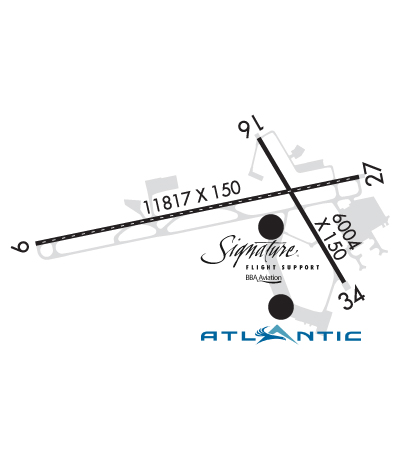
| Rwy | Rwy | |||||||
| 11817x150 | 9817' | 110.10 - 092° | 11817x150 | 9817' | 109.95 - 272° | |||
| 6004x150 | 6004' | 6004x150 | 6004' | |||||
| Runway ID | Single Wheel | Double Wheel | Double Tandem Wheel | Dual Double Wheel |
| 09/27 | 85,000 | 175,000 | 350,000 | 775,000 |
| 16/34 | 120,000 | 190,000 | 350,000 | 800,000 |
| H1 | N/A | N/A | N/A | N/A |
| These numbers are Advisory and are not limits. The Airport Manager should have more accurate Weight Limits | ||||
 Airport Diagram might not be current. | |
| Facility Name: | NEW YORK STEWART INTL |
| City Name: | NEW YORK |
| County: | ORANGE |
| State abbrev: | NY |
| State Name: | NEW YORK |
| Ownership: | PUBLICLY OWNED |
| Use: | OPEN TO THE PUBLIC |
| Owner's Name: | PORT AUTHORITY OF NY & NJ; LEASEE PANYNJ; . PROPERTY OWNED BY NYSDOT 1220 WASHINGTON AVE. ALBANY, NY 12226. TELEPHONE 518-457-2822. |
| Address: | 1180 FIRST ST |
| NEW WINDSOR, NY 12553 | |
| Owner's Phone: | 845-838-8200 |
| Manager's Name: | OMAR ASTACIO |
| Address: | 1180 FIRST ST |
| NEW WINDSOR, NY 12553 | |
| Phone: | 845-838-8200 |
| FAA Region: | EASTERN |
| FAA Field Office: | NYC |

| Date | Sunrise | Sunset |
|---|---|---|
| 04/18/24 Thursday | 6:11 | 19:41 |
| 04/19/24 Friday | 6:09 | 19:42 |
| 04/20/24 Saturday | 6:08 | 19:43 |
| 04/21/24 Sunday | 6:06 | 19:44 |
| 04/22/24 Monday | 6:05 | 19:45 |
| 04/23/24 Tuesday | 6:03 | 19:46 |
| 04/24/24 Wednesday | 6:02 | 19:47 |
| 04/25/24 Thursday | 6:01 | 19:49 |
| 04/26/24 Friday | 5:59 | 19:50 |
| 04/27/24 Saturday | 5:58 | 19:51 |
| 04/28/24 Sunday | 5:56 | 19:52 |
| 04/29/24 Monday | 5:55 | 19:53 |
| 04/30/24 Tuesday | 5:54 | 19:54 |
| 05/01/24 Wednesday | 5:52 | 19:55 |
| Airport Attendance Schedule | CONTINUOUS |
| Airport Status | OPERATIONAL (This Status can change at any time - please check NOTAMS) |
| Airport Lighting Schedule | |
| Airport Storage Available | NONE |
| Extra Services Available | Cargo Handling, Charter, Flight Instruction, Aircraft Rental |
| Wind Indicator | YES - (lighted) |
| Control Tower | YES |
| CTAF Frequency | |
| Unicom Frequency | 122.950 |
| Rotating Beacon Color | WG |
| Segmented Circle | NO |
| Landing Fee | NO; FEE FOR ACFT $1.53 PER 1000 LBS. CERTIFICATED GROSS MAXIMUM TAKEOFF WEIGHT. |
| Airport Inspected | FEDERAL - performed by FAA AIRPORTS FIELD PERSONNEL |
| Inspection Date | 05/30/2023 |
| Type of Fuel Available | Grade 100LL, JET A (freeze point -40C) |
| Airframe Repair Service | MAJOR |
| Power Plant Repair Service | MAJOR |
| Latitude | N4130.2 |
| Longitude | W07406.3 (ESTIMATED) |
| Arpt Elevation | 490ft (SURVEYED) |
| Magnetic Variation | 14W |
| 44 miles N | of NEW YORK |
| Traffic Pattern Altitude | 709; TPA: 709 FT AGL HEL, 1009 FT AGL RECIPROCATING ENG, 2009 FT AGL TURBOPROP/JET. |
| Sectional Chart | NEW YORK |
| Operations (Reported) | Yearly | Avg. Daily |
|---|---|---|
| General Aviation Transient | 15827 | 43 |
| General Aviation Local | 6714 | 18 |
| Air Taxi | 3313 | 9 |
| Commerical | 3499 | 10 |
| Commuter | 0 | 0 |
| Military | 5225 | 14 |
| Aircraft based on Field | |
|---|---|
| General Aviation Singles | 7 |
| General Aviation Multi | 3 |
| Jet Aircraft | 32 |
| General Aviation Helicopters | 7 |
| Military Aircraft | 11 |
| Gliders | 0 |
| Ultralights | 0 |
| FSS on field | NO |
| FSS tie-in | NEW YORK |
| FSS Phone | 1-800-WX-BRIEF |
| Who issues Notams | SWF |
| Notam D service at airport | YES |
| ARTCC Name | NEW YORK |
| Airport Certification | AIRPORT RECEIVING SCHEDULED AIR CARRIER SERVICE FROM CARRIERS CERTIFICATED BY THE CIVIL AERONAUTICS BOARD |
| Aircraft Rescue & Firefighting Index | AIRPORT HAS A CERTIFICATE UNDER CFR PART 139 |
| Airport of Entry | No |
| Custom Landing Rights | No; US CUSTOMS USER FEE ARPT. |
| Joint Civil/Military | No |
| Military Landing rights | YES |
| NATIONAL PLAN OF INTEGRATED AIRPORT SYSTEMS (NPIAS) |
| GRANT AGREEMENTS UNDER FAAP/ADAP/AIP |
| SURPLUS PROPERTY AGREEMENT UNDER PUBLIC LAW 289 |
| ASSURANCES PURSUANT TO TITLE VI, CIVIL RIGHTS ACT OF 1964 |
| AVOID ORANGE COUNTY ARPT LCTD 7 NM WNW DURG VFR APCHS. |
| NOISE ABATEMENT PROCEDURES IN EFFECT CTC AMGR 845-838-8200. |
| RGT TFC ON RYS 16 & 27 MAY BE USED FOR NOISE ABATEMENT. |
| USER FEE CHARGED TO ALL INTL FLIGHTS. |
| COMPASS CALIBRATION PAD LCTD ON THE TY 'G' RUNUP APRON. |
| TWYS 'B' & 'H' RESTRICTED TO ACFT WITH WINGSPAN GREATER THAN 118'. |
| TWY 'C' RESTRICTED TO ACFT WITH WINGSPAN GREATER THAN 125 FT BTN TERMINAL BLDG & BLDG 118. |
| ACFT WITH WINGSPAN 172 FT OR MORE RQR VEHICLE ESCORT FOR ALL TWY 'C' OPNS SOUTH OF TERMINAL APRON. CTC ARPT OPNS 845-838-8237. |
| MILITARY: ARMY OPS 1300-2100Z++ WEEKDAYS EXC HOL, C845-567-1209, O CTC FBO. 24 HR PPR ONLY FOR PARKING ARMY RAMP. NO SVC AVAIL THROUGH ARMY RAMP, CTC FBO. 48 HR PPR ALL OPERATIONS ON WEST POINT MILITARY RESERVATION, CTC USMA G-3, C845-938-2011, C845-938-3424. |
| MILITARY: ALL MIL ACFT OPR, BASH PHASE II PERIOD (1 APR-30 MAY & 1 AUG-30 NOV) BIRD WATCH COND SEVERE (TKOF AND LDGS PROH UNLESS GREATER EMERG AND/OR IMMED OPERATIONAL NECESSITY EXISTS. LCL AND TACTICAL TRNG PROH) MODERATE (MULTIPLE APCHS PROH A DEPARTURE AND FULL STOP ALLOWED IF RTE AVOIDS BIRDS ACT.) |
| MILITARY: AFLD MGR DOES NOT ISSUE OR STORE COMSEC FOR TRAN CREWS. TMPRY STOR OF CLASSIFIED MATERIALS UP TO SECRET AT COMD POST. |
| TWY 'C' BTN TWY 'B' & TWY 'F' NOT VISIBLE FM TWR. |
| TWY L CLSD EXC 20 MIN PPR. TWY L APRON FOLLOW ME VEHICLE REQUIRED. CTC ARPT OPNS 845-838-8237. |
| BIRDS & DEER ON & INVOF ARPT. |
| FUELL: A++ AVAILABLE. |
| MILITARY: ADVSY FOR TRAN AIRCREW - NSTD WHITE VEH PARKING BOXES AND C-17 WING-TIP GUIDE LINES PAINTED ON ANG RAMP. |
| MILITARY: COMD POST OPR 1000-0400++, DSN 636-2286. |
| ALL SURFACES. WORKNIN PROGRESS GRASS CUTTING CONDUCTED APRIL THROUGH OCTOBER. |
| NO JET TRNG 2300 TO 0700 DLY. |
| HUDSON VALLEY RGNL LCTD 3.3 NM SW IGN VORTAC; DO NOT MISTAKE FOR STEWART INTL. |
| BE AWARE - EXTENSIVE GLIDER ACTVTY 8 MI EAST OF HUO VORTAC IN A 5-MI RADIUS. |
| RWY H1 HELIPAD LCTD INTXN TWYS B & C EAST OF TWY C. |
Airport Communications & Frequencies:
| ||||||||||||||||||||||||||||
| Runway: 09 | Runway: 27 | ||
| Mag heading: | 92° | Mag heading: | 272° |
| Rwy Slope: | -.20% Down | Rwy Slope: | .20% Up |
| Approach: | ILS | Approach: | ILS/DME |
| Pattern: | Left Traffic | Pattern: | Left Traffic |
| Markings: | PRECISION INSTRUMENT | Markings: | PRECISION INSTRUMENT |
| Marking Condition: | GOOD | Marking Condition: | GOOD |
| Arresting Dev: | Arresting Dev: | ||
| Lat & Long: | N4130.1 W07407.8 | Lat. & Long.: | N4130.4 W07405.3 |
| Elev: | 490.7 ft. MSL | Elev: | 466.6 ft. MSL |
| TCH: | 65 ft. AGL | TCH: | 56 ft. AGL |
| Visual Glide Path: | 3.00 degrees | Visual Glide Path: | 3.00 degrees |
| Displaced Threshold: | 2000 feet | Displaced Threshold: | 2000 feet |
| Touchdown Zone: | YES | Touchdown Zone: | YES |
| Touchdown Elev.: | 482.1 feet | Touchdown Elev.: | 468.5 feet |
| Visual Glide Slope: | 4-Light PAPI on LEFT side of Runway | Visual Glide Slope: | 4-Light PAPI on LEFT side of Runway |
| RVR Equipment: | TOUCHDOWN-MIDFIELD-ROLLOUT | RVR Equipment: | TOUCHDOWN-MIDFIELD-ROLLOUT |
| RVV Equipment: | NO | RVV Equipment: | NO |
| Approach Lights: | ALSF2 - standard 2,400 foot high intensity approach lighting system with sequenced flashers, Category II or III | Approach Lights: | |
| REIL: | NO | REIL: | YES |
| Centerline Lights: | YES | Centerline Lights: | YES |
| Touchdown lights: | YES | Touchdown lights: | NO |
| Runway Category: | Precision Instrument Runway | Runway Category: | Precision Instrument Runway |
| Declared Distances: | TORA:11817' TODA:11817' ASDA:10817' LDA:8817' | Declared Distances: | TORA:11817' TODA:11817' ASDA:11817' LDA:9817' |
| Obstructions: | FENCE | Obstructions: | TREE |
| Marked: | LIGHTED | Marked: | NOT Marked/Lighted |
| Clearance slope: | 5:1; RWY 9 APCH SLOPE 50:1 TO DSPLCD THLD. | Clearance slope: | 13:1; RWY 27 APCH SLOPE 46:1 TO DSPLCD THLD. |
| Obstruction height: | 38 feet AGL | Obstruction height: | 67 feet AGL |
| Dist. from runway: | 420 feet | Dist. from runway: | 1120 feet |
| Centerline offset: | 550 right of centerline | Centerline offset: | 140 feet right of centerline |
| Comments: | Comments: |
| Runway: 16 | Runway: 34 | ||
| Mag heading: | 163° | Mag heading: | 343° |
| Rwy Slope: | -.56% Down | Rwy Slope: | .56% Up |
| Approach: | Approach: | ||
| Pattern: | Left Traffic | Pattern: | Left Traffic |
| Markings: | NONSTANDARD | Markings: | NONSTANDARD |
| Marking Condition: | GOOD; RY 16 HAS MILITARY ASSAULT LANDING ZONE & BASIC MKGS WITH AIMING POINTS. | Marking Condition: | GOOD; RY 34 HAS MILITARY ASSAULT LANDING ZONE & BASIC MKGS WITH AIMING POINTS. |
| Arresting Dev: | Arresting Dev: | ||
| Lat & Long: | N4130.7 W07406.1 | Lat. & Long.: | N4129.8 W07405.4 |
| Elev: | 471.3 ft. MSL | Elev: | 437.4 ft. MSL |
| TCH: | 53 ft. AGL | TCH: | 49 ft. AGL |
| Visual Glide Path: | 3.00 degrees | Visual Glide Path: | 3.00 degrees |
| Displaced Threshold: | No | Displaced Threshold: | No |
| Touchdown Zone: | YES | Touchdown Zone: | YES |
| Touchdown Elev.: | 471.4 feet | Touchdown Elev.: | 461.8 feet |
| Visual Glide Slope: | 4-Light PAPI on LEFT side of Runway; PAPI UNUSBL BYD 5 DEGS LEFT OF CNTRLN. | Visual Glide Slope: | 4-Light PAPI on LEFT side of Runway |
| RVR Equipment: | RVR Equipment: | ||
| RVV Equipment: | NO | RVV Equipment: | NO |
| Approach Lights: | Approach Lights: | ||
| REIL: | YES | REIL: | YES |
| Centerline Lights: | NO | Centerline Lights: | NO |
| Touchdown lights: | NO | Touchdown lights: | NO |
| Runway Category: | Runway with a Non-precision Approach having visibility minimums greater than 3/4 mile | Runway Category: | Runway with a Non-precision Approach having visibility minimums greater than 3/4 mile |
| Declared Distances: | TORA:6004' TODA:6004' ASDA:6004' LDA:6004' | Declared Distances: | TORA:6004' TODA:6004' ASDA:6004' LDA:6004' |
| Obstructions: | Obstructions: | TREES | |
| Marked: | Marked: | NOT Marked/Lighted | |
| Clearance slope: | 34:1 | Clearance slope: | 34:1 |
| Obstruction height: | Obstruction height: | 17 feet AGL | |
| Dist. from runway: | Dist. from runway: | 780 feet | |
| Centerline offset: | Centerline offset: | 220 feet right of centerline | |
| Comments: | RWY 16 +3 FT GROUND 140 FT FM RY END 240 FT L. | Comments: |


