KSUX

SIOUX GATEWAY/COL. BUD DAY FIE
SIOUX CITY
IA
Time Zone: Central
Lat: N 4224.1
Long: W 09623.1
Elev: 1098
Var: -03
Longest Runway: 9002
Dept. ATIS: 119.45
Arr. ATIS: 119.45
AWOS: 119.45
Ground: 121.9
Tower: 118.7

FBO & Flight Services info for KSUX

FBOs: Update your Fuel Prices
Above all, the Oracle Team is here to support you. Our Customer Service staff is ready to help with any logistical needs for passengers and crew. Let Oracle assist with your trip planning, and we92llnsure that your needs are met and expectations exceeded.
Ph: 712-226-5387
-
Freq: 122.95WebsiteE-Mail
                          
Service
Jet
100LL
SAF
MoGas
Full        Last Update: 04/09/2024 13:07

Self        
Misc. Info: Address: 5701 AL HAYNES DRIVE,   SIOUX CITY, IA 51111

HAWTHORNE GLOBALPh: 712-258-6563 Fax: 712-258-7584 Freq: 122.95
Service
Jet
100LL
SAF
MoGas
Fuel Avail: Operating Hours 0600 - 2200 Mon - Fri, 0600-2100 Sat - Sun hours call-out is available
Full6.996.94    Last Update: 04/22/2024 16:30  
Self        
 Address: 5815 MITCHELL,   SIOUX CITY, IA 51111
ASOSPh: 712-255-6474
-
Freq: 119.45  
If you are an FBO, call 1-203-262-1700 to update your info or email: FltPlan.Advertising@garmin.com
Advertise your FBO on FltPlan.com
FBOs at nearby airports who want your business:
KFSD


  click here  
Maverick Air Center at KFSD

- Open 24/7
- No Ramp Fees, No Security Fees, No Handling Fees, No Additive Fees!
- Providing Excellent Service at competitive rates
- Quick Turns
- Jet A & 100LL
- Walk-up rental vehicles
- Large hangar space, able to accomodate a G550

www.maverickaircenter.com
Ph: 1-605-312-5680WebsiteE-MailFax: 1-605-271-6387Freq: 122.77

Runway & Approach Info for KSUX
Rwy
Length
Land Dist**
Approach*
  Rwy
Length
Land Dist**
Approach*
13
9002x150  9002'          
ILS
 111.30 - 132°  
  
31
  9002x150  9002'          
ILS/DME
 109.30 - 312°  
18
6401x100  6401'          
 
  
36
  6401x100  6401'          
 
 * only ILS, LOC, LDA, and SDF approaches to a specific runway are shown
** For any Declared Landing Distance Available, please see A/FD or Approach plates
Runway Weight Capability (lbs.) Help
Runway IDSingle WheelDouble WheelDouble Tandem WheelDual Double Wheel
13/31100,000120,000220,000N/A
18/3665,00080,000130,000N/A
These numbers are Advisory and are not limits.   The Airport Manager should have more accurate Weight Limits
Approach Charts
Approaches    
Current Weather/Notams
Customs Information Send updates to Support@FltPlan.com
Customs Not Available
Database effective 05/16/2024
Airport Diagram of KSUX
Airport Diagram might not be current.

Facility Name: SIOUX GATEWAY/BRIG GENERAL BUD DAY FLD
City Name: SIOUX CITY
County: WOODBURY
State abbrev: IA
State Name: IOWA
   
Ownership: PUBLICLY OWNED
Use: OPEN TO THE PUBLIC
Owner's Name: SIOUX GATEWAY AIRPORT
Address: 2403 AVIATION BLVD.
 SIOUX CITY, IA 51111
Owner's Phone: 712-279-0167
  
Manager's Name: MR. ALVIN LORENZO
Address: 2403 AVIATION BLVD.
 SIOUX CITY, IA 51111
Phone: 720-365-6312
   
FAA Region: CENTRAL
FAA Field Office: NONE
September 2007 - Photo courtesy of Marion Cain


Click here for full scale & interactive Sectional view of KSUX


Sunrise / Sunset times for SIOUX GATEWAY/BRIG GENERAL BUD DAY FLD

DateSunriseSunset
04/24/24 Wednesday6:2920:18
04/25/24 Thursday6:2820:19
04/26/24 Friday6:2720:21
04/27/24 Saturday6:2520:22
04/28/24 Sunday6:2420:23
04/29/24 Monday6:2220:24
04/30/24 Tuesday6:2120:25
05/01/24 Wednesday6:2020:26
05/02/24 Thursday6:1820:27
05/03/24 Friday6:1720:28
05/04/24 Saturday6:1620:29
05/05/24 Sunday6:1420:31
05/06/24 Monday6:1320:32
05/07/24 Tuesday6:1220:33

Airport Facilities

Airport Attendance ScheduleMON-SUN 0500-2200
Airport Status OPERATIONAL (This Status can change at any time - please check NOTAMS)
Airport Lighting ScheduleDUSK-DAWN. WHEN ATCT CLSD ACTVT MALS RWY 13; MALSR RWY 31; REIL RWY 18; VASI RWY 13 & 31; HIRL RWY 13/31; MIRL RWY 18/36 - CTAF.
Airport Storage AvailableTie Downs, Hanger
Extra Services AvailableAir Freight, Air Ambulance, Charter, Flight Instruction, Aircraft Rental, Aircraft Sales, Annual Surveying
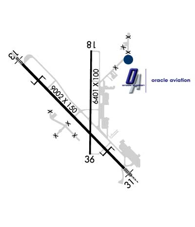
Wind IndicatorYES - (lighted)
Control TowerYES
CTAF Frequency118.700
Unicom Frequency122.950
Rotating Beacon ColorWG
Segmented CircleNO
Landing FeeNO

Airport Inspection Data

Airport InspectedFEDERAL - performed by FAA AIRPORTS FIELD PERSONNEL
Inspection Date06/21/2023

Airport Services

Type of Fuel AvailableGrade 100LL, JET A (freeze point -40C); -A FOR FUEL AND SUPPORT AFT HRS BY PPR OR CALL IN.
Airframe Repair ServiceMAJOR
Power Plant Repair ServiceMAJOR

Geographic Data

LatitudeN4224.1
LongitudeW09623.1 (ESTIMATED)
Arpt Elevation1098ft (SURVEYED)
Magnetic Variation03E
6 miles Sof SIOUX CITY
Traffic Pattern Altitude
Sectional ChartOMAHA

Aircraft Data

Operations (Reported)YearlyAvg. Daily
General Aviation Transient 798222
General Aviation Local 20005
Air Taxi 27838
Commerical 18255
Commuter 00
Military 491913
Aircraft based on Field
General Aviation Singles 41
General Aviation Multi 3
Jet Aircraft 11
General Aviation Helicopters 2
Military Aircraft 9
Gliders 0
Ultralights 0

FAA Services

FSS on field NO
FSS tie-in FORT DODGE
FSS Phone 1-800-WX-BRIEF
Who issues Notams SUX
Notam D service at airport YES
ARTCC Name MINNEAPOLIS

Federal Status

Airport CertificationAIRPORT RECEIVING SCHEDULED AIR CARRIER SERVICE FROM CARRIERS CERTIFICATED BY THE CIVIL AERONAUTICS BOARD; ARFF INDEX E FIRE FIGHTING EQUIPTMENT AVBL ON REQUEST.
Aircraft Rescue & Firefighting IndexAIRPORT HAS A CERTIFICATE UNDER CFR PART 139
Airport of EntryNo
Custom Landing RightsNo
Joint Civil/MilitaryNo
Military Landing rightsYES

Federal Agreements

NATIONAL PLAN OF INTEGRATED AIRPORT SYSTEMS (NPIAS)
GRANT AGREEMENTS UNDER FAAP/ADAP/AIP
SURPLUS PROPERTY AGREEMENT UNDER PUBLIC LAW 289
ASSURANCES PURSUANT TO TITLE VI, CIVIL RIGHTS ACT OF 1964

Remarks

(E60-13) BAK12/14 LCTD 1392' FROM THR.
PAEW 2130-0600 DURING INCLEMENT WEATHER NOV-APR.
CTN: OCNL BIRDWATCH COND - SEV DRG SPRING/FALL DUE TO MIGRATORY WATERFOWL. CIVILIAN TWR DOES NOT BROADCAST USAF BIRDWATCH COND. CTC AFLD MGMT FOR BIRD STS.
RY 31 IS CALM WIND RY.
SERVICE-FLUID: LPOX & LHNIT.
SERVICE-JASU: 6(A/M32A-86) 6(A/M32-95).
APCH END RWY 31 - BAK-12(B)/14 LCTD (1492').
AFLD SURFACE CONDITIONS NOT MONITORED BY ARPT MANAGEMENT BTN 0000 - 0400 LCL DAILY.
RSTD: ALL MIL OPS OPR 1300-2200Z++ TUE-FRI EXC HOL.
SERVICE-OIL: JOAP- AVBL ONLY DUR ANG DUTY HR.
CAUTION: PORTIONS OF TWY A SE OF TWY B NOT VIS BY TWR.
FUEL: A++
ATCT HAS LIMITED VISIBILITY OF TWY A NEAR ARFF BLDG AND OF TWY G.
FOR CD IF UNA TO CTC ON FSS FREQ, CTC MINNEAPOLIS ARTCC AT 651-463-5588.
APCH END RY 13 - BAK-12/14(B) LCTD(1500').
PPR FOR USE OF ANG RAMP V(712)-233-0210.
ANG RMRKS: OFFL BUS ONLY/PPR. COMMAND POST (24 HR OPN) DSN 585-0211 OR 585-0212 OR C712-233-0211/0212. EXTREMELY LIMITED PARKING. TRANS ACFT PAX IDENT & BAGGAGE SEARCH UNAVBL.BASE OPS OPR 1230-2230Z++ TUE-FRI EXC HOL. C712-233-0276 DSN 585-0276.
Airport Communications & Frequencies:
ATIS Frequencies:   Hours(local) of Operation: CONTINUOUS
119.45
270.8
SIOUX CITY Tower Frequencies:   Hours(local) of operation: 0600-2130   
118.7
254.3
SIOUX CITY Ground Frequencies:
121.9
348.6
Emergency Frequencies:
121.5
CTAF Frequency:
118.700
Unicom Frequency:
122.950
Remarks
  • APCH/DEP SVC PRVDD BY MINNEAPOLIS ARTCC ON FREQS 125.025/235.625 WHEN APCH CTL CLSD (SIOUX CITY RCAG).
  • SIOUX CITY Primary Approach Frequencies:   Hours(local) of operation: 0600-2130   
    124.6
    307.0
    SIOUX CITY Primary Departure Frequencies:   Hours(local) of operation: 0600-2130   
    124.6
    307.0
    Runway Identifications
    Runway Identification: 13/31
    Length: 9002 ft
    Width: 150 ft
    Surface: CONCRETE-GOOD CONDITION
    Edge lights: High Intensity

    Treatment: GROOVED
    Weight: PCN 51 /R/B/W/T

     Runway: 13   Runway: 31
    Mag heading: 133°Mag heading: 313°
    Rwy Slope: .00% UpRwy Slope: .00% Down
    Approach: ILSApproach: ILS/DME
    Pattern: Left TrafficPattern: Left Traffic
    Markings: PRECISION INSTRUMENTMarkings: PRECISION INSTRUMENT
    Marking Condition: GOODMarking Condition: GOOD
    Arresting Dev: BAK-12; BAK-14 BAK-12B(B) (1392').Arresting Dev: BAK-12; BAK-14 BAK-12B(B) (1492').
    Lat & Long: N4224.6  W09623.9Lat. & Long.: N4223.5  W09622.5
    Elev: 1093.1 ft. MSLElev: 1093.3 ft. MSL
    TCH: 50 ft. AGLTCH: 55 ft. AGL
    Visual Glide Path: 3.00 degreesVisual Glide Path: 3.00 degrees
    Displaced Threshold: NoDisplaced Threshold: No
    Touchdown Zone: YESTouchdown Zone: YES
    Touchdown Elev.: 1094.6 feetTouchdown Elev.: 1096.4 feet
    Visual Glide Slope: 4-BOX VASI ON LEFT SIDE OF RUNWAYVisual Glide Slope: 4-BOX VASI ON LEFT SIDE OF RUNWAY
    RVR Equipment: TOUCHDOWN-ROLLOUTRVR Equipment: TOUCHDOWN-ROLLOUT
    RVV Equipment: NORVV Equipment: NO
    Approach Lights: MALS - 1,400 foot medium intensity approach lighting systemApproach Lights: MALSR - 1,400 foot medium intensity approach lighting system with runway alignment indicator lights
    REIL: NOREIL: NO
    Centerline Lights: NOCenterline Lights: NO
    Touchdown lights: NOTouchdown lights: NO
    Runway Category: Precision Instrument RunwayRunway Category: Precision Instrument Runway
    Declared Distances: TORA:9002' TODA:9002' ASDA:9002' LDA:9002'Declared Distances: TORA:9002' TODA:9002' ASDA:9002' LDA:9002'
    Obstructions: TREEObstructions:
    Marked: NOT Marked/LightedMarked:
    Clearance slope: 40:1Clearance slope: 50:1
    Obstruction height: 72 feet AGLObstruction height:
    Dist. from runway: 3100 feetDist. from runway:
    Centerline offset: 475 left of centerlineCenterline offset:
    Comments: Comments:
    Runway Identification: 18/36
    Length: 6401 ft
    Width: 100 ft
    Surface: ASPHALT-FAIR CONDITION
    Edge lights: Medium Intensity

    Treatment: GROOVED
    Weight: PCN 31 /F/D/X/T

     Runway: 18   Runway: 36
    Mag heading: 178°Mag heading: 358°
    Rwy Slope: -.04% DownRwy Slope: .04% Up
    Approach: Approach:
    Pattern: Left TrafficPattern: Left Traffic
    Markings: NONPRECISION INSTRUMENTMarkings: NONPRECISION INSTRUMENT
    Marking Condition: FAIRMarking Condition: FAIR
    Arresting Dev: Arresting Dev:
    Lat & Long: N4224.7  W09622.9Lat. & Long.: N4223.6  W09622.9
    Elev: 1097.6 ft. MSLElev: 1095.3 ft. MSL
    TCH: 54 ft. AGLTCH: 54 ft. AGL
    Visual Glide Path: 3.00 degreesVisual Glide Path: 3.00 degrees
    Displaced Threshold: NoDisplaced Threshold: No
    Touchdown Zone: YESTouchdown Zone: YES
    Touchdown Elev.: 1098.4 feetTouchdown Elev.: 1096.9 feet
    Visual Glide Slope: 4-Light PAPI on RIGHT side of RunwayVisual Glide Slope: 4-Light PAPI on LEFT side of Runway
    RVR Equipment: RVR Equipment:
    RVV Equipment: NORVV Equipment: NO
    Approach Lights: Approach Lights:
    REIL: YESREIL: NO
    Centerline Lights: NOCenterline Lights: NO
    Touchdown lights: NOTouchdown lights: NO
    Runway Category: Runway with a Non-precision Approach having visibility minimums greater than 3/4 mileRunway Category: Runway with a Non-precision Approach having visibility minimums greater than 3/4 mile
    Declared Distances: TORA:6400' TODA:6400' ASDA:6400' LDA:6400'Declared Distances: TORA:6400' TODA:6400' ASDA:6400' LDA:6400'
    Obstructions: TREESObstructions: POLE
    Marked: NOT Marked/LightedMarked: NOT Marked/Lighted
    Clearance slope: 20:1Clearance slope: 43:1
    Obstruction height: 47 feet AGLObstruction height: 16 feet AGL
    Dist. from runway: 1160 feetDist. from runway: 900 feet
    Centerline offset: 350 right of centerlineCenterline offset:
    Comments: Comments:
    C:48/P: