Global Access   -  Charter, Aircraft Management, Maintenance, Avionics and Aircraft Sales

KSUS

SPIRIT OF ST LOUIS
ST LOUIS
MO
Time Zone: Central
Lat: N 3839.7
Long: W 09039.1
Elev: 463
Var: +01
Longest Runway: 7485
Clr Del: 133.1
Dept. ATIS: 134.8
Arr. ATIS: 134.8
Ground: 121.7
Tower: 124.75

FBO & Flight Services info for KSUS

FBOs: Update your Fuel Prices
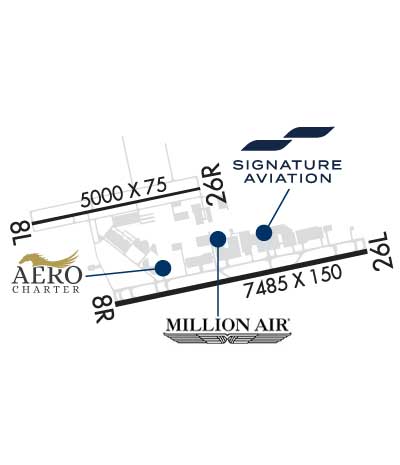
Land at any FBO in our growing worldwide network and you'll receive a warm, friendly Signature greeting. Consistent, exceptional service. Line support that's expert, safe and ready on the ramp. Clean, comfortable, well-furnished facilities. Service professionals who go the extra mile for your passengers and crew. Competitive pricing in every market.
Ph: 636-532-8882 Fax: 636-532-9061 Freq: 131.32WebsiteE-Mail
                     
Service
Jet
100LL
SAF
MoGas
Fuel Avail: 24/7
Full6.717.43    Last Update: 04/24/2024 09:41
PRICES GUARANTEED by FBO.
Self  5.78    
Misc. Info: Address: 18260 EDISON AVE,   CHESTERFIELD, MO 63005

  click here  
Aero Charter has operated jet and piston aircraft for more than 40 years and we know FBOs. We have traveled the world in search of the finest FBO practices and now we want to show you that we are the best. No matter if you are flying a Gulfstream 650 or a J3 Cub, we are excited to serve you!
Ph: 636-449-5150 Fax: 636-449-5170 Freq: 130.95WebsiteE-Mail
                   
Service
Jet
100LL
SAF
MoGas
Fuel Avail: 24/7
Full5.586.61    Last Update: 04/17/2024 19:35
PRICES GUARANTEED by FBO. *
*Posted Price is Guaranteed Current
Self        
Misc. Info: Fuel quantity discounts available for purchases over 150 gallons, call for details!Address: 501 TURBINE AVENUE,   CHESTERFIELD, MO 63005-3630

  click here  
Avgas and Jet-A Fuel, Pilot and Customer Lounge with high speed wireless internet, Complimentary Crew Cars, Rental Cars On-Site,and the only FBO on the field with our own fleet of Rental Cars. Conference Room, Catering, Gourmet Coffee Bar, Overnight Hangar Space and Tie-Downs, and cookies baked daily.
Ph: 866-532-0408 Fax: 636-532-7901 Freq: 130.30WebsiteE-Mail
                     
Service
Jet
100LL
SAF
MoGas
Fuel Avail: 24/7. PRIST PREMIXED
Full6.187.55    Last Update: 03/26/2024 14:19

Please call
Self        
Misc. Info: Proud to be a CAA preferred FBO.Address: 549 BELL AVE,   CHESTERFIELD, MO 63005-3602

ATISPh: 636-532-3213
-
Freq: 134.8  
ASOSPh: 636-536-3734
-
-
 
If you are an FBO, call 1-203-262-1700 to update your info or email: FltPlan.Advertising@garmin.com
Advertise your FBO on FltPlan.com

Runway & Approach Info for KSUS
Rwy
Length
Land Dist**
Approach*
  Rwy
Length
Land Dist**
Approach*
08L
5000x75  5000'          
 
  
26R
  5000x75  5000'          
 
08R
7485x150  7485'          
ILS
 110.55 - 079°  
  
26L
  7485x150  7004'          
ILS
 111.10 - 259°  
 * only ILS, LOC, LDA, and SDF approaches to a specific runway are shown
** For any Declared Landing Distance Available, please see A/FD or Approach plates
Runway Weight Capability (lbs.) Help
Runway IDSingle WheelDouble WheelDouble Tandem WheelDual Double Wheel
08L/26RN/AN/A45,500N/A
08R/26L33,000100,000N/AN/A
These numbers are Advisory and are not limits.   The Airport Manager should have more accurate Weight Limits
Approach Charts
https://flttrack.fltplan.com/arpt/KSUS_AeroCharter-FullService_468x60.jpgApproaches    
Current Weather/Notams
Customs Information Send updates to Support@FltPlan.com
Phone 636-536-1005
Fax 636-536-0580

Comments 2 hrs advance notice required. Business hrs 0830-1630 Monday-Friday. *Maximum passengers per flight: 30 *M-F Call prior to 1630 on preceding weekday *WKND Call prior to 1630 on preceding Friday
Database effective 05/16/2024
Airport Diagram of KSUS
Airport Diagram might not be current.

Facility Name: SPIRIT OF ST LOUIS
City Name: ST LOUIS
County: ST LOUIS
State abbrev: MO
State Name: MISSOURI
   
Ownership: PUBLICLY OWNED
Use: OPEN TO THE PUBLIC
Owner's Name: ST LOUIS COUNTY
Address: 18270 EDISON AVE NR 100
 CHESTERFIELD, MO 63005-3704
Owner's Phone: 636-532-2222
  
Manager's Name: MR. JOHN D. BALES
Address: SPIRIT OF ST LOUIS AIRPORT, EDISON AVE, NR 100
 CHESTERFIELD, MO 63005-3704
Phone: 636-532-2222
   
FAA Region: CENTRAL
FAA Field Office: NONE


Sunrise / Sunset times for SPIRIT OF ST LOUIS

DateSunriseSunset
04/23/24 Tuesday6:1419:48
04/24/24 Wednesday6:1319:49
04/25/24 Thursday6:1219:50
04/26/24 Friday6:1019:51
04/27/24 Saturday6:0919:52
04/28/24 Sunday6:0819:53
04/29/24 Monday6:0719:54
04/30/24 Tuesday6:0519:55
05/01/24 Wednesday6:0419:55
05/02/24 Thursday6:0319:56
05/03/24 Friday6:0219:57
05/04/24 Saturday6:0119:58
05/05/24 Sunday6:0019:59
05/06/24 Monday5:5920:00

Airport Facilities

Airport Attendance ScheduleCONTINUOUS
Airport Status OPERATIONAL (This Status can change at any time - please check NOTAMS)
Airport Lighting ScheduleATC-CTL. HIRL RY 08R/26L PRESET ON MED INTST 2300-0600; MIRL RY 08L/26R PRESET ON LOW INTST 2300-0600. TO INCR INTST AFT 2300 AND ACTVT MALSR RY 08R & 26L - CTAF.
Airport Storage AvailableTie Downs, Hanger
Extra Services AvailableAir Freight, Air Ambulance, Avionics, Charter, Flight Instruction, Aircraft Rental, Aircraft Sales, Annual Surveying
Wind IndicatorYES - (unlit)
Control TowerYES
CTAF Frequency124.750
Unicom Frequency122.950
Rotating Beacon ColorWG
Segmented CircleNO
Landing FeeNO

Airport Inspection Data

Airport InspectedSTATE - performed by FAA AIRPORTS FIELD PERSONNEL
Inspection Date02/14/2024

Airport Services

Type of Fuel AvailableGrade 100LL, JET A (freeze point -40C)
Airframe Repair ServiceMAJOR
Power Plant Repair ServiceMAJOR

Geographic Data

LatitudeN3839.7
LongitudeW09039.1 (ESTIMATED)
Arpt Elevation463ft (SURVEYED)
Magnetic Variation01W
17 miles Wof ST LOUIS
Traffic Pattern Altitude1273; TPA RWY 08R/26L PROP 1237 FT AGL, RWY 08L/26R PROP 837 FT AGL. TPA JETS 1537 FT AGL.
Sectional ChartST LOUIS

Aircraft Data

Operations (Reported)YearlyAvg. Daily
General Aviation Transient 56943156
General Aviation Local 77394212
Air Taxi 2001155
Commerical 1060
Commuter 00
Military 12894
Aircraft based on Field
General Aviation Singles 190
General Aviation Multi 40
Jet Aircraft 68
General Aviation Helicopters 7
Military Aircraft 0
Gliders 1
Ultralights 1

FAA Services

FSS on field NO
FSS tie-in SAINT LOUIS
FSS Phone 1-800-WX-BRIEF
Who issues Notams SUS
Notam D service at airport YES
ARTCC Name KANSAS CITY

Federal Status

Airport CertificationRWY 8L/26R NOT AVBL FOR SCHEDULED ACR OPNS WITH MORE THAN 9 PSGR SEATS OR UNSCHEDULED ACR AT LEAST 31 PSGR SEATS
Aircraft Rescue & Firefighting IndexAIRPORT HAS A CERTIFICATE UNDER CFR PART 139
Airport of EntryNo; FLIGHT NOTIFICATION SERVICE (ADCUS) AVBL 1700-0830 MON-FRI; 24 HRS SAT & SUN.
Custom Landing RightsYES
Joint Civil/MilitaryNo
Military Landing rightsYES

Federal Agreements

NATIONAL PLAN OF INTEGRATED AIRPORT SYSTEMS (NPIAS)
GRANT AGREEMENTS UNDER FAAP/ADAP/AIP
ASSURANCES PURSUANT TO TITLE VI, CIVIL RIGHTS ACT OF 1964

Remarks

THIS AIRPORT HAS BEEN SURVEYED BY THE NATIONAL GEODETIC SURVEY.
NMRS & INTS HEL OPS ON ARPT.
INT C CLSD INDEFLY BTWN TWY E & RWY 08L/26R.
NOISE ABATEMENT PROCS: FOR DEP STAGE III ACFT USE 08L/26R 2300-0600.
ALL MAINT-HI PWR ENG RUN-UPS USE GND RUN-UP ENCLOSURE ON TWY D.
ARPT CLSD TO ACFT OVER 100,000 LBS; EXCEPT ACFT 100,000-150,000 LBS FOR PPR 24 HRS CALL AMGR 636-532-1858.
NOISE ABATEMENT PROC IN EFCT: FOR DEP STAGE II ACFT USE RWY 08L/26R 2200-0700 EXCP PPR 636-532-2222 MON-FRI 0800-1700, OTR TIMES CALL 314-568-0581/0584, 636-536-2877, OR 636-441-9231.
TAXILANE B BTWN SOUTH ENTRANCE WEST RAMP AND TWY Z CLSD.
BRGT DRIVING RANGE LGTS 2.7 NM EAST OF RWY 26L.
24 HR PPR FOR ALL MIL ACFT, CTC 636-532-2222.
BE ALERT; NOISE SENSITIVE AREAS TO THE SOUTH OF ARPT.
TWY B BETWEEN SE & NW ENTRANCE TO WEST RAMP, TWY B NW TWY A FM THE DSTC OF 200 FT TO 700 FT & TWY Z NOT VSB BY TWR.
RWY 08L/ 26R& PARALLEL & CONNECTING TWY CLSD TO PART 121 ACR OPNS.
RWY 08R/ 26LRY 08R/26L CLSD TO TGL.
Airport Communications & Frequencies:
ATIS Frequencies:   Hours(local) of Operation: CONTINUOUS
134.8
SPIRIT Tower Frequencies:   Hours(local) of operation: 0600-2300   
124.75
257.2
SPIRIT Ground Frequencies:
121.7
Clearance Delivery Frequencies:
121.7 WHEN TWR CLSD
133.1
CTAF Frequency:
124.750
Unicom Frequency:
122.950
SAINT LOUIS Primary Approach Frequencies:  
126.5
254.3
SAINT LOUIS Primary Departure Frequencies:  
126.5
254.3
Runway Identifications
Runway Identification: 08L/26R
Length: 5000 ft
Width: 75 ft
Surface: ASPHALT-GOOD CONDITION
Edge lights: Medium Intensity

Treatment: RUBBERIZED FRICTION SEAL COAT
Weight: PCN 5 /F/D/X/T

 Runway: 08L   Runway: 26R
Mag heading: 79°Mag heading: 259°
Rwy Slope: .00% UpRwy Slope: .00% Down
Approach: Approach:
Pattern: Left TrafficPattern: Right Traffic
Markings: NONPRECISION INSTRUMENTMarkings: NONPRECISION INSTRUMENT
Marking Condition: GOODMarking Condition: GOOD
Arresting Dev: Arresting Dev:
Lat & Long: N3839.8  W09040.1Lat. & Long.: N3840.0  W09039.1
Elev: 463.0 ft. MSLElev: 463.1 ft. MSL
TCH: 41 ft. AGLTCH: 47 ft. AGL
Visual Glide Path: 3.00 degreesVisual Glide Path: 3.50 degrees
Displaced Threshold: NoDisplaced Threshold: No
Touchdown Zone: YESTouchdown Zone: YES
Touchdown Elev.: 463.2 feetTouchdown Elev.: 463.2 feet
Visual Glide Slope: 4-Light PAPI on LEFT side of RunwayVisual Glide Slope: 4-BOX VASI ON LEFT SIDE OF RUNWAY
RVR Equipment: RVR Equipment:
RVV Equipment: NORVV Equipment: NO
Approach Lights: Approach Lights:
REIL: NOREIL: NO
Centerline Lights: NOCenterline Lights: NO
Touchdown lights: NOTouchdown lights: NO
Runway Category: Runway with a Non-precision Approach having visibility minimums greater than 3/4 mileRunway Category: Runway with a Non-precision Approach having visibility minimums greater than 3/4 mile
Declared Distances: TORA:5000' TODA:5000' ASDA:5000' LDA:5000'Declared Distances: TORA:5000' TODA:5000' ASDA:5000' LDA:5000'
Obstructions: Obstructions: POLE
Marked: Marked: LIGHTED
Clearance slope: 50:1Clearance slope: 32:1
Obstruction height: Obstruction height: 31 feet AGL
Dist. from runway: Dist. from runway: 1200 feet
Centerline offset: Centerline offset: 150 feet right of centerline
Comments: Comments:
Runway Identification: 08R/26L
Length: 7485 ft
Width: 150 ft
Surface: CONCRETE-GOOD CONDITION
Edge lights: High Intensity

Treatment: GROOVED
Weight: PCN 34 /R/B/W/T

 Runway: 08R   Runway: 26L
Mag heading: 79°Mag heading: 259°
Rwy Slope: .01% UpRwy Slope: -.01% Down
Approach: ILSApproach: ILS
Pattern: Right TrafficPattern: Left Traffic
Markings: PRECISION INSTRUMENTMarkings: PRECISION INSTRUMENT
Marking Condition: GOODMarking Condition: GOOD
Arresting Dev: Arresting Dev:
Lat & Long: N3839.5  W09039.6Lat. & Long.: N3839.7  W09038.0
Elev: 461.3 ft. MSLElev: 461.9 ft. MSL
TCH: 55 ft. AGLTCH: 55 ft. AGL
Visual Glide Path: 3.00 degreesVisual Glide Path: 3.00 degrees
Displaced Threshold: NoDisplaced Threshold: 481 feet
Touchdown Zone: YESTouchdown Zone: YES
Touchdown Elev.: 461.9 feetTouchdown Elev.: 462.0 feet
Visual Glide Slope: 4-BOX VASI ON RIGHT SIDE OF RUNWAYVisual Glide Slope: 4-BOX VASI ON LEFT SIDE OF RUNWAY
RVR Equipment: TOUCHDOWNRVR Equipment: TOUCHDOWN
RVV Equipment: NORVV Equipment: NO
Approach Lights: MALSR - 1,400 foot medium intensity approach lighting system with runway alignment indicator lightsApproach Lights: MALSR - 1,400 foot medium intensity approach lighting system with runway alignment indicator lights
REIL: NOREIL: NO
Centerline Lights: YESCenterline Lights: YES
Touchdown lights: NOTouchdown lights: NO
Runway Category: Precision Instrument RunwayRunway Category: Precision Instrument Runway
Declared Distances: TORA:7485' TODA:7485' ASDA:7414' LDA:7414'Declared Distances: TORA:7485' TODA:7485' ASDA:7485' LDA:7004'
C:346/P: