Click here for more info on on SMS!

KSTS

CHARLES SCHULZ - SONOMA COUNTY
SANTA ROSA
CA
Time Zone: Pacific
Lat: N 3830.6
Long: W 12248.8
Elev: 129
Var: -16
Longest Runway: 6000
Dept. ATIS: 120.55
Arr. ATIS: 120.55
Ground: 121.9
Tower: 118.5

FBO & Flight Services info for KSTS

FBOs: Update your Fuel Prices

  click here  
Crew Lounge, Gourmet Catering, Hertz Car Reservations, Hotel and Restaurant Reservations, Limousine Service, Conference Room, Ramp and Tie-down Parking, Aircraft Charters, Maintenance, Oxygen and Nitrogen Service, Certified Repair Station, Wireless Internet, WSI Pro, and NATA Safety 1st-qualified Line Service, CAA-Preferred FBO.
Ph: 707-528-7400 Fax: 707-528-7458 Freq: 129.75WebsiteE-Mail
                     
Service
Jet
100LL
SAF
MoGas
Fuel Avail: 05:00 to 21:00 After hours available.
Full5.957.90    Last Update: 04/16/2024 20:20
PRICES GUARANTEED by FBO.
Self  6.35    
Misc. Info: Jet-A volume discounts & contract fuel. EPIC Bravo Awards Program.Address: 2240 AIRPORT BLVD.,   SANTA ROSA, CA 95403

  click here  
Exceptional flight services & travel planning in the heart of California's wine country! Avfuel Jet A & 100LL. Self serve 100LL. Volume discounts & contract fuel. Maintenance & avionics. Oxygen & Nitrogen. Enterprise & Hertz rental cars on site. After hours service available. Mini Cooper & Mini-van courtesy vehicles available. Newly refurbished crew lounge, conference room, & refreshment area!
Ph: 707-523-2800 Fax: 707-636-7067 Freq: 131.37WebsiteE-Mail
                     
Service
Jet
100LL
SAF
MoGas
Fuel Avail: Self Serve 100LL 24 hours - After hours Jet and Avgas truck service available with a surcharge.
Full6.187.90    Caution: Fuel prices have not been updated in 33 days.
Last Update: 03/17/2024 16:02

PRIST+ $0.13/gallon
Self  6.40    
Misc. Info: Hours of Operation: 0600-2100. Volume discounts for Jet A. Contract fuel.Address: 6000 FLIGHTLINE DR.,   SANTA ROSA, CA 95403

ATISPh: 707-545-2847
-
Freq: 120.55  
ASOSPh: 707-573-8393
-
-
 
If you are an FBO, call 1-203-262-1700 to update your info or email: FltPlan.Advertising@garmin.com
Advertise your FBO on FltPlan.com

Runway & Approach Info for KSTS
Rwy
Length
Land Dist**
Approach*
  Rwy
Length
Land Dist**
Approach*
02
5202x100  5202'          
 
  
20
  5202x100  5202'          
 
14
6000x150  6000'          
 
  
32
  6000x150  6000'          
ILS
 109.30 - 321°  
 * only ILS, LOC, LDA, and SDF approaches to a specific runway are shown
** For any Declared Landing Distance Available, please see A/FD or Approach plates
Runway Weight Capability (lbs.) Help
Runway IDSingle WheelDouble WheelDouble Tandem WheelDual Double Wheel
02/20109,000154,000254,000N/A
14/32120,000184,000300,000N/A
These numbers are Advisory and are not limits.   The Airport Manager should have more accurate Weight Limits
Approach Charts
Approaches    
Current Weather/Notams
Customs Information Send updates to Support@FltPlan.com
Customs Not Available
Database effective 04/18/2024
Airport Diagram of KSTS
Airport Diagram might not be current.

Facility Name: CHARLES M SCHULZ - SONOMA COUNTY
City Name: SANTA ROSA
County: SONOMA
State abbrev: CA
State Name: CALIFORNIA
   
Ownership: PUBLICLY OWNED
Use: OPEN TO THE PUBLIC
Owner's Name: SONOMA COUNTY
Address: 2290 AIRPORT BLVD
 SANTA ROSA, CA 95403
Owner's Phone: 707-565-7243
  
Manager's Name: JON G. STOUT; SAMONAE CARTER, ASST ARPT MGR, PHONE 707- 565-7245.
Address: 2290 AIRPORT BLVD
 SANTA ROSA, CA 95403
Phone: 707-565-7243
   
FAA Region: WESTERN-PACIFIC
FAA Field Office: SFO
Photo courtesy of Brad Englund - June 2008


Click here for full scale & interactive Sectional view of KSTS


Sunrise / Sunset times for CHARLES M SCHULZ - SONOMA COUNTY

DateSunriseSunset
04/18/24 Thursday6:3019:52
04/19/24 Friday6:2819:53
04/20/24 Saturday6:2719:53
04/21/24 Sunday6:2619:54
04/22/24 Monday6:2419:55
04/23/24 Tuesday6:2319:56
04/24/24 Wednesday6:2219:57
04/25/24 Thursday6:2019:58
04/26/24 Friday6:1919:59
04/27/24 Saturday6:1820:00
04/28/24 Sunday6:1720:01
04/29/24 Monday6:1620:02
04/30/24 Tuesday6:1420:03
05/01/24 Wednesday6:1320:04

Airport Facilities

Airport Attendance Schedule7 Days A Week 0600-2200
Airport Status OPERATIONAL (This Status can change at any time - please check NOTAMS)
Airport Lighting ScheduleWHEN ATCT CLSD ACTVT MALSR RWY 32; PAPI RWY 02, 20, & 14; HIRL RWY 14/32; MIRL RWY 02/20; TWY LGTS - CTAF.
Airport Storage AvailableTie Downs
Extra Services AvailableAvionics, Cargo Handling, Charter, Flight Instruction, Aircraft Rental, Aircraft Sales
Wind IndicatorYES - (lighted)
Control TowerYES
CTAF Frequency118.500
Unicom Frequency122.950
Rotating Beacon ColorWG
Segmented CircleYES
Landing FeeYES

Airport Inspection Data

Airport InspectedFEDERAL - performed by FAA AIRPORTS FIELD PERSONNEL
Inspection Date01/12/2024

Airport Services

Type of Fuel AvailableGrade 100LL, JET A (freeze point -40C); -10100LL AVBL 24 HRS WITH CREDIT CARD. JET A AVBL DURG ATTENDANCE HRS.
Airframe Repair ServiceMAJOR
Power Plant Repair ServiceMAJOR

Geographic Data

LatitudeN3830.6
LongitudeW12248.8 (ESTIMATED)
Arpt Elevation128ft (SURVEYED)
Magnetic Variation16E
6 miles NWof SANTA ROSA
Traffic Pattern AltitudeTPA FOR SMALL ACFT 1,000 FT AGL AND TPA FOR LARGE ACFT 1,500 FT AGL.
Sectional ChartSAN FRANCISCO

Aircraft Data

Operations (Reported)YearlyAvg. Daily
General Aviation Transient 3516796
General Aviation Local 2973081
Air Taxi 944726
Commerical 804722
Commuter 00
Military 3191
Aircraft based on Field
General Aviation Singles 263
General Aviation Multi 35
Jet Aircraft 22
General Aviation Helicopters 14
Military Aircraft 0
Gliders 0
Ultralights 0

FAA Services

FSS on field NO
FSS tie-in OAKLAND
FSS Phone 1-800-WX-BRIEF
Who issues Notams STS
Notam D service at airport YES
ARTCC Name OAKLAND

Federal Status

Airport CertificationAIRPORT RECEIVING SCHEDULED AIR CARRIER SERVICE FROM CARRIERS CERTIFICATED BY THE CIVIL AERONAUTICS BOARD
Aircraft Rescue & Firefighting IndexAIRPORT HAS A CERTIFICATE UNDER CFR PART 139
Airport of EntryNo
Custom Landing RightsNo
Joint Civil/MilitaryNo
Military Landing rightsYES

Federal Agreements

NATIONAL PLAN OF INTEGRATED AIRPORT SYSTEMS (NPIAS)
GRANT AGREEMENTS UNDER FAAP/ADAP/AIP
SURPLUS PROPERTY AGREEMENT UNDER PUBLIC LAW 289
SURPLUS PROPERTY AGREEMENT UNDER REGULATION 16-WAA
ASSURANCES PURSUANT TO TITLE VI, CIVIL RIGHTS ACT OF 1964

Remarks

FOR NOISE ABATEMENT PROCS PLEASE VISIT THE ARPT WEBSITE AT FLYSTS.COM
DEER ON AND INVOF ARPT.
WHEN ATCT CLSD, FOR CD CTC OAKLAND ARTCC AT 510-745-3380.
TWY Z BTN RWY 14/32 & TWY A LMTD TO S-20, D-40.
BE ALERT FOR NUMEROUS FLOCKS OF BIRDS ON AND INVOF AIRPORT, INCLUDING SEASONALLY MIGRATORY GEESE.
(LAHSO_ALD, RWY 02) CTC ATCT FOR AVBLTY.
Airport Communications & Frequencies:
ATIS Frequencies:   Hours(local) of Operation: CONTINUOUS
120.55
SANTA ROSA Tower Frequencies:   Hours(local) of operation: 0700-2000   
118.5
363.0
SANTA ROSA Ground Frequencies:
121.9
Emergency Frequencies:
121.5
CTAF Frequency:
118.500
Unicom Frequency:
122.950
Remarks
  • APCH/DEP CTL SVC PRVDD BY OAKLAND ARTCC (ZOA) ON FREQ 127.8/353.5 (MOUNT TAMALPAIS RCAG).
  • Runway Identifications
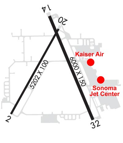
    Runway Identification: 02/20
    Length: 5202 ft
    Width: 100 ft
    Surface: ASPHALT-GOOD CONDITION
    Edge lights: Medium Intensity

    Treatment: GROOVED
    Weight: PCN 43 /F/C/W/T

     Runway: 02   Runway: 20
    Mag heading: 13°Mag heading: 193°
    Rwy Slope: -.29% DownRwy Slope: .29% Up
    Approach: Approach:
    Pattern: Left TrafficPattern: Left Traffic
    Markings: NONPRECISION INSTRUMENTMarkings: BASIC
    Marking Condition: GOODMarking Condition: GOOD
    Arresting Dev: Arresting Dev:
    Lat & Long: N3830.2  W12249.3Lat. & Long.: N3830.9  W12248.7
    Elev: 128.5 ft. MSLElev: 113.3 ft. MSL
    TCH: 50 ft. AGLTCH: 48 ft. AGL
    Visual Glide Path: 3.00 degreesVisual Glide Path: 3.50 degrees
    Displaced Threshold: NoDisplaced Threshold: No
    Touchdown Zone: YESTouchdown Zone: YES
    Touchdown Elev.: 128.7 feetTouchdown Elev.: 116.5 feet
    Visual Glide Slope: 2-Light PAPI on LEFT side of Runway; PAPI UNUSBL BYD 5 DEG LEFT OF CNTRLNVisual Glide Slope: 4-Light PAPI on LEFT side of Runway
    RVR Equipment: RVR Equipment:
    RVV Equipment: NORVV Equipment: NO
    Approach Lights: Approach Lights:
    REIL: NOREIL: NO
    Centerline Lights: NOCenterline Lights: NO
    Touchdown lights: NOTouchdown lights: NO
    Runway Category: Runway with a Non-precision Approach having visibility minimums greater than 3/4 mileRunway Category: Runway with a Visual Approach
    Declared Distances: TORA:5202' TODA:5202' ASDA:4802' LDA:4802'Declared Distances: TORA:5202' TODA:5202' ASDA:5202' LDA:5202'
    Obstructions: TREESObstructions: TREES
    Marked: NOT Marked/LightedMarked: NOT Marked/Lighted
    Clearance slope: 20:1Clearance slope: 30:1
    Obstruction height: 131 feet AGLObstruction height: 33 feet AGL
    Dist. from runway: 2900 feetDist. from runway: 1200 feet
    Centerline offset: Centerline offset: 200 feet right of centerline
    Comments: Comments:
    Runway Identification: 14/32
    Length: 6000 ft
    Width: 150 ft
    Surface: ASPHALT-GOOD CONDITION
    Edge lights: High Intensity

    Treatment: GROOVED
    Weight: PCN 52 /F/C/W/T

     Runway: 14   Runway: 32
    Mag heading: 141°Mag heading: 321°
    Rwy Slope: .17% UpRwy Slope: -.17% Down
    Approach: Approach: ILS
    Pattern: Right TrafficPattern: Left Traffic
    Markings: PRECISION INSTRUMENTMarkings: PRECISION INSTRUMENT
    Marking Condition: GOODMarking Condition: GOOD
    Arresting Dev: Arresting Dev:
    Lat & Long: N3831.1  W12248.8Lat. & Long.: N3830.1  W12248.3
    Elev: 110.5 ft. MSLElev: 120.4 ft. MSL
    TCH: 49 ft. AGLTCH:
    Visual Glide Path: 3.00 degreesVisual Glide Path:
    Displaced Threshold: NoDisplaced Threshold: No
    Touchdown Zone: YESTouchdown Zone: YES
    Touchdown Elev.: 119.6 feetTouchdown Elev.: 122.3 feet
    Visual Glide Slope: 4-Light PAPI on RIGHT side of RunwayVisual Glide Slope:
    RVR Equipment: ROLLOUTRVR Equipment: TOUCHDOWN
    RVV Equipment: NORVV Equipment: NO
    Approach Lights: Approach Lights: MALSR - 1,400 foot medium intensity approach lighting system with runway alignment indicator lights
    REIL: YESREIL: NO
    Centerline Lights: NOCenterline Lights: NO
    Touchdown lights: NOTouchdown lights: NO
    Runway Category: Runway with a Non-precision Approach having visibility minimums greater than 3/4 mileRunway Category: Precision Instrument Runway
    Declared Distances: TORA:6000' TODA:6000' ASDA:5880' LDA:5880'Declared Distances: TORA:6000' TODA:6000' ASDA:6000' LDA:6000'
    Obstructions: TREESObstructions: TREES
    Marked: NOT Marked/LightedMarked: NOT Marked/Lighted
    Clearance slope: 35:1Clearance slope: 45:1
    Obstruction height: 17 feet AGLObstruction height: 135 feet AGL
    Dist. from runway: 800 feetDist. from runway: 6400 feet
    Centerline offset: 250 left of centerlineCenterline offset:
    Comments: Comments:
    C:97/P: