Current Weather/Notams (Metars, TAFs, Notams, NWS Forecast, PIREPS, and nearby weather)
Customs Information Send updates to Support@FltPlan.com
Customs Not Available
Database effective 04/18/2024
Airport Diagram might not be current.
|
| Facility Name: | STEVENS POINT MUNI |
| City Name: | STEVENS POINT |
| County: | PORTAGE |
| State abbrev: | WI |
| State Name: | WISCONSIN |
| | |
| Ownership: | PUBLICLY OWNED |
| Use: | OPEN TO THE PUBLIC |
| Owner's Name: | STEVENS POINT |
| Address: | 1515 STRONGS AVE |
| | STEVENS POINT, WI 54481 |
| Owner's Phone: | 715-345-8989 |
| | |
| Manager's Name: | JASON DRAHEIM |
| Address: | 4501 HWY 66; EMAIL ADDRESS: JDRAHEIM@STEVENSPOINT.COM (ALL LOWER CASE) |
| | STEVENS POINT, WI 54482 |
| Phone: | 715-345-8993; AFT HRS CALL 715-345-8989; OPTION 3. |
| | |
| FAA Region: | GREAT LAKES |
| FAA Field Office: | CHI |
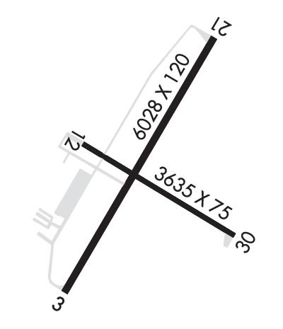
Runway Identifications
Runway Identification: 03/21Length: 6028 ft
Width: 120 ft
Surface: ASPHALT
Edge lights: High IntensityTreatment: NONE
| | Runway: 03 | | Runway: 21 |
| Mag heading: | 31° | Mag heading: | 211° |
| Rwy Slope: | .10% Up | Rwy Slope: | -.10% Down |
| Approach: | | Approach: | ILS/DME |
| Pattern: | Left Traffic | Pattern: | Left Traffic |
| Markings: | NONPRECISION INSTRUMENT | Markings: | NONPRECISION INSTRUMENT |
| Marking Condition: | GOOD | Marking Condition: | GOOD |
| Arresting Dev: | | Arresting Dev: | |
| Lat & Long: | N4432.3 W08932.2 | Lat. & Long.: | N4433.2 W08931.5 |
| Elev: | 1104.0 ft. MSL | Elev: | 1110.0 ft. MSL |
| TCH: | 44 ft. AGL | TCH: | 45 ft. AGL |
| Visual Glide Path: | 3.00 degrees | Visual Glide Path: | 3.00 degrees |
| Displaced Threshold: | No | Displaced Threshold: | No |
| Touchdown Zone: | YES | Touchdown Zone: | YES |
| Touchdown Elev.: | 1108.1 feet | Touchdown Elev.: | 1110.0 feet |
| Visual Glide Slope: | 2-Light PAPI on LEFT side of Runway | Visual Glide Slope: | 4-Light PAPI on LEFT side of Runway |
| RVR Equipment: | | RVR Equipment: | |
| RVV Equipment: | NO | RVV Equipment: | NO |
| Approach Lights: | | Approach Lights: | MALS - 1,400 foot medium intensity approach lighting system |
| REIL: | YES | REIL: | NO |
| Centerline Lights: | NO | Centerline Lights: | NO |
| Touchdown lights: | NO | Touchdown lights: | NO |
| Runway Category: | Runway with a Non-precision Approach having visibility minimums greater than 3/4 mile | Runway Category: | Precision Instrument Runway |
| Declared Distances: | | Declared Distances: | |
| Obstructions: | TREES | Obstructions: | TREES |
| Marked: | NOT Marked/Lighted | Marked: | NOT Marked/Lighted |
| Clearance slope: | 23:1 | Clearance slope: | 4:1 |
| Obstruction height: | 40 feet AGL | Obstruction height: | 16 feet AGL |
| Dist. from runway: | 1140 feet | Dist. from runway: | 265 feet |
| Centerline offset: | 600 left of centerline | Centerline offset: | 510 feet right of centerline |
| Comments: | | Comments: | |
Runway Identification: 12/30Length: 3635 ft
Width: 75 ft
Surface: ASPHALT-FAIR CONDITION
Edge lights: High IntensityTreatment: NONE
| | Runway: 12 | | Runway: 30 |
| Mag heading: | 121° | Mag heading: | 301° |
| Rwy Slope: | -.06% Down | Rwy Slope: | .06% Up |
| Approach: | | Approach: | |
| Pattern: | Left Traffic | Pattern: | Left Traffic |
| Markings: | NONPRECISION INSTRUMENT | Markings: | NONPRECISION INSTRUMENT |
| Marking Condition: | GOOD | Marking Condition: | GOOD |
| Arresting Dev: | | Arresting Dev: | |
| Lat & Long: | N4432.8 W08932.1 | Lat. & Long.: | N4432.5 W08931.4 |
| Elev: | 1105.0 ft. MSL | Elev: | 1103.0 ft. MSL |
| TCH: | | TCH: | |
| Visual Glide Path: | | Visual Glide Path: | |
| Displaced Threshold: | No | Displaced Threshold: | No |
| Touchdown Zone: | YES | Touchdown Zone: | YES |
| Touchdown Elev.: | 1108.1 feet | Touchdown Elev.: | 1108.1 feet |
| Visual Glide Slope: | | Visual Glide Slope: | |
| RVR Equipment: | | RVR Equipment: | |
| RVV Equipment: | NO | RVV Equipment: | NO |
| Approach Lights: | | Approach Lights: | |
| REIL: | NO | REIL: | NO |
| Centerline Lights: | NO | Centerline Lights: | NO |
| Touchdown lights: | NO | Touchdown lights: | NO |
| Runway Category: | Runway with a Non-precision Approach | Runway Category: | Runway with a Non-precision Approach |
| Declared Distances: | | Declared Distances: | |
| Obstructions: | TREES | Obstructions: | TREES |
| Marked: | NOT Marked/Lighted | Marked: | NOT Marked/Lighted |
| Clearance slope: | 9:1 | Clearance slope: | 9:1 |
| Obstruction height: | 56 feet AGL | Obstruction height: | 15 feet AGL |
| Dist. from runway: | 745 feet | Dist. from runway: | 340 feet |
| Centerline offset: | 320 right of centerline | Centerline offset: | 205 feet left of centerline |
| Comments: | | Comments: | |

