KSSI

ST SIMONS ISLAND
ST SIMONS ISLAND
GA
Time Zone: Eastern
Lat: N 3109.1
Long: W 08123.5
Elev: 19
Var: +05
Longest Runway: 5584
AWOS: 120.02
CTAF: 123.05

FBO & Flight Services info for KSSI

FBOs: Update your Fuel Prices

  click here  
We're proud to be the front door for general aviation to the Golden Isles of Georgia. We want you to be comfortable and enjoy your stay here. You'll like our beautiful facilities and our range of services including Pilots Lounge, Quiet Room, Conference Room, Showers, Full Kitchen, Courtesy Car, Concierge Service, Discount Lodging Reservations and Overnight Hangar Service.
Ph: 912-638-8617 Fax: 912-638-2928 Freq: 130.65WebsiteE-Mail
                     
Service
Jet
100LL
SAF
MoGas
Fuel Avail: PRIST + $0.04/gal. 7A-8P Daily, Answering Service for after hours call-out fee applies.
Full6.296.95    Last Update: 03/24/2024 11:33

Self  6.70    
Misc. Info: Address: 115 TERMINAL WAY SUITE 100.   ST. SIMONS ISLAND, GA 31522-2802

ASOSPh: 912-638-7042
-
Freq: 120.02  
If you are an FBO, call 1-203-262-1700 to update your info or email: FltPlan.Advertising@garmin.com
Advertise your FBO on FltPlan.com

Runway & Approach Info for KSSI
Rwy
Length
Land Dist**
Approach*
  Rwy
Length
Land Dist**
Approach*
04
5584x100  4802'          
 
  
22
  5584x100  4673'          
 
16
3313x75  3313'          
 
  
34
  3313x75  3313'          
 
 * only ILS, LOC, LDA, and SDF approaches to a specific runway are shown
** For any Declared Landing Distance Available, please see A/FD or Approach plates
Runway Weight Capability (lbs.) Help
Runway IDSingle WheelDouble WheelDouble Tandem WheelDual Double Wheel
04/2245,00060,000N/AN/A
16/3414,00030,000N/AN/A
These numbers are Advisory and are not limits.   The Airport Manager should have more accurate Weight Limits
Approach Charts
Approaches    
Current Weather/Notams
Customs Information Send updates to Support@FltPlan.com
Customs Not Available
Database effective 04/18/2024
Airport Diagram of KSSI
Airport Diagram might not be current.

Facility Name: ST SIMONS ISLAND
City Name: ST SIMONS ISLAND
County: GLYNN
State abbrev: GA
State Name: GEORGIA
   
Ownership: PUBLICLY OWNED
Use: OPEN TO THE PUBLIC
Owner's Name: GLYNN COUNTY - GLYNN CO. ARPT COMM.
Address: 295 AVIATION PARKWAY, SUITE 205
 BRUNSWICK, GA 31525
Owner's Phone: (912) 265-2070
  
Manager's Name: ROBERT BURR
Address: 295 AVIATION PARKWAY, SUITE 205
 BRUNSWICK, GA 31525
Phone: 912-265-2070
   
FAA Region: SOUTHERN
FAA Field Office: ATL
Joseph Pelton - www.aviationonlinetraining.net


Click here for full scale & interactive Sectional view of KSSI


Sunrise / Sunset times for ST SIMONS ISLAND

DateSunriseSunset
04/18/24 Thursday6:5319:57
04/19/24 Friday6:5219:57
04/20/24 Saturday6:5119:58
04/21/24 Sunday6:5019:59
04/22/24 Monday6:4919:59
04/23/24 Tuesday6:4820:00
04/24/24 Wednesday6:4720:01
04/25/24 Thursday6:4620:01
04/26/24 Friday6:4520:02
04/27/24 Saturday6:4420:03
04/28/24 Sunday6:4320:03
04/29/24 Monday6:4220:04
04/30/24 Tuesday6:4120:05
05/01/24 Wednesday6:4020:05

Airport Facilities

Airport Attendance Schedule7 Days A Week 0700-2000
Airport Status OPERATIONAL (This Status can change at any time - please check NOTAMS)
Airport Lighting ScheduleACTVT REIL RWY 04; HIRL RWY 04/22 & 16/34 - CTAF.
Airport Storage AvailableTie Downs, Hanger
Extra Services AvailableCharter, Flight Instruction, Aircraft Rental, Aircraft Sales
Wind IndicatorYES - (lighted)
Control TowerNO
CTAF Frequency123.050
Unicom Frequency123.050
Rotating Beacon ColorWG
Segmented CircleYES
Landing FeeNO

Airport Inspection Data

Airport InspectedSTATE - performed by STATE AERONAUTICAL PERSONNEL
Inspection Date05/11/2023

Airport Services

Type of Fuel AvailableGrade 100LL, JET A (freeze point -40C), JET A
Airframe Repair ServiceMAJOR
Power Plant Repair ServiceMINOR

Geographic Data

LatitudeN3109.1
LongitudeW08123.5 (ESTIMATED)
Arpt Elevation18ft (SURVEYED)
Magnetic Variation05W
1 miles Nof ST SIMONS ISLAND
Traffic Pattern Altitude
Sectional ChartJACKSONVILLE

Aircraft Data

Operations (Reported)YearlyAvg. Daily
General Aviation Transient 36410100
General Aviation Local 591016
Air Taxi 00
Commerical 00
Commuter 00
Military 7502
Aircraft based on Field
General Aviation Singles 62
General Aviation Multi 13
Jet Aircraft 2
General Aviation Helicopters 2
Military Aircraft 0
Gliders 2
Ultralights 0

FAA Services

FSS on field NO
FSS tie-in MACON
FSS Phone 1-800-WX-BRIEF
Who issues Notams SSI
Notam D service at airport YES
ARTCC Name JACKSONVILLE

Federal Status

Airport Certification
Aircraft Rescue & Firefighting IndexNone
Airport of EntryNo
Custom Landing RightsYES
Joint Civil/MilitaryNo
Military Landing rightsYES

Federal Agreements

NATIONAL PLAN OF INTEGRATED AIRPORT SYSTEMS (NPIAS)
GRANT AGREEMENTS UNDER FAAP/ADAP/AIP
SURPLUS PROPERTY AGREEMENT UNDER PUBLIC LAW 289
ASSURANCES PURSUANT TO TITLE VI, CIVIL RIGHTS ACT OF 1964
AGREEMENT UNDER DLAND OR DCLA HAS EXPIRED.

Remarks

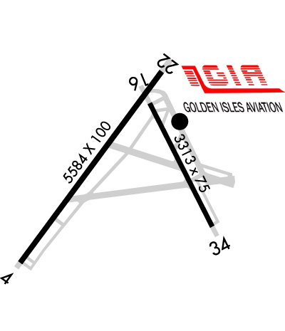
BIRDS AND WILDLIFE ON & INVOF ARPT.
PREF NOISE-ABATEMENT ARRIVAL FOR HEL TFC IS A STRAIGHT-IN TO RWY 34 THEN A MID-FIELD TURN TO LDG. ALL WHEELED HEL GND TAXI TO FINAL PRKG.
ADDITIONAL APT SAFETY BULLETINS POSTED AT WWW.FLYGCAIRPORTS.COM/SAFETY.
FOR CD CTC JACKSONVILLE ARTCC AT 904-845-1592.
FBO SVCS AVBL ON 130.65.
TGL FOR RWY 04-22 AND RWY 16-34 ARE NOT IN COMPLIANCE WITH NOISE PROGRAM.
USE CTN DUE TO CONGESTED ASP WITH TURBINE, NONTURBINE, AND TRNG ACFT. BQK LOCATED 7NM NW. JEKYLL ISLAND AP 09J LOCATED 4NM S USING SAME CTAF FREQ 123.05.
RWY 22 PREF FOR LIGHT AND VRB WINDS OR CROSSWINDS.
ALL VFR ACFT ADHERE TO STD LH TFC PAT.
ACFT DEPARTING RWY 34 USE EXTRM CTN- APCH END OF RWY 04 NOT VSB FROM APCH END OF RWY 34.
ALL ARRIVALS AND DEPARTURES, INCLUDING ACFT FLYING INST APPROACHES, ARE REQSTD TO RPRT 10 MILES FROM THE AP, INTNS AND PSN REPORTS TO -ST SIMONS- CTAF 123.05.
PPR FOR SVC AND FUEL AFTER HRS CALL 912-638-8617.
ADJ RESIDENTIAL AREA TO THE SE AND SSW OF RWY 16/34 EXTREMELY NOISE SENSITIVE.
Airport Communications & Frequencies:
CTAF Frequency:
123.050
Unicom Frequency:
123.050
Remarks
  • APCH/DEP SVC PRVDD BY JACKSONVILLE ARTCC (ZJX) ON FREQS 126.75/277.4 (BRUNSWICK RCAG).
  • Runway Identifications
    Runway Identification: 04/22
    Length: 5584 ft
    Width: 100 ft
    Surface: ASPHALT-GOOD CONDITION
    Edge lights: High Intensity

    Treatment: GROOVED
    Weight: PCN 38 /F/B/X/T

     Runway: 04   Runway: 22
    Mag heading: 41°Mag heading: 221°
    Rwy Slope: .10% UpRwy Slope: -.10% Down
    Approach: Approach:
    Pattern: Left TrafficPattern: Left Traffic
    Markings: NONPRECISION INSTRUMENTMarkings: NONPRECISION INSTRUMENT
    Marking Condition: GOODMarking Condition: GOOD
    Arresting Dev: Arresting Dev:
    Lat & Long: N3108.7  W08123.9Lat. & Long.: N3109.5  W08123.3
    Elev: 10.3 ft. MSLElev: 16.1 ft. MSL
    TCH: 57 ft. AGLTCH: 54 ft. AGL
    Visual Glide Path: 4.00 degreesVisual Glide Path: 4.00 degrees
    Displaced Threshold: 782 feetDisplaced Threshold: 911 feet
    Touchdown Zone: YESTouchdown Zone: YES
    Touchdown Elev.: 16.0 feetTouchdown Elev.: 17.4 feet
    Visual Glide Slope: 2-Light PAPI on LEFT side of RunwayVisual Glide Slope: 2-Light PAPI on LEFT side of Runway
    RVR Equipment: RVR Equipment:
    RVV Equipment: NORVV Equipment: NO
    Approach Lights: Approach Lights:
    REIL: YESREIL: NO
    Centerline Lights: NOCenterline Lights: NO
    Touchdown lights: NOTouchdown lights: NO
    Runway Category: Runway with a Non-precision Approach having visibility minimums greater than 3/4 mileRunway Category: Runway with a Non-precision Approach having visibility minimums greater than 3/4 mile
    Declared Distances: TORA:5580' TODA:5580' ASDA:5580' LDA:4798'Declared Distances: TORA:5580' TODA:5580' ASDA:5580' LDA:4671'
    Obstructions: ROADObstructions: TREES
    Marked: NOT Marked/LightedMarked: NOT Marked/Lighted
    Clearance slope: APCH RATIO 25:1 TO DSPLCD THR; 26 FT TREES 650 FT OUT AND 300 FT RIGHT.Clearance slope: APCH RATIO 50:1 TO DSPLCD THR.
    Obstruction height: 15 feet AGLObstruction height: 30 feet AGL
    Dist. from runway: 215 feetDist. from runway: 201 feet
    Centerline offset: 256 left of centerlineCenterline offset: 168 feet right of centerline
    Comments: +6 FT FENCE, +32 FT POWER POLE, +12 FT BUSH 75-200 FT FROM END OF RWY 228-250 FT LEFT.Comments: +30 FT TREE 150 FT FROM RWY END 165 FT RIGHT.
    Runway Identification: 16/34
    Length: 3313 ft
    Width: 75 ft
    Surface: ASPHALT
    Edge lights: High Intensity

    Treatment: NONE

     Runway: 16   Runway: 34
    Mag heading: 159°Mag heading: 339°
    Rwy Slope: -.18% DownRwy Slope: .18% Up
    Approach: Approach:
    Pattern: Left TrafficPattern: Left Traffic
    Markings: BASICMarkings: BASIC
    Marking Condition: GOODMarking Condition: GOOD
    Arresting Dev: Arresting Dev:
    Lat & Long: N3109.4  W08123.3Lat. & Long.: N3108.9  W08123.1
    Elev: 18.0 ft. MSLElev: 11.9 ft. MSL
    TCH: 46 ft. AGLTCH: 55 ft. AGL
    Visual Glide Path: 3.25 degreesVisual Glide Path: 3.75 degrees
    Displaced Threshold: NoDisplaced Threshold: No
    Touchdown Zone: YESTouchdown Zone: YES
    Touchdown Elev.: 18.9 feetTouchdown Elev.: 18.9 feet
    Visual Glide Slope: 2-Light PAPI on LEFT side of RunwayVisual Glide Slope: 2-Light PAPI on LEFT side of Runway
    RVR Equipment: RVR Equipment:
    RVV Equipment: NORVV Equipment: NO
    Approach Lights: Approach Lights:
    REIL: NOREIL: NO
    Centerline Lights: NOCenterline Lights: NO
    Touchdown lights: NOTouchdown lights: NO
    Runway Category: Runway with a Visual ApproachRunway Category: Runway with a Visual Approach
    Declared Distances: Declared Distances:
    Obstructions: TREESObstructions: TREES
    Marked: NOT Marked/LightedMarked: NOT Marked/Lighted
    Clearance slope: 18:1Clearance slope: 13:1
    Obstruction height: 30 feet AGLObstruction height: 47 feet AGL
    Dist. from runway: 740 feetDist. from runway: 845 feet
    Centerline offset: 150 right of centerlineCenterline offset: 150 feet left of centerline
    Comments: Comments:
    C:133/P: