Current Weather/Notams (Metars, TAFs, Notams, NWS Forecast, PIREPS, and nearby weather)
Customs Information Send updates to Support@FltPlan.com
Customs Not Available
Database effective 04/18/2024
Airport Diagram might not be current.
|
| Facility Name: | STINSON MUNI |
| City Name: | SAN ANTONIO |
| County: | BEXAR |
| State abbrev: | TX |
| State Name: | TEXAS |
| | |
| Ownership: | PUBLICLY OWNED |
| Use: | OPEN TO THE PUBLIC |
| Owner's Name: | CITY OF SAN ANTONIO |
| Address: | 8535 MISSION RD |
| | SAN ANTONIO, TX 78214 |
| Owner's Phone: | 210-207-1800 |
| | |
| Manager's Name: | MORRIS MARTIN |
| Address: | 8535 MISSION RD |
| | SAN ANTONIO, TX 78214 |
| Phone: | 210-207-1800 |
| | |
| FAA Region: | SOUTHWEST |
| FAA Field Office: | TEX |
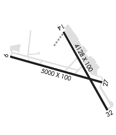
Runway Identifications
Runway Identification: 09/27Length: 5000 ft
Width: 100 ft
Surface: ASPHALT-GOOD CONDITION
Edge lights: Medium IntensityTreatment: NONE
| | Runway: 09 | | Runway: 27 |
| Mag heading: | 95° | Mag heading: | 275° |
| Rwy Slope: | -.25% Down | Rwy Slope: | .25% Up |
| Approach: | | Approach: | |
| Pattern: | Left Traffic | Pattern: | Left Traffic |
| Markings: | NONPRECISION INSTRUMENT | Markings: | NONPRECISION INSTRUMENT |
| Marking Condition: | GOOD | Marking Condition: | GOOD |
| Arresting Dev: | | Arresting Dev: | |
| Lat & Long: | N2920.3 W09828.9 | Lat. & Long.: | N2920.1 W09827.9 |
| Elev: | 577.6 ft. MSL | Elev: | 565.1 ft. MSL |
| TCH: | 40 ft. AGL | TCH: | 40 ft. AGL |
| Visual Glide Path: | 3.00 degrees | Visual Glide Path: | 3.00 degrees |
| Displaced Threshold: | 450 feet | Displaced Threshold: | No |
| Touchdown Zone: | YES | Touchdown Zone: | YES |
| Touchdown Elev.: | 576.9 feet | Touchdown Elev.: | 570.4 feet |
| Visual Glide Slope: | 4-Light PAPI on LEFT side of Runway | Visual Glide Slope: | 4-Light PAPI on LEFT side of Runway |
| RVR Equipment: | | RVR Equipment: | |
| RVV Equipment: | NO | RVV Equipment: | NO |
| Approach Lights: | | Approach Lights: | |
| REIL: | YES | REIL: | YES |
| Centerline Lights: | NO | Centerline Lights: | NO |
| Touchdown lights: | NO | Touchdown lights: | NO |
| Runway Category: | Runway with a Visual Approach | Runway Category: | Runway with a Visual Approach |
| Declared Distances: | | Declared Distances: | |
| Obstructions: | TREES | Obstructions: | POLE |
| Marked: | LIGHTED | Marked: | NOT Marked/Lighted |
| Clearance slope: | APCH SLOPE 23:1 TO DSPLCD THLD OVR 68 FT TREES, 1588 FT DSTC. | Clearance slope: | 7:1 |
| Obstruction height: | 29 feet AGL | Obstruction height: | 16 feet AGL |
| Dist. from runway: | 205 feet | Dist. from runway: | 318 feet |
| Centerline offset: | 25 left of centerline | Centerline offset: | 250 feet right of centerline |
| Comments: | 7 FT FENCE, 0 FT DSTC, 167 FT R; 15 FT RD O FT DSTC. | Comments: | |
Runway Identification: 14/32Length: 4128 ft
Width: 100 ft
Surface: ASPHALT-GOOD CONDITION
Edge lights: Medium IntensityTreatment: NONE
| | Runway: 14 | | Runway: 32 |
| Mag heading: | 137° | Mag heading: | 317° |
| Rwy Slope: | -.46% Down | Rwy Slope: | .46% Up |
| Approach: | | Approach: | |
| Pattern: | Left Traffic | Pattern: | Left Traffic |
| Markings: | NONPRECISION INSTRUMENT | Markings: | NONPRECISION INSTRUMENT |
| Marking Condition: | GOOD | Marking Condition: | GOOD |
| Arresting Dev: | | Arresting Dev: | |
| Lat & Long: | N2920.5 W09828.3 | Lat. & Long.: | N2919.9 W09827.9 |
| Elev: | 572.0 ft. MSL | Elev: | 552.9 ft. MSL |
| TCH: | 35 ft. AGL | TCH: | 40 ft. AGL |
| Visual Glide Path: | 3.00 degrees | Visual Glide Path: | 3.00 degrees |
| Displaced Threshold: | 583 feet | Displaced Threshold: | 372 feet |
| Touchdown Zone: | YES | Touchdown Zone: | YES |
| Touchdown Elev.: | 571.3 feet | Touchdown Elev.: | 570.7 feet |
| Visual Glide Slope: | 2-Light PAPI on RIGHT side of Runway | Visual Glide Slope: | 4-Light PAPI on LEFT side of Runway |
| RVR Equipment: | | RVR Equipment: | |
| RVV Equipment: | NO | RVV Equipment: | NO |
| Approach Lights: | | Approach Lights: | |
| REIL: | YES | REIL: | YES |
| Centerline Lights: | NO | Centerline Lights: | NO |
| Touchdown lights: | NO | Touchdown lights: | NO |
| Runway Category: | Runway with a Visual Approach | Runway Category: | Runway with a Non-precision Approach |
| Declared Distances: | | Declared Distances: | |
| Obstructions: | TREES | Obstructions: | TREES |
| Marked: | NOT Marked/Lighted | Marked: | NOT Marked/Lighted |
| Clearance slope: | APCH SLOPE 22:1 TO DSPLCD THLD OVR 50 FT TREES, 1100 FT DSTC. | Clearance slope: | APCH SLOPE 21:1 TO DSPLCD THLD OVR 40 FT TREES, 870 FT DSTC. |
| Obstruction height: | 35 feet AGL | Obstruction height: | 25 feet AGL |
| Dist. from runway: | 201 feet | Dist. from runway: | 201 feet |
| Centerline offset: | | Centerline offset: | |
| Comments: | 7 FT FENCE 21 FT DSTC. 14 FT RD, 35 FT DSTC ACRS APCH.. | Comments: | 6 FT FENCE 0 FT DSTC;15 FT RD 20 FT DSTC, 120 FT L |

