Current Weather/Notams (Metars, TAFs, Notams, NWS Forecast, PIREPS, and nearby weather)
Customs Information Send updates to Support@FltPlan.com
Customs Not Available
Database effective 04/18/2024
Airport Diagram might not be current.
|
| Facility Name: | SIERRA BLANCA RGNL |
| City Name: | RUIDOSO |
| County: | LINCOLN |
| State abbrev: | NM |
| State Name: | NEW MEXICO |
| | |
| Ownership: | PUBLICLY OWNED |
| Use: | OPEN TO THE PUBLIC |
| Owner's Name: | VILLAGE OF RUIDOSO |
| Address: | 313 CREE MEADOWS DR |
| | RUIDOSO, NM 88345 |
| Owner's Phone: | (575) 336-8111 |
| | |
| Manager's Name: | LEE BAKER |
| Address: | 313 CREE MEADOWS DR |
| | RUIDOSO, NM 88345 |
| Phone: | 575-336-8111 |
| | |
| FAA Region: | SOUTHWEST |
| FAA Field Office: | LNM |
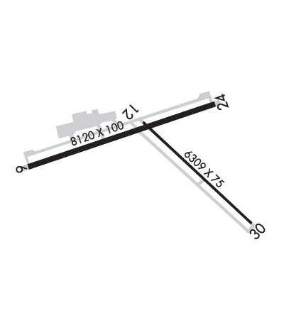
Runway Identifications
Runway Identification: 06/24Length: 8120 ft
Width: 100 ft
Surface: ASPHALT-FAIR CONDITION
Edge lights: Medium IntensityTreatment: POROUS FRICTION COURSE
Weight: PCN 26 /F/A/X/T
| | Runway: 06 | | Runway: 24 |
| Mag heading: | 61° | Mag heading: | 241° |
| Rwy Slope: | -.77% Down | Rwy Slope: | .77% Up |
| Approach: | | Approach: | ILS/DME |
| Pattern: | Left Traffic | Pattern: | Left Traffic |
| Markings: | NONPRECISION INSTRUMENT | Markings: | PRECISION INSTRUMENT |
| Marking Condition: | GOOD | Marking Condition: | GOOD |
| Arresting Dev: | | Arresting Dev: | |
| Lat & Long: | N3327.6 W10532.8 | Lat. & Long.: | N3328.0 W10531.3 |
| Elev: | 6813.5 ft. MSL | Elev: | 6751.0 ft. MSL |
| TCH: | 32 ft. AGL | TCH: | |
| Visual Glide Path: | 3.00 degrees | Visual Glide Path: | |
| Displaced Threshold: | No | Displaced Threshold: | No |
| Touchdown Zone: | YES | Touchdown Zone: | YES |
| Touchdown Elev.: | 6813.8 feet | Touchdown Elev.: | 6770.9 feet |
| Visual Glide Slope: | 2-Box VASI on LEFT side of Runway | Visual Glide Slope: | |
| RVR Equipment: | | RVR Equipment: | |
| RVV Equipment: | NO | RVV Equipment: | NO |
| Approach Lights: | | Approach Lights: | |
| REIL: | NO | REIL: | NO |
| Centerline Lights: | NO | Centerline Lights: | NO |
| Touchdown lights: | NO | Touchdown lights: | NO |
| Runway Category: | Runway with a Visual Approach | Runway Category: | Precision Instrument Runway |
| Declared Distances: | TORA:8120' TODA:8120' ASDA:8120' LDA:8120' | Declared Distances: | TORA:8120' TODA:8120' ASDA:8120' LDA:8120' |
Runway Identification: 12/30Length: 6309 ft
Width: 75 ft
Surface: ASPHALT-GOOD CONDITION
Edge lights: Medium IntensityTreatment: NONE
Weight: PCN 23 /F/C/X/T
| | Runway: 12 | | Runway: 30 |
| Mag heading: | 122° | Mag heading: | 302° |
| Rwy Slope: | -.81% Down | Rwy Slope: | .81% Up |
| Approach: | | Approach: | |
| Pattern: | Left Traffic | Pattern: | Left Traffic |
| Markings: | NONPRECISION INSTRUMENT | Markings: | NONPRECISION INSTRUMENT |
| Marking Condition: | GOOD | Marking Condition: | GOOD |
| Arresting Dev: | | Arresting Dev: | |
| Lat & Long: | N3327.9 W10531.9 | Lat. & Long.: | N3327.2 W10531.0 |
| Elev: | 6772.7 ft. MSL | Elev: | 6721.4 ft. MSL |
| TCH: | 40 ft. AGL | TCH: | 40 ft. AGL |
| Visual Glide Path: | 3.00 degrees | Visual Glide Path: | 3.00 degrees |
| Displaced Threshold: | No | Displaced Threshold: | No |
| Touchdown Zone: | YES | Touchdown Zone: | YES |
| Touchdown Elev.: | 6772.7 feet | Touchdown Elev.: | 6748.5 feet |
| Visual Glide Slope: | 2-Light PAPI on LEFT side of Runway | Visual Glide Slope: | 2-Light PAPI on LEFT side of Runway |
| RVR Equipment: | | RVR Equipment: | |
| RVV Equipment: | NO | RVV Equipment: | NO |
| Approach Lights: | | Approach Lights: | |
| REIL: | YES | REIL: | YES |
| Centerline Lights: | NO | Centerline Lights: | NO |
| Touchdown lights: | NO | Touchdown lights: | NO |
| Runway Category: | Runway with a Visual Approach | Runway Category: | Runway with a Visual Approach |
| Declared Distances: | TORA:6309' TODA:6309' ASDA:6309' LDA:6309' | Declared Distances: | TORA:6309' TODA:6309' ASDA:6309' LDA:6309' |

