
| ||||||||||||||||||||||||||||||||||||||||||||
| ||||||||||||||||||||||||||||||||||||||||||||
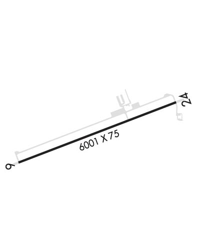
| Rwy | Rwy | |||||||
| 6001x75 | 6001' | 6001x75 | 6001' | |||||
| Runway ID | Single Wheel | Double Wheel | Double Tandem Wheel | Dual Double Wheel |
| 06/24 | 30,000 | N/A | N/A | N/A |
| These numbers are Advisory and are not limits. The Airport Manager should have more accurate Weight Limits | ||||
 Airport Diagram might not be current. | |
| Facility Name: | SILVER SPRINGS |
| City Name: | SILVER SPRINGS |
| County: | LYON |
| State abbrev: | NV |
| State Name: | NEVADA |
| Ownership: | PUBLICLY OWNED |
| Use: | OPEN TO THE PUBLIC |
| Owner's Name: | LYON COUNTY |
| Address: | 27 SOUTH MAIN ST |
| YERINGTON, NV 89447 | |
| Owner's Phone: | 775-577-2111 |
| Manager's Name: | CHRIS AUSTIN |
| Address: | P.O. BOX 313 |
| SILVER SPRINGS, NV 89429 | |
| Phone: | 775-686-0126 |
| FAA Region: | WESTERN-PACIFIC |
| FAA Field Office: | PHX |
| Date | Sunrise | Sunset |
|---|---|---|
| 04/18/24 Thursday | 6:14 | 19:39 |
| 04/19/24 Friday | 6:13 | 19:40 |
| 04/20/24 Saturday | 6:12 | 19:41 |
| 04/21/24 Sunday | 6:10 | 19:42 |
| 04/22/24 Monday | 6:09 | 19:43 |
| 04/23/24 Tuesday | 6:07 | 19:44 |
| 04/24/24 Wednesday | 6:06 | 19:45 |
| 04/25/24 Thursday | 6:05 | 19:46 |
| 04/26/24 Friday | 6:03 | 19:46 |
| 04/27/24 Saturday | 6:02 | 19:47 |
| 04/28/24 Sunday | 6:01 | 19:48 |
| 04/29/24 Monday | 6:00 | 19:49 |
| 04/30/24 Tuesday | 5:58 | 19:50 |
| 05/01/24 Wednesday | 5:57 | 19:51 |
| Airport Attendance Schedule | 7 Days A Week 0700-1900 |
| Airport Status | OPERATIONAL (This Status can change at any time - please check NOTAMS) |
| Airport Lighting Schedule | ACTVT REIL RWY 06 & 24; PAPI RWY 06 & 24; MIRL RWY 06/24 - CTAF. |
| Airport Storage Available | Tie Downs, Hanger |
| Extra Services Available | Air Ambulance, Glider, Flight Instruction, Glider Towing |
| Wind Indicator | YES - (lighted) |
| Control Tower | NO |
| CTAF Frequency | 122.900 |
| Unicom Frequency | |
| Rotating Beacon Color | WG |
| Segmented Circle | YES |
| Landing Fee | NO |
| Airport Inspected | STATE - performed by STATE AERONAUTICAL PERSONNEL |
| Inspection Date | 03/06/2024 |
| Type of Fuel Available | Grade 100LL, JET A (freeze point -40C); -10SELF SVC H24.; -A PPR OR CALLOUT. |
| Airframe Repair Service | None |
| Power Plant Repair Service | None |
| Latitude | N3924.2 |
| Longitude | W11915.1 (ESTIMATED) |
| Arpt Elevation | 4265ft (SURVEYED) |
| Magnetic Variation | 13E |
| 2 miles SW | of SILVER SPRINGS |
| Traffic Pattern Altitude | |
| Sectional Chart | SAN FRANCISCO |
| Operations (Reported) | Yearly | Avg. Daily |
|---|---|---|
| General Aviation Transient | 7260 | 20 |
| General Aviation Local | 3600 | 10 |
| Air Taxi | 0 | 0 |
| Commerical | 0 | 0 |
| Commuter | 0 | 0 |
| Military | 1820 | 5 |
| Aircraft based on Field | |
|---|---|
| General Aviation Singles | 15 |
| General Aviation Multi | 1 |
| Jet Aircraft | 0 |
| General Aviation Helicopters | 0 |
| Military Aircraft | 1 |
| Gliders | 0 |
| Ultralights | 0 |
| FSS on field | NO |
| FSS tie-in | RENO |
| FSS Phone | 1-800-WX-BRIEF |
| Who issues Notams | RNO |
| Notam D service at airport | YES |
| ARTCC Name | OAKLAND |
| Airport Certification | |
| Aircraft Rescue & Firefighting Index | None |
| Airport of Entry | No |
| Custom Landing Rights | No |
| Joint Civil/Military | No |
| Military Landing rights | No |
| NATIONAL PLAN OF INTEGRATED AIRPORT SYSTEMS (NPIAS) |
| 150 X 150 FT BLAST PAD BOTH ENDS. |
| FOR CD CTC NORCAL APCH AT 916-361-0596. |
Airport Communications & Frequencies:
| |||||||||||||||
| Runway: 06 | Runway: 24 | ||
| Mag heading: | N/A | Mag heading: | N/A |
| Rwy Slope: | -.84% Down | Rwy Slope: | .84% Up |
| Approach: | Approach: | ||
| Pattern: | Left Traffic | Pattern: | Right Traffic |
| Markings: | NONPRECISION INSTRUMENT | Markings: | NONPRECISION INSTRUMENT |
| Marking Condition: | GOOD | Marking Condition: | GOOD |
| Arresting Dev: | Arresting Dev: | ||
| Lat & Long: | N3924.0 W11915.7 | Lat. & Long.: | N3924.4 W11914.5 |
| Elev: | 4265.2 ft. MSL | Elev: | 4214.6 ft. MSL |
| TCH: | 40 ft. AGL | TCH: | 40 ft. AGL |
| Visual Glide Path: | 3.00 degrees | Visual Glide Path: | 3.00 degrees |
| Displaced Threshold: | No | Displaced Threshold: | No |
| Touchdown Zone: | YES | Touchdown Zone: | YES |
| Touchdown Elev.: | 4265.2 feet | Touchdown Elev.: | 4237.3 feet |
| Visual Glide Slope: | 2-Light PAPI on LEFT side of Runway | Visual Glide Slope: | 2-Light PAPI on LEFT side of Runway |
| RVR Equipment: | RVR Equipment: | ||
| RVV Equipment: | NO | RVV Equipment: | NO |
| Approach Lights: | Approach Lights: | ||
| REIL: | YES | REIL: | YES |
| Centerline Lights: | NO | Centerline Lights: | NO |
| Touchdown lights: | NO | Touchdown lights: | NO |
| Runway Category: | Runway with a Visual Approach | Runway Category: | Runway with a Visual Approach |
| Declared Distances: | Declared Distances: |