
| |||||||||||||||||||||||||||||||||||||||||||||||||||||||||||||
| |||||||||||||||||||||||||||||||||||||||||||||||||||||||||||||
| Rwy | Rwy | |||||||
| 6500x100 | 6500' | 6500x100 | 6500' | |||||
| Runway ID | Single Wheel | Double Wheel | Double Tandem Wheel | Dual Double Wheel |
| 12/30 | 24,000 | 36,000 | N/A | N/A |
| These numbers are Advisory and are not limits. The Airport Manager should have more accurate Weight Limits | ||||
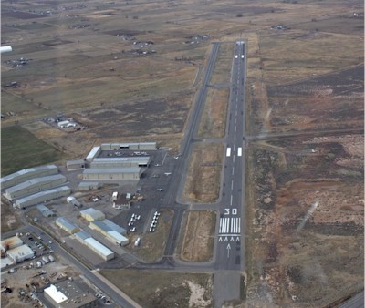
| Facility Name: | SPANISH FORK MUNI/WOODHOUSE FLD |
| City Name: | SPANISH FORK |
| County: | UTAH |
| State abbrev: | UT |
| State Name: | UTAH |
| Ownership: | PUBLICLY OWNED |
| Use: | OPEN TO THE PUBLIC |
| Owner's Name: | SPANISH FORK & SPRINGVILLE |
| Address: | 2050 NORTH 300 WEST |
| SPANISH FORK, UT 84660 | |
| Owner's Phone: | 801-798-5000 |
| Manager's Name: | CHRISTIAN DAVIS |
| Address: | 2050 NORTH 300 WEST |
| SPANISH FORK, UT 84660 | |
| Phone: | 801-804-4593; ALSO 801-798-9888. |
| FAA Region: | NORTHWEST MOUNTAIN |
| FAA Field Office: | DEN |
| Date | Sunrise | Sunset |
|---|---|---|
| 04/23/24 Tuesday | 6:36 | 20:14 |
| 04/24/24 Wednesday | 6:35 | 20:15 |
| 04/25/24 Thursday | 6:33 | 20:16 |
| 04/26/24 Friday | 6:32 | 20:17 |
| 04/27/24 Saturday | 6:30 | 20:18 |
| 04/28/24 Sunday | 6:29 | 20:20 |
| 04/29/24 Monday | 6:28 | 20:21 |
| 04/30/24 Tuesday | 6:27 | 20:22 |
| 05/01/24 Wednesday | 6:25 | 20:23 |
| 05/02/24 Thursday | 6:24 | 20:24 |
| 05/03/24 Friday | 6:23 | 20:25 |
| 05/04/24 Saturday | 6:22 | 20:26 |
| 05/05/24 Sunday | 6:21 | 20:27 |
| 05/06/24 Monday | 6:19 | 20:28 |
| Airport Attendance Schedule | MON-SAT 0900-1700; FOR AFTR HRS ATTENDANT 801-798-9888. |
| Airport Status | OPERATIONAL (This Status can change at any time - please check NOTAMS) |
| Airport Lighting Schedule | ACTVT REIL RWY 12 & 30; PAPI RWY 12 & 30; MIRL RWY 12/30 - CTAF. |
| Airport Storage Available | Tie Downs, Hanger |
| Extra Services Available | Avionics, Flight Instruction, Aircraft Rental |
| Wind Indicator | YES - (lighted) |
| Control Tower | NO |
| CTAF Frequency | 122.900 |
| Unicom Frequency | |
| Rotating Beacon Color | WG |
| Segmented Circle | YES |
| Landing Fee |
| Airport Inspected | STATE - performed by PRIVATE CONTRACT PERSONNEL |
| Inspection Date | 09/28/2023 |
| Type of Fuel Available | Grade 100LL, JET A (freeze point -40C); -10SELF SVC 100LL AVBL 24 HRS.; -A FOR JET A FUEL CALL 801-798-9888. |
| Airframe Repair Service | MAJOR |
| Power Plant Repair Service | MAJOR |
| Latitude | N4008.7 |
| Longitude | W11140.1 (ESTIMATED) |
| Arpt Elevation | 4529ft (ESTIMATED) |
| Magnetic Variation | 11E |
| 2 miles N | of SPANISH FORK |
| Traffic Pattern Altitude | TPA FOR FIXED WING ACFT IS 1000 FT AGL; TPA FOR ROTARY WING ACFT IS 500 FT AGL. |
| Sectional Chart | SALT LAKE CITY |
| Operations (Reported) | Yearly | Avg. Daily |
|---|---|---|
| General Aviation Transient | 15000 | 41 |
| General Aviation Local | 65000 | 178 |
| Air Taxi | 0 | 0 |
| Commerical | 0 | 0 |
| Commuter | 0 | 0 |
| Military | 100 | 0 |
| Aircraft based on Field | |
|---|---|
| General Aviation Singles | 225 |
| General Aviation Multi | 15 |
| Jet Aircraft | 16 |
| General Aviation Helicopters | 17 |
| Military Aircraft | 0 |
| Gliders | 1 |
| Ultralights | 0 |
| FSS on field | NO |
| FSS tie-in | CEDAR CITY |
| FSS Phone | 1-800-WX-BRIEF |
| Who issues Notams | CDC |
| Notam D service at airport | YES |
| ARTCC Name | SALT LAKE CITY |
| Airport Certification | |
| Aircraft Rescue & Firefighting Index | None |
| Airport of Entry | No |
| Custom Landing Rights | No |
| Joint Civil/Military | No |
| Military Landing rights | YES |
| NATIONAL PLAN OF INTEGRATED AIRPORT SYSTEMS (NPIAS) |
| GRANT AGREEMENTS UNDER FAAP/ADAP/AIP |
| ASSURANCES PURSUANT TO TITLE VI, CIVIL RIGHTS ACT OF 1964 |
| DEER & BIRDS ON & INVOF ARPT. |
| NOISE ABATEMENT PROCEDURES IN EFFECT. CALL ARPT MGR 801-798-9888. |
| DEC-FEB EXPECT UP TO 24 HRS AFTER STORM BEFORE RY PLOWING. RESIDUAL SNOW & ICE ON RY AFTER PLOWING. FOR STATUS CALL 801-798-9888/9. |
| FOR CD CTC SALT LAKE CITY APCH AT 801-325-9670. |
| RWY 12/30 RWY MARKINGS FADED. |
| COLD TEMPERATURE AIRPORT. ALTITUDE CORRECTION REQUIRED AT OR BELOW -21C. |
| RWY 12 APCH, 60 FT MKD/LGTD PLINE, 1475 FT DSTC, 0 FT BOTH, APCH SLOPE 21:1. |
| RWY 30 HEL ARR RWY 30 MUST CTC ARPT PRIOR TO ARR FOR TFC PAT INFO. |
Airport Communications & Frequencies:
| ||||||||||||
| Runway: 12 | Runway: 30 | ||
| Mag heading: | 121° | Mag heading: | 301° |
| Rwy Slope: | .08% Up | Rwy Slope: | -.08% Down |
| Approach: | Approach: | ||
| Pattern: | Left Traffic | Pattern: | Left Traffic |
| Markings: | NONPRECISION INSTRUMENT | Markings: | NONPRECISION INSTRUMENT |
| Marking Condition: | POOR | Marking Condition: | POOR |
| Arresting Dev: | Arresting Dev: | ||
| Lat & Long: | N4009.1 W11140.6 | Lat. & Long.: | N4008.3 W11139.5 |
| Elev: | 4523.9 ft. MSL | Elev: | 4528.8 ft. MSL |
| TCH: | 32 ft. AGL | TCH: | 35 ft. AGL |
| Visual Glide Path: | 3.00 degrees | Visual Glide Path: | 3.00 degrees |
| Displaced Threshold: | No | Displaced Threshold: | No |
| Touchdown Zone: | YES | Touchdown Zone: | YES |
| Touchdown Elev.: | 4526.7 feet | Touchdown Elev.: | 4529.4 feet |
| Visual Glide Slope: | 4-Light PAPI on LEFT side of Runway | Visual Glide Slope: | 4-Light PAPI on LEFT side of Runway |
| RVR Equipment: | RVR Equipment: | ||
| RVV Equipment: | NO | RVV Equipment: | NO |
| Approach Lights: | Approach Lights: | ||
| REIL: | YES | REIL: | YES |
| Centerline Lights: | NO | Centerline Lights: | NO |
| Touchdown lights: | NO | Touchdown lights: | NO |
| Runway Category: | Runway with a Visual Approach | Runway Category: | Runway with a Visual Approach |
| Declared Distances: | Declared Distances: | ||
| Obstructions: | Obstructions: | ROAD | |
| Marked: | Marked: | NOT Marked/Lighted | |
| Clearance slope: | 20:1 | Clearance slope: | 20:1 |
| Obstruction height: | Obstruction height: | 16 feet AGL | |
| Dist. from runway: | Dist. from runway: | 350 feet | |
| Centerline offset: | Centerline offset: | ||
| Comments: | Comments: |
