Current Weather/Notams (Metars, TAFs, Notams, NWS Forecast, PIREPS, and nearby weather)
Customs Information Send updates to Support@FltPlan.com
Customs Not Available
Database effective 05/16/2024
Airport Diagram might not be current.
|
| Facility Name: | ALBERT WHITTED |
| City Name: | ST PETERSBURG |
| County: | PINELLAS |
| State abbrev: | FL |
| State Name: | FLORIDA |
| | |
| Ownership: | PUBLICLY OWNED |
| Use: | OPEN TO THE PUBLIC |
| Owner's Name: | CITY OF ST PETERSBURG |
| Address: | 107 8TH AVENUE, S.E. |
| | ST PETERSBURG, FL 33701 |
| Owner's Phone: | 727-893-7654 |
| | |
| Manager's Name: | RICH LESNIAK |
| Address: | ALBERT WHITTED AIRPORT, 107 8TH AVENUE SOUTHEAST |
| | ST PETERSBURG, FL 33701 |
| Phone: | 727-893-7657; 727-893-7654 |
| | |
| FAA Region: | SOUTHERN |
| FAA Field Office: | ORL |
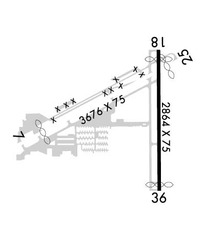
Runway Identifications
Runway Identification: 07/25Length: 3676 ft
Width: 75 ft
Surface: ASPHALT
Edge lights: Medium IntensityTreatment: NONE
Weight: PCN 9 /F/B/X/T
| | Runway: 07 | | Runway: 25 |
| Mag heading: | 67° | Mag heading: | 247° |
| Rwy Slope: | .02% Up | Rwy Slope: | -.02% Down |
| Approach: | | Approach: | |
| Pattern: | Right Traffic | Pattern: | Left Traffic |
| Markings: | NONPRECISION INSTRUMENT | Markings: | BASIC |
| Marking Condition: | FAIR | Marking Condition: | FAIR |
| Arresting Dev: | | Arresting Dev: | |
| Lat & Long: | N2745.8 W08238.0 | Lat. & Long.: | N2746.1 W08237.4 |
| Elev: | 5.3 ft. MSL | Elev: | 5.9 ft. MSL |
| TCH: | 40 ft. AGL | TCH: | 40 ft. AGL |
| Visual Glide Path: | 3.31 degrees | Visual Glide Path: | 3.90 degrees |
| Displaced Threshold: | 557 feet | Displaced Threshold: | 263 feet |
| Touchdown Zone: | YES | Touchdown Zone: | YES |
| Touchdown Elev.: | 6.6 feet | Touchdown Elev.: | 6.6 feet |
| Visual Glide Slope: | 2-Light PAPI on LEFT side of Runway | Visual Glide Slope: | 2-Light PAPI on LEFT side of Runway |
| RVR Equipment: | | RVR Equipment: | |
| RVV Equipment: | NO | RVV Equipment: | NO |
| Approach Lights: | | Approach Lights: | |
| REIL: | YES | REIL: | YES |
| Centerline Lights: | NO | Centerline Lights: | NO |
| Touchdown lights: | NO | Touchdown lights: | NO |
| Runway Category: | Runway with a Non-precision Approach | Runway Category: | Runway with a Visual Approach |
| Declared Distances: | TORA:3646' TODA:3646' ASDA:3376' LDA:2849' | Declared Distances: | TORA:3180' TODA:3180' ASDA:3312' LDA:3042' |
| Obstructions: | TREES | Obstructions: | BOAT |
| Marked: | NOT Marked/Lighted | Marked: | NOT Marked/Lighted |
| Clearance slope: | CTLG OBSTN EXCEEDS A 45 DEG SLP. RWY 07 APCH RATIOS 20:1 FM DTHR. | Clearance slope: | 15:1; RWY 25 APCH RATIO 25:1 FM DTHR. |
| Obstruction height: | 30 feet AGL | Obstruction height: | 52 feet AGL |
| Dist. from runway: | 205 feet | Dist. from runway: | 1020 feet |
| Centerline offset: | | Centerline offset: | |
| Comments: | 19 FT BLAST FENCE AT RWY END, 15 FT STREET 5 FT FM RWY END, 24 FT BLDG 100 FT FM RWY END. | Comments: | |
Runway Identification: 18/36Length: 2864 ft
Width: 75 ft
Surface: ASPHALT
Edge lights: Medium IntensityTreatment: NONE
Weight: PCN 14 /F/A/X/T
| | Runway: 18 | | Runway: 36 |
| Mag heading: | 185° | Mag heading: | 5° |
| Rwy Slope: | -.02% Down | Rwy Slope: | .02% Up |
| Approach: | | Approach: | |
| Pattern: | Left Traffic | Pattern: | Right Traffic |
| Markings: | NONPRECISION INSTRUMENT | Markings: | NONPRECISION INSTRUMENT |
| Marking Condition: | GOOD | Marking Condition: | GOOD |
| Arresting Dev: | | Arresting Dev: | |
| Lat & Long: | N2746.1 W08237.5 | Lat. & Long.: | N2745.6 W08237.5 |
| Elev: | 5.3 ft. MSL | Elev: | 4.6 ft. MSL |
| TCH: | 48 ft. AGL | TCH: | 45 ft. AGL |
| Visual Glide Path: | 4.00 degrees | Visual Glide Path: | 4.00 degrees |
| Displaced Threshold: | 190 feet | Displaced Threshold: | 115 feet |
| Touchdown Zone: | YES | Touchdown Zone: | YES |
| Touchdown Elev.: | 5.8 feet | Touchdown Elev.: | 5.8 feet |
| Visual Glide Slope: | 2-Light PAPI on RIGHT side of Runway | Visual Glide Slope: | 2-Light PAPI on LEFT side of Runway |
| RVR Equipment: | | RVR Equipment: | |
| RVV Equipment: | NO | RVV Equipment: | NO |
| Approach Lights: | | Approach Lights: | |
| REIL: | YES | REIL: | YES |
| Centerline Lights: | NO | Centerline Lights: | NO |
| Touchdown lights: | NO | Touchdown lights: | NO |
| Runway Category: | Runway with a Non-precision Approach | Runway Category: | Runway with a Non-precision Approach |
| Declared Distances: | | Declared Distances: | |
| Obstructions: | BOAT | Obstructions: | BOAT |
| Marked: | MARKED and LIGHTED | Marked: | NOT Marked/Lighted |
| Clearance slope: | 20:1; RWY 36 APRCH SLP 20:1 TO DTHR. | Clearance slope: | 11:1 |
| Obstruction height: | 40 feet AGL | Obstruction height: | 37 feet AGL |
| Dist. from runway: | 1000 feet | Dist. from runway: | 614 feet |
| Centerline offset: | | Centerline offset: | |
| Comments: | | Comments: | |

