Click here for more info on on SMS!

KSPF

BLACK HILLS-CLYDE ICE FIELD
SPEARFISH
SD
Time Zone: Mountain
Lat: N 4428.9
Long: W 10347.2
Elev: 3933
Var: -11
Longest Runway: 6401
AWOS: 118.32
CTAF: 122.7

FBO & Flight Services info for KSPF

FBOs: Update your Fuel Prices

  click here  
At Eagle Aviation, you can expect the best quality customer service for all your aircraft needs. Upon arrival, our staff will help you obtain fuel and parking. We have competitively priced 100LL Avgas and Jet-A fuels available. Overnight tiedowns are free at Black Hills Airport.
Ph: 800-843-8010 Fax: 605-642-1838 Freq: 122.7WebsiteE-Mail
                                  
Service
Jet
100LL
SAF
MoGas
Fuel Avail: M-F 7am-5pm, S-S 8am-5pm, Call-out available
Full6.296.59    Last Update: 04/07/2024 12:49

Self        
Misc. Info: Address: 300 AVIATION PLACE   SPEARFISH, SD 57783

AWOSPh: 605-642-8536
-
Freq: 118.32  
If you are an FBO, call 1-203-262-1700 to update your info or email: FltPlan.Advertising@garmin.com
Advertise your FBO on FltPlan.com

Runway & Approach Info for KSPF
Rwy
Length
Land Dist**
Approach*
  Rwy
Length
Land Dist**
Approach*
04
1995x120  1995'          
 
  
22
  1995x120  1995'          
 
08
4003x100  4003'          
 
  
26
  4003x100  4003'          
 
13
6401x75  6401'          
 
  
31
  6401x75  6401'          
 
 * only ILS, LOC, LDA, and SDF approaches to a specific runway are shown
** For any Declared Landing Distance Available, please see A/FD or Approach plates
Runway Weight Capability (lbs.) Help
Runway IDSingle WheelDouble WheelDouble Tandem WheelDual Double Wheel
04/22N/AN/AN/AN/A
08/26N/AN/AN/AN/A
13/3133,00045,000N/AN/A
These numbers are Advisory and are not limits.   The Airport Manager should have more accurate Weight Limits
Approach Charts
Approaches    
Current Weather/Notams
Customs Information Send updates to Support@FltPlan.com
Customs Not Available
Database effective 04/18/2024
Airport Diagram of KSPF
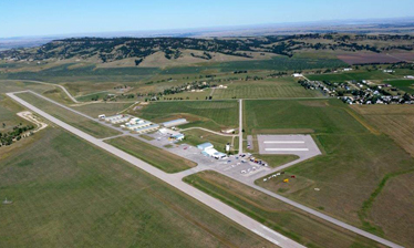
Airport Diagram might not be current.

Facility Name: BLACK HILLS-CLYDE ICE FLD
City Name: SPEARFISH
County: LAWRENCE
State abbrev: SD
State Name: SOUTH DAKOTA
   
Ownership: PUBLICLY OWNED
Use: OPEN TO THE PUBLIC
Owner's Name: CITY OF SPEARFISH
Address: 625 NORTH FIFTH STREET
 SPEARFISH, SD 57783
Owner's Phone: 605-642-1333
  
Manager's Name: RAY JILEK
Address: 300 AVIATION PLACE
 SPEARFISH, SD 57783
Phone: 605-642-4112
   
FAA Region: GREAT LAKES
FAA Field Office: DMA


Sunrise / Sunset times for BLACK HILLS-CLYDE ICE FLD

DateSunriseSunset
04/18/24 Thursday6:0519:45
04/19/24 Friday6:0319:46
04/20/24 Saturday6:0119:47
04/21/24 Sunday6:0019:48
04/22/24 Monday5:5819:50
04/23/24 Tuesday5:5719:51
04/24/24 Wednesday5:5519:52
04/25/24 Thursday5:5319:53
04/26/24 Friday5:5219:54
04/27/24 Saturday5:5019:56
04/28/24 Sunday5:4919:57
04/29/24 Monday5:4719:58
04/30/24 Tuesday5:4619:59
05/01/24 Wednesday5:4420:01

Airport Facilities

Airport Attendance Schedule7 Days A Week 0730-DUSK; FOR ATTENDANT AFT HRS CALL 605-642-2656/641-2787.
Airport Status OPERATIONAL (This Status can change at any time - please check NOTAMS)
Airport Lighting ScheduleACTVT MIRL RY 13/31; PAPI RYS 13 & 31 AND TWY A LGTS- CTAF.
Airport Storage AvailableTie Downs, Hanger
Extra Services AvailableAir Freight, Crop Dusting, Air Ambulance, Cargo Handling, Charter, Glider, Flight Instruction, Aircraft Rental, Aircraft Sales, Annual Surveying
Wind IndicatorYES - (lighted)
Control TowerNO
CTAF Frequency122.700
Unicom Frequency122.700
Rotating Beacon ColorWG
Segmented CircleYES
Landing FeeNO

Airport Inspection Data

Airport InspectedSTATE - performed by STATE AERONAUTICAL PERSONNEL
Inspection Date07/25/2023

Airport Services

Type of Fuel AvailableGrade 100LL, JET A (freeze point -40C)
Airframe Repair ServiceMAJOR
Power Plant Repair ServiceMAJOR

Geographic Data

LatitudeN4428.9
LongitudeW10347.2 (ESTIMATED)
Arpt Elevation3933ft (SURVEYED)
Magnetic Variation11E
3 miles Eof SPEARFISH
Traffic Pattern Altitude
Sectional ChartCHEYENNE

Aircraft Data

Operations (Reported)YearlyAvg. Daily
General Aviation Transient 400011
General Aviation Local 1100030
Air Taxi 12003
Commerical 00
Commuter 00
Military 8002
Aircraft based on Field
General Aviation Singles 61
General Aviation Multi 3
Jet Aircraft 0
General Aviation Helicopters 2
Military Aircraft 0
Gliders 1
Ultralights 0

FAA Services

FSS on field NO
FSS tie-in HURON
FSS Phone 1-800-WX-BRIEF
Who issues Notams SPF
Notam D service at airport YES
ARTCC Name DENVER

Federal Status

Airport Certification
Aircraft Rescue & Firefighting IndexNone
Airport of EntryNo
Custom Landing RightsNo
Joint Civil/MilitaryNo
Military Landing rightsYES

Federal Agreements

NATIONAL PLAN OF INTEGRATED AIRPORT SYSTEMS (NPIAS)
GRANT AGREEMENTS UNDER FAAP/ADAP/AIP
ASSURANCES PURSUANT TO TITLE VI, CIVIL RIGHTS ACT OF 1964

Remarks

HIGH VOL OF ACFT OPRNG INVOF OF MT RUSHMORE AND CRAZY HORSE MONUMENTS AT OR BLW 7500 FT; PILOTS ARE ADVISED TO MNT 122.85 FOR TFC ADVISORIES.
IREG OPNS IN & OUT OF PVT AIRFIELD LOCATED APRXLY 3300 FT S OF ARPT; CHECK CTAF FREQ FOR STATUS.
RY 22 +4 FT FENCE 50 FT R 141 FT FM THLD & 50 FT L 175 FT FM THLD.,
NO SNOW REMOVAL ON TURF RYS, CFM CONDS WITH AMGR, CALL 605-642-4112/2656.
ULTRALIGHT ACTIVITY ON & INVOF ARPT.
GCO AVBL ON FREQ 121.725 (4 CLICKS TO ELLSWORTH APPROACH AND 6 CLICKS TO DENVER CENTER)
FOR CD CTC ELLSWORTH APCH AT 605-385-6198, WHEN APCH CLSD CTC DENVER ARTCC AT 303-651-4257.
Airport Communications & Frequencies:
CTAF Frequency:
122.700
Unicom Frequency:
122.700
Remarks
  • APCH/DEP CTL SVC PRVDD BY DENVER ARTCC (ZDV) ON FREQS 127.95/338.2 (RAPID CITY RCAG) WHEN ELLSWORTH APCH CTL (RCA) CLSD.
  • ELLSWORTH Primary Approach Frequencies:  
    119.5
    259.1
    ELLSWORTH Primary Departure Frequencies:  
    119.5
    289.4
    Runway Identifications
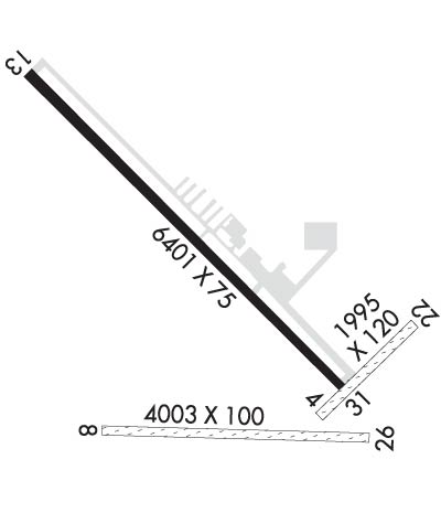
    Runway Identification: 04/22
    Length: 1995 ft
    Width: 120 ft
    Surface: GRASS-GOOD CONDITION
    Edge lights:

    Treatment: NONE

     Runway: 04   Runway: 22
    Mag heading: 34°Mag heading: 214°
    Rwy Slope: -1.85% DownRwy Slope: 1.85% Up
    Approach: Approach:
    Pattern: Left TrafficPattern: Left Traffic
    Markings: Markings:
    Marking Condition: RY 04/22 & RY 08/26 MARKED WITH BLACK & WHITE EDGE MARKERS.Marking Condition:
    Arresting Dev: Arresting Dev:
    Lat & Long: N4428.6  W10346.9Lat. & Long.: N4428.9  W10346.5
    Elev: 3903.9 ft. MSLElev: 3866.9 ft. MSL
    TCH: TCH:
    Visual Glide Path: Visual Glide Path:
    Displaced Threshold: NoDisplaced Threshold: No
    Touchdown Zone: YESTouchdown Zone: YES
    Touchdown Elev.: 3903.9 feetTouchdown Elev.: 3903.9 feet
    Visual Glide Slope: Visual Glide Slope:
    RVR Equipment: RVR Equipment:
    RVV Equipment: NORVV Equipment: NO
    Approach Lights: Approach Lights:
    REIL: NOREIL: NO
    Centerline Lights: NOCenterline Lights: NO
    Touchdown lights: NOTouchdown lights: NO
    Runway Category: Runway with a Visual ApproachRunway Category: Runway with a Visual Approach
    Declared Distances: Declared Distances:
    Obstructions: ROADObstructions: FENCE
    Marked: NOT Marked/LightedMarked: NOT Marked/Lighted
    Clearance slope: 36:1Clearance slope: 50:1
    Obstruction height: 18 feet AGLObstruction height: 1 feet AGL
    Dist. from runway: 650 feetDist. from runway: 150 feet
    Centerline offset: Centerline offset:
    Comments: Comments:
    Runway Identification: 08/26
    Length: 4003 ft
    Width: 100 ft
    Surface: GRASS-GOOD CONDITION
    Edge lights:

    Treatment: NONE

     Runway: 08   Runway: 26
    Mag heading: 81°Mag heading: 261°
    Rwy Slope: -.78% DownRwy Slope: .78% Up
    Approach: Approach:
    Pattern: Left TrafficPattern: Left Traffic
    Markings: Markings:
    Marking Condition: Marking Condition:
    Arresting Dev: Arresting Dev:
    Lat & Long: N4428.6  W10347.6Lat. & Long.: N4428.6  W10346.7
    Elev: 3932.8 ft. MSLElev: 3901.5 ft. MSL
    TCH: TCH:
    Visual Glide Path: Visual Glide Path:
    Displaced Threshold: NoDisplaced Threshold: No
    Touchdown Zone: YESTouchdown Zone: YES
    Touchdown Elev.: 3933.1 feetTouchdown Elev.: 3930.7 feet
    Visual Glide Slope: Visual Glide Slope:
    RVR Equipment: RVR Equipment:
    RVV Equipment: NORVV Equipment: NO
    Approach Lights: Approach Lights:
    REIL: NOREIL: NO
    Centerline Lights: NOCenterline Lights: NO
    Touchdown lights: NOTouchdown lights: NO
    Runway Category: Runway with a Visual ApproachRunway Category: Runway with a Visual Approach
    Declared Distances: Declared Distances:
    Obstructions: TREEObstructions:
    Marked: NOT Marked/LightedMarked:
    Clearance slope: 18:1Clearance slope: 50:1
    Obstruction height: 26 feet AGLObstruction height:
    Dist. from runway: 468 feetDist. from runway:
    Centerline offset: 27 left of centerlineCenterline offset:
    Comments: Comments:
    Runway Identification: 13/31
    Length: 6401 ft
    Width: 75 ft
    Surface: ASPHALT-GOOD CONDITION
    Edge lights: Medium Intensity

    Treatment: NONE

     Runway: 13   Runway: 31
    Mag heading: 124°Mag heading: 304°
    Rwy Slope: .17% UpRwy Slope: -.17% Down
    Approach: Approach:
    Pattern: Right TrafficPattern: Left Traffic
    Markings: NONPRECISION INSTRUMENTMarkings: NONPRECISION INSTRUMENT
    Marking Condition: GOODMarking Condition: GOOD
    Arresting Dev: Arresting Dev:
    Lat & Long: N4429.4  W10347.8Lat. & Long.: N4428.7  W10346.8
    Elev: 3884.0 ft. MSLElev: 3895.1 ft. MSL
    TCH: 50 ft. AGLTCH: 50 ft. AGL
    Visual Glide Path: 3.00 degreesVisual Glide Path: 3.00 degrees
    Displaced Threshold: NoDisplaced Threshold: No
    Touchdown Zone: YESTouchdown Zone: YES
    Touchdown Elev.: 3884.0 feetTouchdown Elev.: 3895.2 feet
    Visual Glide Slope: 4-Light PAPI on LEFT side of RunwayVisual Glide Slope: 4-Light PAPI on LEFT side of Runway
    RVR Equipment: RVR Equipment:
    RVV Equipment: NORVV Equipment: NO
    Approach Lights: Approach Lights:
    REIL: NOREIL: NO
    Centerline Lights: NOCenterline Lights: NO
    Touchdown lights: NOTouchdown lights: NO
    Runway Category: Runway with a Non-precision ApproachRunway Category: Runway with a Non-precision Approach
    Declared Distances: Declared Distances:
    Obstructions: HILLObstructions:
    Marked: NOT Marked/LightedMarked:
    Clearance slope: 20:1Clearance slope: 20:1
    Obstruction height: 98 feet AGLObstruction height:
    Dist. from runway: 2160 feetDist. from runway:
    Centerline offset: 380 left of centerlineCenterline offset:
    Comments: Comments:
    C:14/P: