Current Weather/Notams (Metars, TAFs, Notams, NWS Forecast, PIREPS, and nearby weather)
Customs Information Send updates to Support@FltPlan.com
Customs Not Available
Database effective 05/16/2024
Airport Diagram might not be current.
|
| Facility Name: | CHESTER |
| City Name: | CHESTER |
| County: | MIDDLESEX |
| State abbrev: | CT |
| State Name: | CONNECTICUT |
| | |
| Ownership: | PRIVATELY OWNED |
| Use: | OPEN TO THE PUBLIC |
| Owner's Name: | WHELEN AVIATION |
| Address: | WINTHROP ROAD |
| | CHESTER, CT 06412 |
| Owner's Phone: | 860-526-4321 |
| | |
| Manager's Name: | CHARLES F. GREENEY, JR. |
| Address: | WHELEN ENGINEERING, 51 WINTHROP ROAD |
| | CHESTER, CT 06412 |
| Phone: | 860-718-2109; CELL 860-853-0993. |
| | |
| FAA Region: | NEW ENGLAND |
| FAA Field Office: | NONE |
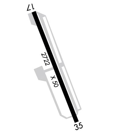
Runway Identifications
Runway Identification: 17/35Length: 2722 ft
Width: 50 ft
Surface: ASPHALT-FAIR CONDITION
Edge lights: Medium IntensityTreatment: NONE
| | Runway: 17 | | Runway: 35 |
| Mag heading: | 174° | Mag heading: | 354° |
| Rwy Slope: | .48% Up | Rwy Slope: | -.48% Down |
| Approach: | | Approach: | |
| Pattern: | Left Traffic | Pattern: | Left Traffic |
| Markings: | NONSTANDARD | Markings: | NONSTANDARD |
| Marking Condition: | FAIR | Marking Condition: | FAIR |
| Arresting Dev: | | Arresting Dev: | |
| Lat & Long: | N4123.2 W07230.4 | Lat. & Long.: | N4122.8 W07230.2 |
| Elev: | 395.0 ft. MSL | Elev: | 408.0 ft. MSL |
| TCH: | | TCH: | |
| Visual Glide Path: | | Visual Glide Path: | |
| Displaced Threshold: | 559 feet; DSPLCD THR MARKED BUT NOT LGTD. | Displaced Threshold: | No |
| Touchdown Zone: | YES | Touchdown Zone: | YES |
| Touchdown Elev.: | 416.0 feet | Touchdown Elev.: | 416.0 feet |
| Visual Glide Slope: | | Visual Glide Slope: | |
| RVR Equipment: | | RVR Equipment: | |
| RVV Equipment: | NO | RVV Equipment: | NO |
| Approach Lights: | | Approach Lights: | |
| REIL: | YES | REIL: | YES |
| Centerline Lights: | NO | Centerline Lights: | NO |
| Touchdown lights: | NO | Touchdown lights: | NO |
| Runway Category: | Runway with a Non-precision Approach | Runway Category: | Runway with a Non-precision Approach |
| Declared Distances: | | Declared Distances: | |
| Obstructions: | TREE | Obstructions: | |
| Marked: | NOT Marked/Lighted | Marked: | |
| Clearance slope: | 1:1; OBSTN CLNC SLOPE 14:1 TO DTHR. | Clearance slope: | 20:1 |
| Obstruction height: | 50 feet AGL | Obstruction height: | |
| Dist. from runway: | 207 feet | Dist. from runway: | |
| Centerline offset: | 66 right of centerline | Centerline offset: | |
| Comments: | +5 FT TREE 56 FT DSTC, 60 FT L. | Comments: | +3 FT BRUSH, 0 FT FM THR, 103 FT R. |
